

We’d first visited the Grand Canyon in 1992, when our daughters were six and nine. With only a half-day, we spent most that time on the Bright Angel Trail for a three-mile roundtrip hike. Quite a feat for kiddos!
Tusayan, Arizona
With this trip, our second, we’d hoped to hike into the canyon once again, but didn’t know if we’d be able to work in a full day’s hike.

Since leaving Carmel, we’d been traveling in “we will figure it out” mode, so had no camping or hotel reservations when we rolled into Tusayan, a town just a few miles from the park’s south entrance.
When the Holiday Inn Express offered a particularly low rate, we figured it out quickly… “Oh, can we actually have the room for three nights, please?”
Tusayan is a walkable town catering to tourists… it’s primarily hotels and restaurants aligning each side of Highway 64. A quick look at Gmaps showed that we were just a block from the Grand Canyon Visitor Center. We rode over after breakfast the next morning.
As we’d done at most national parks, we first watched the informational movie. This one, Grand Canyon, The Hidden Secrets, is quite different.

It’s more of an over-dramatization of folklore involving cougars, hostile natives, and John Wesley Powell; not the historical account of the area’s geology and indigenous people we were expecting. We left a bit disappointed.
The Greenway Trail, a 6.6 mile pathway to the south rim, is accessible from the visitor center’s parking lot.

We were excited to ride our bikes through the pine forest to Grand Canyon Village, where we planned to peel off onto the South Rim Trail. At the time though, the Greenway Trail wasn’t paved. This wasn’t a problem until the path turned into gravel piled 2-3 inches deep. Our tires dug in and we went nowhere. Unsure as to whether the gravel lasted another half-mile or for the entire remaining 6 miles, we turned around and loaded our bikes onto the back of the Escape Mobile. (Note… current photos show the pathway to be paved, but I can’t find whether or not it’s paved for the full length.)

South Rim Trail
Cycling the 13-mile Rim Trail was exhilarating.

On the east side there are sections where the trial is only feet from the canyon’s edge, and the views are amazing.

We rode until we ran into the South Kiabab Trailhead and agreed it would be the trail we’d tackle the next day.

The Rim Trail’s west side is also a peaceful, worthwhile ride. It’s mostly wooded and snakes around lodges and campgrounds setback from the rim.
Back at the hotel we did some research to plan for the next day’s hike… in the morning, after purchasing snacks and sandwiches, we’d fill our backpacks’ water bladders, pack some extra water, catch a shuttle from the village visitor center to Yaki Point, and hike 3-miles down to Skeleton Point – the deepest turnaround spot advised for a one-day down and up hike.
South Kaibab Trail
All the prepping took time so it was early afternoon before we reached the South Kiabab Trailhead.

Although warm for October, it was a gorgeous day and we headed down the canyon’s wall with an excitement-induced quick step. The entire trail is steep, that should go without saying but I’m saying it anyway. It’s easy to get distracted by the surrounding beauty, lose a sense of your downhill pace, and over-estimate just how far you’re capable of hiking in a day. The Rangers’ motto, which they repeat often, is “What goes down, must come up!”

One of the trail’s steepest points is just below the trailhead… a dizzying series of short switchbacks that lead down to Ooh Aah Point, about a mile in. A half-mile farther is Cedar Ridge, the halfway mark to Skeleton Point and a great place for a snack, bathroom break, and photos.


It’s recommended that Cedar Ridge be your turnaround point if hiking during the summer months.


Although warm, we continued downward passing two couples at separate points that had Trey and me raising our eyebrows. They were heading back up, about our ages but not fitness levels, and as Trey noted, “They weren’t looking good!” We ended up passing both couples on the way back up. Not boasting, just noting that one should undertake only what their lungs, legs, and heart can handle.
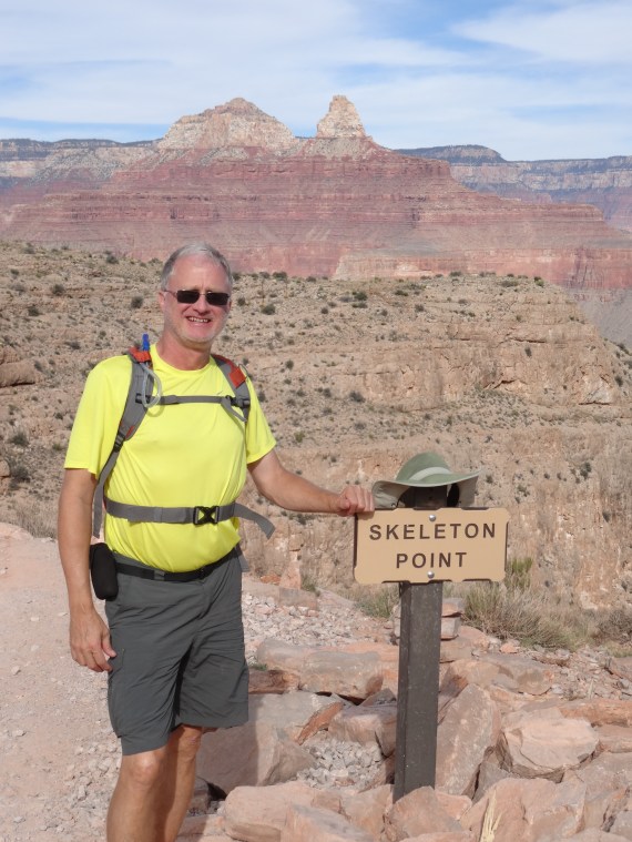
Successfully arriving at Skeleton Point, we were glad to exhale and slow down to rest, eat…

take in the scenery, pose for photos…


and imagine hiking the remaining four miles to the Colorado River, which we could now see.

Yet with our late start, we didn’t linger too long as we knew it would take us double the time to climb back out of the canyon. We kept a decent pace, and were grateful when we returned to Cedar Ridge for a break, more snacks, and photos.

It was nearing the hottest part of the day when we headed up the final steep mile. We took our time and stopped often to enjoy the scenes that we’d scrambled by earlier.


Back at the trailhead we were dusty messes, but thrilled with the day’s challenge, and humbled by Grand Canyon’s grace and ruggedness.

Food:
Yippi-Ei-O Steakhouse in Tusayan is a fun and tasty choice to carb and protein-up the night before hiking into the canyon.

Reminiscence of the Texas steakhouses from our childhoods, Trey and I thoroughly enjoyed the food, great service, and cowboy ambiance. Oh, and the pecan pie was phenomenal!
More Pics…


Last Sunset, Grand Canyon South Rim

Grand Canyon is such a bucket-list destination! I would love to visit one to watch a sunrise and to take in the views. But sadly we are not allowed to go anywhere anytime soon due to the coronavirus. Thanks for sharing and have a good day 😀 Aiva
LikeLiked by 1 person
Great adventure! Loved it! The Grand Canyon is amazing!
LikeLike