Missteps: Grand Staircase-Escalante National Monument & The Wave
I don’t remember what prevented us from researching our next steps, which were to explore Grand Staircase-Escalante National Monument and hopefully hike Coyote Buttes in the Vermillion Cliffs, also known as “The Wave.” It was either our full schedule and lack of regular cell service or laziness and naivety.
Either way, upon leaving Mount Carmel Junction we meandered along Highway 89 for 60 miles until we ran into a Bureau of Land Management (BLM) station and stopped to ask where in the heck we could find the Grand Staircase-Escalante Monument.
We found out that we were already in it and had been for a while. At that time the Grand Staircase – a series of massive geological steps – sprawled out across 3,000 square miles of southern Utah and northern Arizona.
Source: Wikipedia
The downward steps stretched from Bryce Canyon to the Grand Canyon’s northern rim. In 2017 the protected area was sadly cut almost in half.
We were also informed that there’s a lottery process for hiking “The Wave.” The sign-up and drawings take place in Kanab, Utah – a town we’d passed through forty miles back. Backtracking to the Kanab BLM Station we learned that only 10 hikers per day are allowed into the buttes, and that the “lotteries” take place each morning for the next day’s hike.
Should we stay or should we go? We contemplated this question over lunch at Escobar’s Mexican Food (authentic enough) and opted to try our luck and checked into a nearby hotel.
Sunrise in Kanab, Utah
The next morning, we rose with the sun and walked back to the BLM office to stand in line. We were 7th out of 64 to register for the lottery, which was pretty good odds on a relative basis as the average day has well over a hundred registrants. But #7 was not lucky that day, so we checked out of the hotel, and after a breakfast at Nedra’s Too, we checked out of Kanab via Highway 89A South.
The Day’s Route
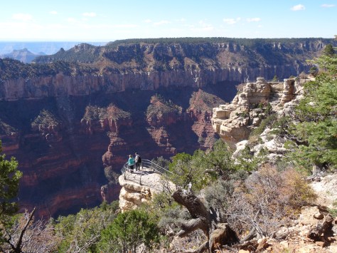
The ranger who on the previous day clarified Grand Staircase’s massiveness had recommended we stop at Le Fevre Overlook, a rest stop along Highway 89A about 25 miles into Arizona. It’s unassuming and easy to miss but worth the stop.
Grand Staircase-Escalante National Monument from Le Fevre Overlook
From the overlook you can make out the distant cascading landscapes that inspired the monument’s name, gaining senses of both its beauty and magnitude.
Grand Canyon National Park – North Rim
Continuing south for just over eleven miles we cut down State Route 67 (also called the Kaibab Plateau Parkway) for the 43-mile drive to Grand Canyon’s northern rim. Being late October, the north rim’s lodges and campgrounds were closed so we had the drive mostly to ourselves.
Along the way, I spied a California Condor perched on the limb of a dead pine and we were reluctantly received by a herd of buffalo on the return trip.
A nip of winter was embedded into the breeze, but the clear sky and sun helped warm us as we strolled along the various paths and vantage points below the lodge cabins…
North Rim Cabins – Grand Canyon Lodge
an environment and scenes that contrasted with what we would experience in the coming days on the canyon’s other side.
Drive from Grand Canyon’s North to South Rim
Leaving the north rim we had a four hour drive ahead of us… plenty of time to circle around the east end of the canyon and make it to the south rim before sunset.
But the drive, curving around and between the Vermillion Cliffs and Colorado River, is spectacular.
Fork of the Colorado River, East of Grand Canyon
We stopped several times including at the unexpected site of abandoned rock dwellings sitting just yards off the road and scattered among mushroom shaped formations.
The legend is that a woman by the name of Blanche Russell was stranded there when her car broke down sometime in the 1930’s. She liked the area so much she settled there for a time.
Ten minutes down the road we stopped again to stroll across the historic Navajo Bridge that spans the Colorado River for 834 feet and parallels it’s replacement… a seemingly identical bridge that is actually wider and longer.
Navajo Bridges – Historic and Current
The “new” bridge was completed in 1995 to support larger vehicles while providing a safe alternative (the historic bridge) for those of us who want to walk over for the views.
Navajo Bridge Over Colorado River
With all the stops we lost our race with the sun.
Arriving at the South Rim
It had set by the time we reached the south rim’s first overlook, the Desert View Watchtower…
Desert View Watchtower Overlook – Grand Canyon South Rim
but enough light shone over the horizon to paint the sky and reflect muted rays across the canyon.
South Rim at Dusk
A perfect welcoming gift to our stay on the Grand Canyon’s south rim.
More Pics…
Lookout at the North Rim
Window View of the North Rim, Grand CanyonMushroom Rock Along Highway 89A, ArizonaColorado River from Navajo Bridge
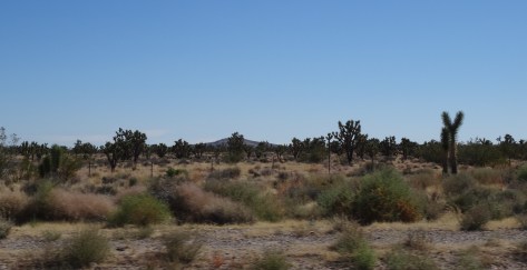
Upon exiting Sequoia National Park we’d entered the Mojave Desert and the portion of this “great looping quest” in which I was most apprehensive… the desert.
West of Las Vegas
I had preconceived notions about desert existence, mostly negative because my perceptions weren’t based on actual experience. So, I’d anticipated a colorless, desolate environment… unfriendly and uninhabitable. After all, the Mojave has a valley named “Death!”
What I discovered was just the opposite, a welcoming beauty, thriving and very much alive. For me, establishing a sense of grounding in the desert required no conscious effort – the desert rose up firmly beneath my feet.
East of Las Vegas, NV
Within Mojave’s arid landscape, where odd and varied creatures flourished, I felt my own belonging.
The desert’s embrace forever changed my perspective, it corrected it and taught me a lesson about the ridiculous power we give to our perceptions.
~~~
A cheap (because it was undergoing a noisy renovation) Las Vegas casino/hotel served as our basecamp while we explored what lies beyond the city’s fringes… the even more wild and wonderful. First up…
Hoover Dam
For a hundred years the Hoover Dam has risen 726 feet from the floor of the Colorado River.
It is an unyielding concrete monster, a sight to behold that attracts some seven million people a year… by car, boat, and helicopter.
Mike O’Callaghan–Pat Tillman Memorial Bridge, Hoover Dam NV
Its proximity to Las Vegas—40 minutes southeast—enables this constant flow of people. Unfortunately, the flow of water for which the dam was built is not as reliable and, as in California, the effect of prolonged drought was visible through the river’s receding waterline.
Receding Colorado River Water Level
We purchased tickets to tour the dam’s power plant… $15 in 2014, and well worth it.
Inside, 30 foot pipes snake through tunnels and rows of enormous generators churn out 4 billion kilowatt hours of electricity annually for the good folks of Nevada, Arizona, and California. The dam’s structure also serves to control flooding and reserve water for California’s fruitful valleys and its southern cities.
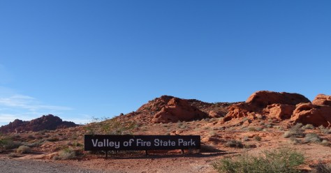
Valley of Fire State Park
Nevada’s Valley of Fire State Park is located about 50 miles (an hour’s drive) northeast of Las Vegas. Its sculpted red rocks are stacked and scattered throughout the park’s 40,000 acres.
Valley of Fire Landscape
Only one road cuts through the park, just above its southern border. The road provides access to loads of popular hikes and fun formations, more than enough to keep one occupied for a day.
The rest of the park, the vast majority of its wilderness, is a sprawling preservation area, seemingly inaccessible except by foot.
Our arrival in the late afternoon limited our hiking options, but we had the park to ourselves.
Mouse Tank Road, Valley of Fire State Park, NV
Also, the sun’s low stance illuminated the red rocks and danced through canyons making our walks even more magical.
Balanced Rock
Elephant Rock
The half-mile trail to Mouse Tank led us down a canyon marked with hundreds of petroglyphs.
Mouse Tank Trail Valley of Fire State Park, NV
These uninterpretable messages hovered just above us, holding steadfast onto the secrets of an ancient civilization.
Only the sunset, spectacular and fleeting, could force us out of the Valley of Fire and back toward the maddening lights of Las Vegas.
Death Valley National Park
We traveled northwest for 140+ miles to enter Death Valley National Park where my attitude and apprehensions about deserts were permanently altered. Death Valley’s mystique and it’s rolling, constantly changing landscapes captivated me.
View from Zabriskie Point, Death Valley National Park
We stopped often, awestruck by its colors and geology.
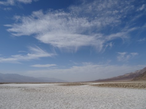
Near the center of Death Valley is Badwater Basin, a massive flat of salt exposed by rain runoff from the surrounding mountains.
The basin sits 282 feet below sea level, the lowest point in North America.
Badwater Basin Salt Flat, Death Valley National Park, CA
Its limited drainage results in artsy, salty shapes forming through heat induced evaporation. The salt configurations cover the basin creating an eerie, alien terrain.
We traversed over the salt and out into the basin and became mesmerized by the patterns. Before we realized it, we were about a mile in, which is nowhere near the basin’s center.
As intense heat began pulsing around us, we sensed our own vulnerability and soon turned back toward the parking area.
Artists’ Drive, Death Valley National Park, CA
Wending through a painted canyon on Artists’ Drive was like bounding through a rainbow. The one-way nine-mile road is narrow with rocky hillsides rolling up, out, and along both sides.
The palette effect is from minerals (including hematite and chlorite) altered by volcanic eruptions five million years ago. Elements aluminum, iron, magnesium and titanium also add to the mountainous canvas.
Our other hike in Death Valley, was the Natural Bridge Trail, accessible about a mile and half down a dirt road that breaks off from Badwater Road.
Trey heading down Natural Bridge Trail, Death Valley National Park
It’s an easy one-mile round-trip trail into a narrow, high-walled canyon.
The trail crosses under the bridge formation and continues into a box canyon.
Natural Bridge, Death Valley National Park, CA
We had the trail to ourselves, or at least it was devoid of other humans. This gal, a Swainson’s Thrush, accompanied us from the rock bridge to the trail’s end.
Death Valley Swainson’s Thrush
As we neared the bird, it would take flight, landing 20 or so feet up trail where it waited for us to approach again. Over and over it repeated this routine, escorting us all the way into the rocky boxed area…
and then safely back to the bridge.
We also spied a reddish fox, the Desert Kit Fox, strolling alongside Hwy 190 as we left the park, but missed photographing him.
We’d left Carmel-by-the-Sea for Yosemite National Park without plans for where we’d sleep for the next three nights. Securing a campground reservation had proven impossible, so our shaky plan B was to show up, stand in line, and hope there’d been a last minute cancellation.
As we detoured across California to avoid wildfires, the hours passed into late afternoon and we grew even less confident that shaky plan B was the way to go. Still, we progressed forward and climbed closer to Yosemite’s south entrance as the sun fell below the surrounding mountains. Three miles out, we came upon what appeared to be a forest oasis — a beautiful lodge.
Source: tenayalodge.com
It also appeared to be way outside of our budget, but it had spoken to both us. As we passed it, Trey and I looked at each other and in silent agreement, Trey turned the Escape Mobile around and headed back, “It can’t hurt to check it out.”
The Tenaya Lodge was definitely a splurge, but Trey and his baby blues secured a hefty discount, making it doable. Walking in without a reservation proved to us once again that, “The Universe is on our side!”
Yosemite National Park
With only two days to explore Yosemite we planned to cram in as much as possible. We hadn’t previously visited the park, but, based on everything we’d heard, we had high expectations.
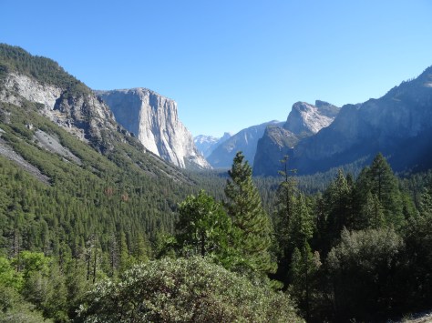
Bicycles in tow, we twisted northward along Hwy 41 toward Yosemite Valley. I thought the scenery was nice, but wondered, why all the hype? That is until a sharp curve led us into a tunnel and we emerged on the other side to this view…
I wish there was a word for when everything you thought you knew gets thrust into proper perspective by unimaginable beauty and grace — those moments when you only feel humility and gratitude for the honor of the experience.
It would have to be a particularly full, bold word, one that rolls off the tongue, such as flumgustered or hyperevoluted. Well, I guess there is wonderstruck, but no; I was flumgustered to tears, my conscious was hyperevoluted as I grasped the immense power of nature’s mass and force.
Majestic El Capitan
We had a full day of exploring ahead, but the “Tunnel View” beckoned us to stay. So spying a trailhead above the parking lot, we headed up Inspiration Point Trail for a higher vantage. The 1.3 mile path provided even more magic: flying squirrels soared across the trail in front of us; mosaic pine tree trunks enticed us upwards…
and massive madronas painted the pathway with white blooms and redbrick limbs.
The path to Inspiration Point is steep but the views are truly inspiring and worth the climb.
By the time we left the Tunnel View area and arrived in Yosemite Valley we were famished, so we shared a generous bowl of chicken rigatoni at the majestic Ahwahnee Lodge.
Our bicycle tour was delayed further as we stuck around the Ahwahnee parking lot to gawk at freestyle climbers inching their way up Washington Column.
With its 12 miles of pathways, Yosemite is perfect for exploring by bicycle.
The remaining afternoon was spent peddling the length of the valley, crossing historic stone bridges…
…and stopping for short hikes through meadows and up to Lower Yosemite Falls, which was almost a trickle.
Free climber up Lower Yosemite Falls
The afternoon’s highlight was spotting a momma bear and her cubs loading up on ripening apples in preparation for the approaching winter.
California was in extreme drought, this was evident on the drive from Carmel, and it was obvious throughout Yosemite Valley.
The Merced River was barely flowing and the mountain creeks feeding it were bone dry. That, however, did not take away from the beauty of Yosemite.
Half Dome
El Capitan
The sun’s descent was progressing as we re-secured our bicycles to the back of the Escape Mobile — a timing that we hadn’t planned, but was perfect for sidetracking up Glacier Point Road.
The drive-in-and-out road is just shy of 16 miles (each way). It cuts up from Wawona Road (Hwy 41) just south of Tunnel View, and twists deep into the wilderness. (We spotted what appeared to be a wolf on the drive up, and a coyote on the return trip.)
The sunset panoramas were spectacular as was the view of the valley below. From the height of Glacier Point one easily sees how and where ancient monster glaciers cut through mountains to carve out the valley.
Yosemite Valley from Glacier Point
We hadn’t anticipated the bonus of the setting sun’s colors reflecting off the eastern rocky cliffs.
Half Dome from Glacier Point at Sunset
We stood mesmerized, flumgustered, until we noticed stars beginning to dot the darkening sky.
We secured ourselves among boulders a safe distance away from the mountain’s ledge and watched as the stars slowly painted the sky. We also noticed mysterious lights appearing one-by-one on the face of half-dome… climbers tethered to its ledges for the night.
Camper’s light on the ledge of Half Dome
As blackness fell over us, we hoped to see the milky way. However, due to a significant decrease in temperature coupled with the realization that we had no flashlight for the half-mile rocky trek back to the car, we decided to follow another couple down from the observation deck. (They had a flashlight.)
Mariposa Grove
We’d already fallen in love with the giants of Redwood National Park, but had yet to experience the noble Sequoias.
A planned short hike through Mariposa Grove turned into an all-day 8-mile journey.
With soft intent we strolled through the grove, communing with the giants along the way.
Columbia Tree
Clothspin Tree
The grove was declared as “Mariposa Grove” after a couple of white dudes, Galen Clark and Milton Mann, happened upon it in 1857.
However, evidence of indigenous people occupying the area dates back 3,000 years; Grizzly Giant would have been a mere sapling.
Grizzly Giant, Mariposa Grove
The Universe is on Our Side… Again
A reversing incident in Yosemite had somewhat destabilized our bicycle rack. So before heading to Kings Canyon National Park, Trey tightened each bolt and balanced the rack securely enough to make it the 60 miles to Fresno. (We had assumed that Fresno was the closest city large enough to have a proper bike shop.)
We’d traveled only 14 miles, to the tiny town of Oakhurst, when the rack’s arm flailed backwards and dangled our bikes sideways a few feet above the pavement. We immediately pulled into a parking lot and checked for phone service. Two bars allowed me to search for the nearest bike shop.
Gmaps seemed to be confusing our location with that of the nearest bike shop, so I looked up and around for assurance. Right there in the same parking lot, and directly in front of where our bikes had nearly crashed to the road, was Yosemite Bike & Sport. It wouldn’t open for another 10 minutes, but we walked over to the store front anyway to check out the shop while we waited.
Driving through terra incognita and having one’s bicycle rack deconstruct directly in front of the only bike shop within in a 60-mile radius is magical enough. Right? Well, not this day. As we approached the store’s display window we couldn’t believe what we saw… our exact bicycle rack sat new, fully assembled, and ready for use. (And no, it wasn’t a common brand or model.)
Like in Chicago and Portland, staying in or near San Francisco’s city center was cost prohibitive, so we again used points and stayed at an airport hotel. The commute into San Francisco was about 25 minutes but ran aside the beautiful San Francisco Bay. Finding parking was never a problem as there are plenty of public, but pricey, garages.
Alcatraz – Messages of Freedom and Justice
Alcatraz is part of the National Park Service’s Golden Gate National Recreation Area. A ferry operated by a private company from Pier 33 is the only means to access the island. They run about every 30 minutes and you have to purchase fares for a specific departure time, but you can return whenever you’re ready.
That was a good thing as Trey and I became captivated by the island… its history and stories, and all the once hardened but now deteriorating skeletal structures juxtaposed amid beauty. (One only needs to look.)
We spent most of the day touring the former military outpost-then military prison-then federal penitentiary-now national treasure.
During our visit, Alcatraz was also serving as an art exhibit space. We were fortunate that our trip coincided with Chinese dissident artist Ai Weiwei’s exhibit @Large: Ai Weiwei on Alcatraz.
The installation exhibit filled two work rooms, and began with the wonderful, welcoming face of a giant, intricate paper dragon, its body comprising the full length of the room.
The contrast of vibrant colors against decaying prison walls was surreal. As were the Lego portraits and brave words of individuals imprisoned for voicing or acting upon their truths…
including Mr. Weiwei himself who at the time was being detained by the Chinese government.
The entire island is open for exploring and we spent as much time outside as we did inside the various cell blocks, industry/labor buildings, and administrative offices.
The NPS has done a great job (as always!) in telling and preserving Alcatraz’s stories, from its notorious prisoners and attempted breakouts to those of the families and children of guards that were also Alcatraz residents.
Recreation of cell used in notorious breakout and subject of the movie Escape From Alcatraz
We learned about the Native American 19-month (Nov 1969 – Jun 1971) occupation of the island. The cross-tribe participants (including the late Cherokee Chief Wilma Mankiller) claimed the island as their own citing an 1860’s treaty.
In reality, the takeover was an act of rebellion for past and ongoing injustices carried out by the U.S. Government against its native people. The civil disobedience effort was successful at calling attention to those injustices and their continued effects. We were happy to find that signs of the occupation are well preserved and protected as part of Alcatraz’s rich history.
San Francisco by Boat, Car, Bike, & Foot
BOAT Just before leaving Austin for this trek around the U.S., Trey and I struck up a conversation with a businessman at the downtown PF Chang’s bar. He was from San Francisco, so we quizzed him on what his #1 must-do-in-San Francisco recommendation was. “That’s simple!” he said. “You have to see San Francisco from the vantage point of its bay – sail out into the bay and under the Golden Gate Bridge.”
That’s exactly what we did on the “Privateer” through the San Francisco Sailing Company. The day was gorgeous, perfect for sailing! Plus, the unique views and perspectives we experienced were well worth the $60 ticket price.
We struck up a conversation with a couple sitting adjacent to us on the cozy sailboat and soon after regretted doing so. They were weirdly interested in us and toward the end of the trip, a bit too touchy and invading our personal spaces. We politely declined their invitation to join them at their home thinking that the boat’s sails were not the only thing they wanted to experience swinging that day. California!
The bay was beautiful though, and like our no-strings-attached friend at PF Chang’s, we highly recommend sailing around it to fully enjoy the San Francisco skyline and surrounding bridges and hills.
CAR Beginning in the late 1800’s and through World War II, the entrance to San Francisco Bay from the Pacific Ocean was deemed militarily vulnerable.
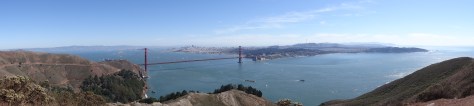
As such, a series of defense “batteries” were constructed along both the northern and southern shores. The remnants of these fortifications remain for intrigued tourists to explore. We selected the northern shore route because it allowed us to drive across the Golden Gate Bridge, a new experience for Trey.
Once across the bridge, we followed Conzelman Road that curved around the hills’ edges and offered amazing views of the bay, bridge, and city.
Stopping at Kirby Battery gave us a feel for what guarding America’s western gateway was like during World War II.
It’s easy to imagine diligent soldiers scouring the ocean’s horizon for enemy vessels and the skies for foreign aircraft while bunkered behind sixteen-inch barrel guns. The never used guns are long-gone, but the bunkers and other structures are open to climb about, picnic on, or find a peaceful moment while taking in the serene beauty.
Trey posing in a Kirby Battery tunnel
Continuing on Conzelman Road until it dead ended, we turned left onto Field Road which leads to the steep ledge of Bonita Point. The tiny Bonita Point Lighthouse sits atop a rugged crag and is accessible via a wooden suspension bridge – a good challenge for those wanting to confront a fear of heights.
The ocean and bay views are spectacular, but we enjoyed the scenes below the most… sunbathing seals and ocean spray rising from waves crashing upon black rocky ledges.
Heading inland on Field Road, we made our final stop back in time at Nike Missile Site SF-88…
Greely & Norton greeted us upon our arrival and kept careful watch over things
where we walked above ground among retired missiles and below ground where missiles were stored and readied for launch.
The site closed in the 1970’s and is well maintained by the NPS. Just as the old battery sites had done, this retired missile site provided a good sense of life at a cold war defense site.
BIKE From The Embarcadero’s Pier 39, it is about a 5.5 mile ride (one-way) across the Golden Gate. The route takes you along the beach, by gorgeous waterfront homes, and through Presidio to the Battery East Trail.
The climb up to the bridge is steep, but there are plenty of overlooks to stop, rest, and take in the changing scenery… another great way to enjoy the cityscape.
As we climbed we noticed a thick fog rolling in at a fury’s pace. It quickly engulfed the bridge and we wondered whether we’d be able to ride across the bridge, and if so… would we be able to see anything? By the time we huffed our way to bridge level and emerged from the trees there was no trace of fog, not a single remnant.
I understand that is how fog is in the bay area… it is an entity in itself, choosing to come and go, disrupt and displease at will.
The ride across the Golden Gate was thrilling. The rails are high enough and the path wide enough that we felt perfectly safe and comfortable crossing over and back on the 1.7 mile bridge.
Along with sailing around the bay, I consider bicycling across the Golden Gate as a San Francisco must-do!
FOOT We fell in love with San Francisco. It’s a very walkable city if you don’t mind hills. If you’d prefer to avoid hills then stick to the shoreline areas of Fisherman’s Wharf and the Embarcadero.
With loads of fabulous restaurants, shopping, boats, nightlife and wildlife, they contain essential elements of the quintessential San Francisco experience.
We also loved walking through Pacific Heights, China Town, and Telegraph Hill.
Lombard Street, San FranciscoTelegraph Hill, Coit Tower
Golden Gate Park was on our itinerary, but the streets surrounding it were impassable due to an annual bluegrass festival. Next time!
San Francisco Food
Breakfast – To offset the expense of eating out, we started most days with a cheap but hearty breakfast from Ed’s Diner in South San Francisco.
They served an excellent version of Trey’s favorite, the traditional American breakfast. We would fill ourselves enough to skip lunch and then carry a snack bar and piece of fruit to make it to dinner.
Our one breakfast exception was Mama’s On Washington Square, a recommendation by my sister-in-law who grew up in San Francisco.
We were warned that it is small and there is always a crowd, so we arrived twenty minutes before its 8:00 a.m. opening time. That wasn’t early enough to keep us from waiting in line, but the owner-operated café knows their business and has perfected a system of getting people in the door, through an ordering line, seated, served, and back out the door with a full stomach and happy heart.
The freshness and quality of the food is tops! The menu is extensive so I felt a bit overwhelmed with being pressured to order quickly and not hold up the line. We also completely forgot to record or photograph what we ordered.
Dinner – This is it! My absolute favorite dish from our trip around the United States…
Crab Enchiladas, Crab House – Pier 39
Crab Enchiladas from the Crab House at Pier 39. They were what I imagine eating in Heaven will be like. A melt in your mouth unique flavor, yet still enchilada tasting enough to be called an enchilada. The above photo is not an exaggeration, together the two enchiladas were the size of a Texas big-as-your-face burrito and I finished off each one then wiped the skillet clean.
Even Trey, who is not a shell food person, enjoyed the small bite I shared. He opted for the Fish & Chips, a very generous portion of perfectly fried and fluffy cod, served just as it should be.
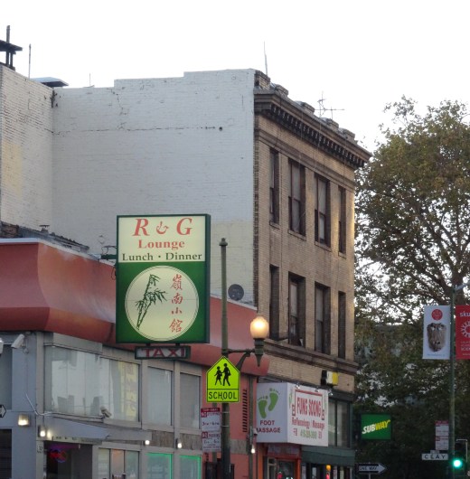
R & G Lounge in Chinatown – Authentic, traditional Chinese. We Texans felt a little out of place and lost at first, but the servers were kind and helpful, and the food was excellent.
McCormick & Kuleto’s Seafood & Steaks, Ghirardelli Square – we failed to take a photo of our meals and neither of us recall the meal. We do, however, vividly remember the gorgeous bay views.
We watched swimmers doing their evening laps while the sun set behind the hills and turned sailboats into silhouettes.
Dessert was a Caramel Sea Salt Hot Fudge Sundae that we split from Ghirardelli Chocolate Factory.
Beginning in Red Lodge MT, and continuing for the preceding 45 days, we’d followed the first appearances of fall colors across the west and down the Washington and Oregon coastlines. Random wisps of cool air and pronounced temperature differentials had been nipping at our backsides, nudging us forward just ahead of autumn’s arrival.
With the unanticipated deluge that forced us out of the Redwood Forest, fall had officially won the race and taken over. Its conquest coincided with a planned eastward turn into the mountains toward Nevada…
the first of several detours that had us zig-zagging across, in and out, and down the state of California for the next month and a half. (See our California path on our “About” page.)
From Arcata, we followed the Trinity River via State Highway 299.
Trinity River, Hwy 299 toward Redding
The river, changing leaves, grazing elk, along with a mix of rain and mist enhanced the gorgeous drive across northern California to Redding.
Trinity River, off Hwy 299 Northern CA 2
Still soaked and with an extra day, we stopped in Redding and checked into a hotel. After showering, we hauled our camping gear into the room, sorted and dried everything including our tent, which we pitched atop the spare bed.
Yelp and a hankering for comfort food led us to Nello’s Place for a cozy Italian dinner – one of our most memorable dining experiences in quality, service, and for being exactly what we needed when we needed it.
Dungeness Crab Cake, Nello’s Place, Redding, CA
Funny how what first appears to be a mishap ends up being a beautiful gift. These magic-of-the-Universe moments occurred often on our trip, just as they do in life.
In frustration, we tread through life’s darkness and around its rough edges as best possible only to end up somewhere completely unexpected, almost like an award for making it that far. It is only then that you recognize the past’s challenges as beautiful puzzle pieces laid out behind you, perfectly placed together.
One only needs to take the time to notice.
Elk buck along the Trinity River, Northern California
Over the last shared bites of Nello’s cherries jubilee, our favorite dessert experience on the trip, we expressed our deep gratitude for simply being in that moment, and for the obstacles that had led us there.
North Lake Tahoe, California
To avoid driving around Lassen Peak’s mountainous roads in a thunderstorm, we headed south from Redding along the Sacramento River and into the Central Valley. The sun and blue skies soon appeared highlighting the valley’s olive and pistachio orchards…
Barely an hour into our drive, the geography had completely changed. We found this to be true in most areas of California — if you don’t like the scenery, just drive an hour in any direction.
Heading into the Sierra Nevada Mts
The clouds and rain returned after steering eastbound again into the Sierra Nevada Mountains.
But, the weather was forgotten upon setting eyes on Lake Tahoe’s vibrant blue hues. We were captivated and regretted having less than 24-hours to enjoy them.
That is until frigid air blew in with a storm foiling our plans to bike, and keeping us inside our small rented cabin for the evening.
Public Beach, Tahoe Vista, North Lake Tahoe
All was good as our rustic cottage was comfy and adorable, and looked out onto Lake Tahoe.
Escape Mobile parked at Rustic Cottage Resort & Motel
We watched from the warmth of our cabin as wind gusts and waves knocked around boats docked along the shoreline.
Driving across the Mount Rose Highway the next morning, we were stunned to find a light snow had dusted the mountain and roadsides. Snow in September, another first!
Snow dusting Mt. Rose in September 2014
Family Reunion – Reno, Nevada
Reno, Nevada
Because Reno is the home of my brother and most of his family, a visit to the biggest little city in the world had been on our must-do list since our trip’s onset We loved catching up with our family! And touring Reno…
Truckee River cutting through central Reno
Galena Creek Bridge near Reno, NV
a progressive, beautiful city surrounded by mountain vistas, and not at all similar to what Hollywood tends to project.
We spent an afternoon with my brother exploring the terrain and historical sites along State Highway 341, also referred to as the Virginia City Scenic Drive. We climbed along mountain edges, passing wild horses, and into the infamous silver-mining town of Virginia City.
Virginia City’s main street
Take away the paved highway cutting through town, along with all the cars and motorcycles, and Virginia City appears closely to what I imagine it did in the 1800’s. With its redbrick buildings, colorful storefronts and covered wooden walkways, Virginia City offers visitors a taste of living on the outer edge of law & order in the old west.
Virginia City, Street Vibrations Rally
Our visit happen to overlap the Street Vibrations motorcycle rally. Like in the Black Hills during the Sturgis rally, new and classic Harley’s lined Virginia City’s main street, augmenting the fun outlaw vibe.
Reno is a lovely city, and our visit with family was too short.
California Quail in my brother’s backyard
Lesser Goldfinches
It was difficult to say good-bye; this was the last of many reunions on our trek and we still had two months of travel ahead.
Having heard of Portland’s similarities to Austin (music scene, laid back feel, open-minded residents, etc.), we were ready to experience a taste of home.
Staying in downtown Portland wasn’t feasible, in either dollars or hotel points. Instead, we used points to stay near the Portland International Airport and used Portland’s MAX Light Rail system to get around. The Red Line stopped directly in front of our hotel; from there it was a straight shot into the heart of Portland, so the Escape Mobile remained parked for most of our stay!
Waterfront Biking
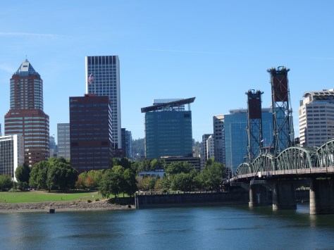
Portland’s most notable similarity to Austin is its river, the Willamette, which cuts through the city’s center.
City and Hawthorne Bridge View, Portland
Both banks of the Willamette River are aligned with businesses, hot spots, public parks, gathering spaces, and walking/jogging/biking paths.
Convention Center Towers
Carrying our bikes onto the Red Line, we stopped west of the river to begin a clockwise 11-mile waterfront ride. The Sellwood Bridge Loop led us alongside downtown and across the iconic Steel Bridge, a double-decker vertical-lift bridge completed in 1912.
Steele Bridge Portland
Biking along the Willamette was a great way to explore the city and spot wildlife.
Trey on the Sellwood Bridge Loop
Osprey on the Willamette River
Trey was thrilled at the site of a decommissioned naval submarine, the USS Blueback (SS-581)…
USS Blueback (SS-581)
and we both loved the row of float houses near Sellwood Bridge!
Columbia River Gorge
View of Columbia River Gorge from Vista House
The Columbia River Gorge begins about twenty miles east of Portland and is accessible via U.S. Highway 30, also known as the Historic Columbia River Highway. The first must stop is Vista House…
an overlook and information center completed in 1918 located on Crown Point, one of the gorge’s highest points. Vista House offers great panoramas of the gorge, river valley and surrounding hills.
We were surprised to see windsurfers whisking atop the Columbia River, but the area below Crown Point is a popular spot for the sport.
Waterfalls dropping from rocky cliffs dot the riverbank as you head east into the gorge. Most, including Latourell Falls and Shepperd’s Dell, are either visible from the highway or a short hike.
Latourell Falls, Columbia River Gorge
Fall Colors at Shepperd’s Dell Falls
Bridal Veil was our favorite. The trail crosses a creek that may deter some from completing the half-mile trek, but keep going. The two-tiered waterfall is definitely worth it!
Trey at Bridal Veil Falls
We climbed atop a huge boulder and basked in the sun while red and yellow leaves rained down upon us.
Multnomah Falls, photographers’ favorite, was packed and we had to nudge our way across Benson Bridge to access the trail to the top of the falls.
Multnomah Falls, Columbia River Gorge
The roundtrip 2.2 mile hike climbs 700 feet via eleven switchbacks. Although it’s labeled as moderate, wear hiking boots or tennis shoes and allow time for breath breaks if you’re not in good shape.
The 4.8 mile loop trail we’d planned to take from the top of Maltnomah Falls over to Wahkeena Falls was closed, so it was down the switchbacks to the car for a backtrack drive west.
Wahkeena Falls, Columbia River Gorge
Trey hopped over the concrete barrier, across mossy rocks, and balanced on the creek’s ledge to get the above shot.
Portland Night Life
While visiting downtown for dinner the evening of our arrival, we were surprised to find Portland streets subdued with only a few people out and about. We figured that was because it was a Thursday. The next evening, and after a long day of bicycling, we explored the Pearl District, an area described as “buzzing” with loads of unique dining options. While there were a few more folks walking around the Pearl District, there was neither buzz nor music. This was consistent throughout our stay.
Portland lacked Austin’s vibe, that definable energy evident upon deboarding at Austin-Bergstrom International Airport where one is met with local eats and live music.
Although the weather was gorgeous, maybe our visit coincided with Portland’s downtime, or we turned down the wrong street and missed music venues. I don’t know.
The most excitement we observed were the long, munchie lines outside of Voodoo Doughnuts. Maybe that’s why all the good people of Portland were so quiet and laidback?
Mountainous Horizon
On the Red Line from the airport, there’s a five-second window where Mt. Hood, Mt. Saint Helens and Mt. Rainier can all be viewed.
Mount Hood from MAX Light Rail Red Line
You need a clear day and good neck flexibility; we managed it once.
A local informed us of another vantage point in town where there’s time to appreciate the views and take photographs. In the late afternoon and on our way out of town, we stopped by Pittock Mansion, a restored chateau built in the early 1900’s by one of Portland’s legacy families.
We arrived too late to tour the home, but enjoyed strolling the magnificent grounds and the views of Portland.
Unfortunately, clouds and haze prevented us from seeing any mountains before it was time to hit the road again.
Destinations Known: Coos Bay for the night, then into the Redwood Forest!
More Pics…
Boat dock near Hawthorne Bridge
Latourell Falls through the trees
Tiny Waterfall along Columbia River Gorge
Trey on hike to Bridal Veil FallsElmer’s German Pancake, Yum!
Quaint Astoria sits on a peninsula barely east of where the Columbia River clashes with the Pacific Ocean. Outlined by Young’s Bay and River on its southern shoreline, with the mighty Columbia River comprising its north border.
Above Astoria, looking west: Views of the Pacific and Columbia, Young, and Lewis & Clark Rivers.
Yes, water is the heart, soul, and breath of the community. Its sustenance, and existence.
Accessing Astoria from Washington State requires either a boat or crossing the massive Astoria-Megler Bridge, a cantilever through-truss design. As we drove the 4.1 miles across to Oregon, my thoughts turned to my sister. Many times, she had relayed her dizzying experience bicycling over the Columbia River while water rushed in one direction below and crisscrossing cars whizzed past her side. I was grateful to be inside the Escape Mobile.
Astoria’s Welcome Party
Checking into our riverfront hotel just before sunset, we were greeted with an unrecognizable noise permeating throughout the lobby. Curiosity led us down a corridor and out a back door where the now recognizable barks overwhelmed our senses. Seals, hundreds of them, had taken over docks and landings sitting 150-ish yards away. Gladly, the barking did not disrupt our sleep.
With one full day to explore Astoria, we made the most of our time. First order was a must-visit to the Goondocks…
The Goonies House
a row of Victorian houses made famous in the 1985 Goonies movie. While we easily found parking and walked up to the primary “Goonies’ House” to snap photos, increased tourist traffic and mishaps have since halted such practices.
Next, a walk around and up into the Astoria Column provided both a historical accounting and scenic overview of the area.
Styled after Rome’s Trajan Column (which Trey has since visited), its spiraling pictorials tell of the “discovery” of the Columbia River, Lewis and Clark’s expedition, and the arrival of John Jacob Astor’s merchant ship which was instrumental in establishing Astoria as a key outpost in North America’s fur trade, helping Astor to control much of that trade. How ironic, or perhaps “offensive’ is more fitting, that Astor’s descendants later dedicated the column as a memorial to the Chinook Indians.
The remainder of Astoria was explorable by bicycle via The Riverwalk…
Trey on The Riverwalk near base of Astoria-Megler Bridge
a roughly 5-mile pathway following the Columbia River bank from the peninsula’s westernmost point, and turning into forested hills at the eastern end.
Eastern end of Astoria’s Riverwalk bike path
Along the way, The Riverwalk provides easy access to downtown shops and restaurants. Note, a trolley line follows much of the pathway.
During our bike ride, we enjoyed eating wild blackberries growing aside the pathway, watching the day’s catch being unloaded, the ever-present wildlife, and being entertained by Coast Guard drills while eating pizza.
Astoria is charming with a laid-back, fun vibe that balances well with the hard work and challenges that I imagine accompany living at the convergence of three rivers and an ocean. Also apparent was Astoria’s reliance on tourism.
Astoria Food experiences…
A bit of a foodie city, there were several on-budget options. Five stars to T Paul’s Supper Club for dinner, Street 14 Café for coffee and lunch, and the chain restaurant Pig N’ Pancake was a breakfast favorite for locals and tourists.
Fort Clatsop – Lewis and Clark National Historical Park
Fort Clatsop is just south of Astoria so we saved this historical site for the morning of our departure. The fort sits where the Lewis and Clark expedition settled in for winter, awaiting and planning for their return east.
All structures are replicas based on surviving journal entries. A footpath leads to the Lewis and Clark River and follows the shore 1-1/2 miles to Netul Landing (Netul is the river’s original name).
View of Lewis & Clark River from footpath to Netul Landing
US Hwy 101 Coastline Drive – Part Two
Mesmerized with our first Oregon coast drive, we stretched the 2 hour and forty minute trip to Lincoln City into most of the day; stopping at numerous overlooks…
touring Tillamook Cheese Factory…
Tillamook’s exceptionally clean packaging area
and traipsing between homes to access a public beach…
Lovely day best expressed through photographs:
We arrived in Lincoln City at sunset, without hotel reservations, and famished. Trey had spotted Puerto Vallarta Mexican Restaurant as we entered town — best Tex-Mex fix since Pittsburgh, margaritas included of course.
Trey checking in
Lincoln City’s Sailor Jack Inn stands out as one of our more memorable sleeping experiences; notable in a unique, funny, and lets-not-do-that-again way. It was a cheap motel with a million dollar view.
Slinking carefully into bed, we drifted to sleep easily to the sound of crashing waves. I’m sure the margaritas were helpful, too!
Woke the next morning to clear skies, and another Pig N’ Pancake breakfast fueled our bodies for the drive inland to Portland.
More pics…
This is a record of Trey & Martha's 2014 U.S. travel adventures


 Nevada’s Valley of Fire State Park is located about 50 miles (an hour’s drive) northeast of Las Vegas. Its sculpted red rocks are stacked and scattered throughout the park’s 40,000 acres.


")


")


")