Leaving Las Vegas we were once again traveling in “we will figure it out” mode. Oh, we knew where we were heading, Zion National Park, but had no idea whether we’d spend the night there, nearby, or move onto Bryce Canyon. Sluggishness had delayed our departure so we didn’t arrive in Zion until 4pm… much too late to snatch a camping site.
Pa’rus Trail, Zion National Park
Thinking the remaining daylight was all the time we’d spend in the park, we hopped on our bikes for a quick tour.
The Pa’rus Trail is a paved path that begins near the visitor center, wends around the campground and along the Virgin River for 1.7 miles…
Virgin River from Pa’rus Trail, Zion
…ending at the intersections of Hwy 9 and Zion Canyon Scenic Drive.
Crossing Pine Creek, Pa’rus Trail, Zion NP
We continued up (and I do mean up!) Zion Canyon Scenic Drive for an additional five miles, stopping to take in the scenes of Great White Throne, Court of the Patriarchs, ant-like hikers clinging to cables along the West Rim Trail…
…beautiful passages of the Virgin River, and wildlife.
The Virgin River, Zion National Park
At the road’s end, we were captivated by the towering Temple of Sinawava—the 3000’ canyon wall that entices hikers into its chasm, The Narrows.
Alas, we had figured it out… with hands on our breaks and feet off our pedals we sailed downhill and then back to the nearest town – Springdale, Utah – to find a hotel and prep for the next day’s hike.
The Narrows (Virgin River) – Zion National Park
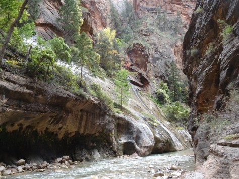
The Narrows was the most extraordinary, and probably our most memorable, hike of this six-month trek.
It’s not really a trail, or rather, the trail (Riverside Walk) ends after a mile, and to continue into The Narrows one must enter and follow the Virgin River upstream.
The water was frigid, but the heat and blood flow generated from traversing over rocks helped our toes acclimate pretty quickly.
Water and mineral stained canyon walls were capped with plant life and fall colors. We’d entered a seemingly mystical environment, surreal, but not without lurking dangers.
The river is unpredictable in flow and depth, and I once found myself suddenly waste deep.
As we slogged farther into the narrowing canyon its rock walls grew higher and more solid.
Trey in The Narrows, Zion National Park
Time passed, but without a sense of our pace in the water, we had no idea of how far we had traveled. There were no mile markers, probably because it’s not a trail, but when we reached an intersection with another canyon that broke off to the east, Trey correctly estimated we’d hiked about a mile and a half since entering the river.
We followed what ended up being Orderville Gulch for only a few hundred feet before turning around and heading back downstream.
Our turnaround point: Orderville Gulch, The Narrows, Zion
At 6pm, we left Zion National Park via Highway 9 and with senses of accomplishment and regret.
Zion National Park – East of Hwy 9 Tunnel
The Narrows was an amazing hike, a once-in-a-lifetime experience that will stay with us forever; yet Zion had many gifts and trails we were leaving uncharted. As the majestic beauty of Zion’s eastern border folded out around us…
…we concurred, we’d have to make a return trip.
More Pics…
Virgin River from Pa’rus Trail, ZionTrey hiking The Narrows, Zion National ParkZion National Park
The “Redwood Forest” is a patchwork of federal and state parks along California’s northern coastline.
Together, they’re a UNESCO World Heritage site with joint missions to manage and preserve the remaining old growth forests. Before effective efforts to protect the giant redwoods were established, logging had wiped out 70% of them. Yes, 70%!
Arriving at the Jedediah Smith Redwoods State Park, located in the northern end, we’d officially traveled from the gulf stream to the redwoods.
Being surrounded by new growth trees and thick underbrush provided our campsite some privacy. And for me, senses of comfort and safety came with sleeping among the giants.
We spent our afternoon exploring the campground and forest. Trey and I had previously encountered a few giants – a young transplanted sequoia in Victoria’s Butchart Gardens, and firs around Mount Rainier and Mount Olympus – but those trees did not prepare us for the magnitude, majesty, and grace of the old growth redwoods.
It was love at first sight!
The park’s campground sits alongside the Smith River.
Smith River, JS Redwoods SP
Being September, it was unlikely we’d catch a trout or salmon, so we didn’t purchase licenses. Instead, each evening we walked along the riverbank, admiring river rocks and wildlife, and keeping an eye out for bears.
While Stout Memorial Grove is near the campground—it sits just across the river—the old growth grove is not easily accessible by car. The grove is off a narrow dirt road about two miles from the main highway, US 199.
Because of its isolation, we had the grove mostly to ourselves. Taking a loop trail and then a break-off trail down to the river, we walked among the giants…
and basked in our quiet communion.
We were thrilled to come across another banana slug because 1) they’re awesome!, and 2) we missed photographing the first one we spotted in our campground.
Leaving the grove, we continued down the dirt road, Howland Hill Road, into the community of Crescent City.
Howland Hill Road, Jedediah Smith Redwoods State Park
We highly recommend this drive! In all, it’s only about six miles, but allow plenty of time for winding through the giants, braking and backing for passing cars, and stopping for photos.
Once in Crescent City, we shared a beer and filled up with good Tex-Mex at Perlita’s before heading back to camp for the evening. The sky was overcast, but the chance for rain was only ten percent.
Claps of thunder woke us at midnight followed by a downpour that continued through the night. Though dry inside, by 6:00 a.m. our tent’s floor felt more like a waterbed.
Stepping out to go to the bathroom before breaking camp, we discovered our shoes had floated away with the small stream running thru our campsite and under our tent. We found them in the brush behind the tent, then packed up our soaking selves and threw our gear into the Escape Mobile to leave.
Still raining, we took refuge in The Chart Room, a seafood restaurant that happened to be open for breakfast. The rustic restaurant sits on a narrow peninsula dividing Crescent Harbor and the Pacific Ocean, and its windows provide great views of both.
As we ate, we watched a sea otter catching his breakfast and frolicking in the calm harbor, while across the restaurant, we saw 10-foot waves crashing over the levy onto the road.
Driving south down the coastline on U.S. 101, the waves continued roaring just off the highway. Before reaching the cutoff to our detour to Redding, we stopped at Lady Bird Johnson Nature Grove.
The first First Lady from Texas played an active role in the conservation and beautification of many of our nation’s natural treasures, including a section of the Colorado River that runs through Austin. Of course we had to stop!
The rain let up as we arrived, but we’d trekked only a quarter mile and had taken a couple of photos before it started pouring again. Still, a great departing experience and perfect location to say goodbye to the lovely giants.
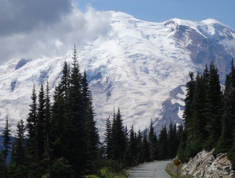
The immensity of Mt Rainier dominates the landscape from every approachable vantage point.
After connecting up with US-12 in Yakima, we entered the park’s east border via state highway 410.
The 14k+ mountain also dominates its national park. Within the park, it is not possible to traverse around the mountain by car. Getting from one area to another takes time and planning.
After much research, we chose White River Campground located more centrally within the park along the northeast facing slope.
White River Campground
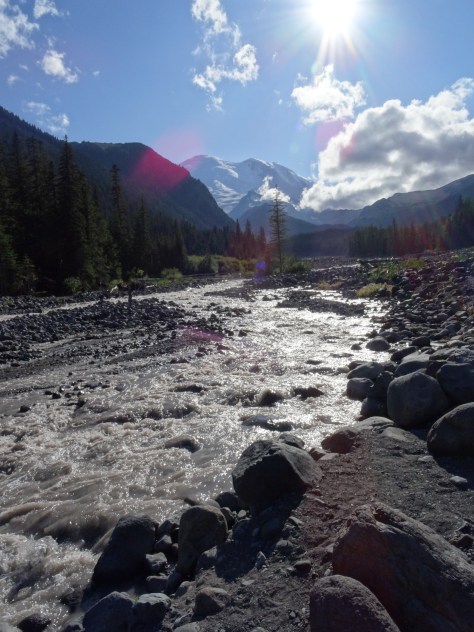
White River offers convenient access to the hiking trails that attracted us. Plus, it sprawls along the bank of the White River, a raging storm of a river furiously fed by three glaciers.
We loved the non-stop sound of water forcing its way down Rainier’s slope, tossing boulders out of its way.
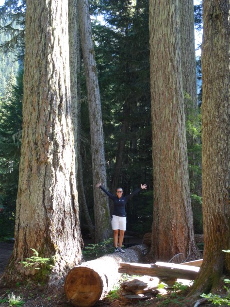
Excitement could not be contained at the sight of these giant Douglas firs!
Because White River campsites are issued on a first-come-first-serve basis, we had a “Plan B” reservation at a campground an hour and half away in the southern end of the park. We were able to cancel that reservation after securing site D17…
Loop D, Site 17 – White River Campground
located directly across from the Glacier Basin Trailhead and a short walk to the Wonderland Trail.
The nearest supply and grocery store is 25 miles away in the community of Greenwater.
Greenwater Outfitters — good coffee, breakfast and deli style sandwiches.
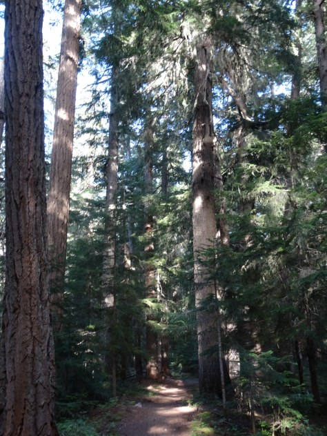
Glacier Basin Trail
From our campsite, we followed Glacier Basin Trail into a thick grove of fir trees and past numerous creeks and waterfalls.
Glacier Basin Trail
Just shy of a mile, we veered onto the Emmons Moraine Trail: a one-mile (roundtrip) excursion overlooking Emmons Glacier and a beautiful glacial lake.
Glacial Lake below Emmons Moraine Trail
Instead of trekking the additional 2.2 miles to Glacier Basin, we headed back to camp for lunch and a nap (I was fighting a cold).
Trey on the Emmons Moraine Trail
Re-energized, we hopped on our bikes and coasted downhill for six miles, past the Ranger Station to Highway 410. In hindsight, we both agreed the roundtrip hike to Glacier Basin would have been easier than the steep ride back up to our campsite.
Henry Weinhard’s Private Reserve – NW Style Lager
Sunrise Area & Wonderland Trail-North
Sitting more than 2,000 feet above the White River Campground, Sunrise has a restaurant, lodge and visitor center. It’s accessible by heading north (away from the river) on the Wonderland Trail for three miles, a strenuous hike due to the rise in elevation.
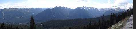
We opted to drive since we’d planned to hike some of the area’s many trails. Sunrise Park Road climbs up from the campground access road, through a series of sharp curves, switchbacks, and outlook points. Gorgeous drive! It provides many photographic opportunities of Mt. Rainier and its surrounding mountains, valleys, and glacial lakes.
Sunrise Lake, from Sunrise Park Road
Sunrise has ample hiking options for every level. From Sourdough Ridge we headed west to Frozen Lake…
Mart at Frozen Lake
looped south around Sunrise camp and Shadow Lake, then caught the Wonderland Trail back up to the Sunrise parking area.
The loop provided varied hiking environments, conditions and wildlife experiences.
Wonderland Trail-South
The Wonderland Trial encircles Mt. Rainier for 93 miles across varied terrains and elevations. It is a popular trail for fit and fervent thru-hikers.
Wonderland Trail Bridge Crossing the White River
With our tent and camping gear broken down and packed away in the “Escape Mobile,” we had yet to brave crossing the “bridge” over the White River to venture southward on the trail.
Trey went first.
Since we lacked the time and transportation to one-way hike to an access point along the campground road, we hiked only about 1/2 mile in before turning around and departing the campground.
Mt. Rainier stands out as a highlight among our camping adventures – it was our first experience among glaciers, and is a truly majestic towering beast of a mountain.
After grabbing dinner at the Old Town Café in West Yellowstone, we gassed up the “Escape Mobile” and headed north to connect with U.S. 287 — a highway we had traveled countless times across north Texas, but never across Montana.
Hands down, the Montana portion is more interesting and beautifulwhile traversing the east bank of the Madison River, between canyon walls, and along the shorelines of several lakes.
Positioned in the lower western sky, the sun provided great photo opportunities of the lakes. (Photo above is Hebgen Lake.)
A particularly long stretch of a lake prompted our curiosity and called for us to stop at its overlook point. Quake Lake had been formed exactly fifty-five years prior when the combination of an earthquake, massive landslide, and subsequent rushing, rising water flooded the valley.
Just minutes after the quake and slide, the new lake began forming. In the following weeks, it grew to encompass an area five miles long and 190 feet deep.
The formation of the lake came at a great cost – twenty-eight people died the evening of the earthquake, either by drowning or being crushed in the landslide.
For Trey and I to be the only individuals standing above the former campground on the 55th anniversary date of its tragic demise, was surreal and humbling.
Dead silver treetops emerge from Quake Lake as an eerie reminder of the past.
Before continuing the drive to Butte, where we would spend the night, we said a short prayer in honor of the lost souls.
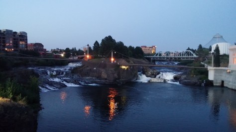
Spokane, Washington
The 316 mile trip from Butte to Spokane…included a seventy-four mile trek across the top of Idaho.
As we approached Idaho, the trees grew dense, steep ravines began crossing under Interstate 90, and fall colors dotted the hillsides.
We were in Idaho just long enough to realize we should have planned a stay there. Next time.
After settling into a hotel on the outskirts of Spokane, we headed downtown for dinner and a walking tour of the city. Spokane was a pleasant surprise because we had no expectations. No thoughts whatsoever, other than a place to sleep for the night. I think perhaps its location in eastern Washington, and its lack-luster name, conjures up images of dust and doldrums.
Spokane is the opposite — lively and lovely. The Spokane River runs through the city’s center. A river walking path was being extended as a part of a larger Riverfront Park renovation plan.
Part of Spokane’s new river-walk and Riverfront Park revitalization efforts
On to Mt. Rainier…
We stopped at a lookout point outside of Vantage, Washington to bask in our first sight of the immense Columbia River. Ginkgo Petrified Forest State Park lay just beyond the opposite bank and was once home to the Wanapums, an indigenous, peaceful tribe of fishermen who are near extinction.
Old Stagecoach/Mail Route
A few hours after crossing the Columbia, and after refueling both the car and our bodies in Ellensburg, we soon caught our first glimpse of the mammoth Mount Rainier. The sighting renewed our energy and enthusiasm for the remaining two hour drive to our campsite.
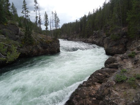
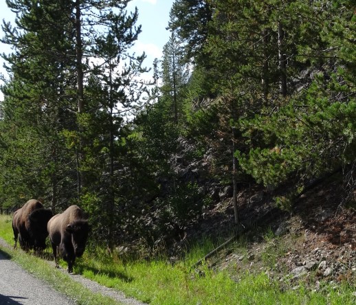
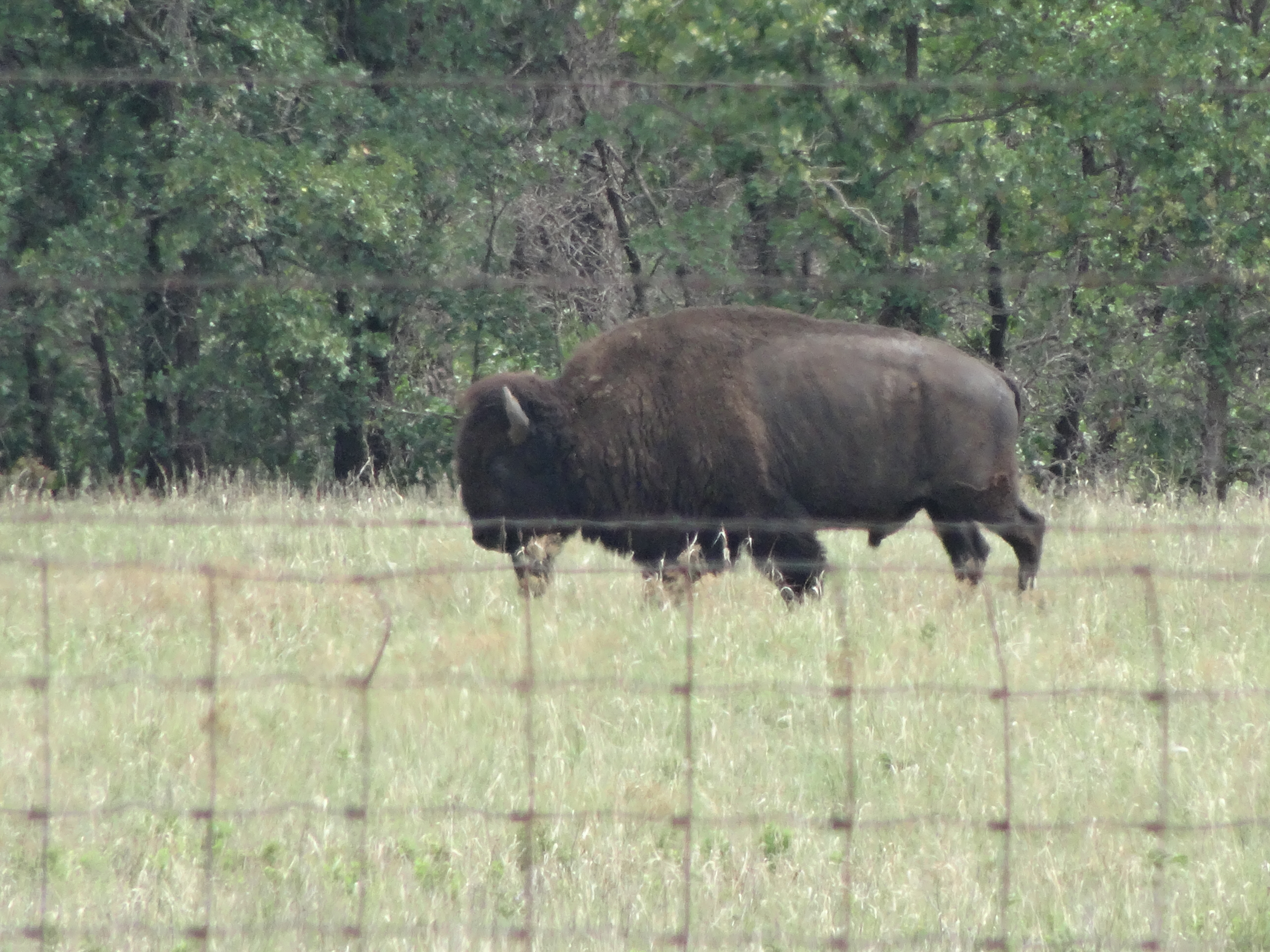
Upon entering Yellowstone National Park’s northeast entrance (located on the Montana-Wyoming border) we were greeted by Buffalo, and more buffalo escorted us throughout the 85 mile drive to the Grant Village Campground.
First stop along the trek was an overlook view of Tower Fall, the famous 132 foot waterfall of the Yellowstone River.
Tower Fall, Yellowstone River (namesake taken from the surrounding rock spirals)
The overlook sits at the junction of the Yellowstone River and Tower Creek which also permitted us to experience the strength of the water forcing its way through the canyon.
Convergence of Tower Creek and the Yellowstone River south of Tower Fall
There is no shortage of wonders along Grand Loop Road which wends through the heart of Yellowstone and around the north shore of Yellowstone Lake. For this reason, the two-and-a-half hour drive took us about four hours, getting us to our campground with just enough daylight to set up camp and grab dinner at Lake View Cafe.
Yellowstone Lake @ Sunset
Grant Village Campground
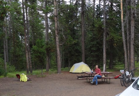
Grant Village is located in the southern end of the park on the “west thumb” of Yellowstone Lake, and within the volcano’s caldera. Our third experience camping, and our third experience pitching our tent in the rain.
Grant Village Campsite, Loop K #391
What a great camping experience! Our site, 391 on Loop K, was spacious and sits near the ledge of a shallow ravine.
Yellowstone is wild, and camping provides a great opportunity to experience that wild. On several nights we were awakened to the howls and barks of wolves running through the ravine below.
The third morning we woke with the sun and to a strange snorting noise outside our tent. A quick look out the window eased our minds – the noises were from two elk cows and four calves grazing just outside.
The calves decided to nestle down in the grass around our tent and keep us company through breakfast.
With everything one would need from restaurants, showers, a post office, and general store, Grant Village is truly a village. We particularly enjoyed exploring the campground by bicycle and the Ranger’s educational presentations at the visitors’ center.
We learned:
Yellowstone’s supervolcano incurred three major eruptions over the past 2.1 million years, and it’s doubtful another one will take place within the next 10,000 years.
Grizzlies’ forage after dark in the summer months and during the day in the spring and fall.
The native lodgepole pine tree has a second type of cone that opens only under the extreme heat of fire assuring the species’ survival
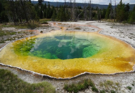
Thermal Geysers
There are more than 10,000 thermal geysers in Yellowstone, and Trey attempted to see them all! Kidding, but at times it seemed as if that was his goal.
Of course Old Faithful was a must-see, and due to its southern location, it was our first stop.
Old Faithful erupting on schedule
Most of the geyser touring areas line Highway 191 on the park’s west side. Raised boardwalks varying in distances from a quarter mile to two miles cut between geysers and keep visitors safe from the unstable, scalding hot ground.
Sapphire Geyser
While visiting each geyser area was impossible over a five-day period, we exhausted ourselves checking out Old Faithful Basin, Biscuit Basin, Fire Hole Loop, and Norris Geyser Basin.
Morning Glory Geyser
Grand Teton National Park
Grand Teton’s north entrance is located 54 miles south of Yellowstone’s Grant Village which made it ideal for a day trip. After checking out Lewis Falls, we headed out of Yellowstone via the John D. Rockefeller, Jr. Memorial Parkway.
Lewis Falls, Yellowstone
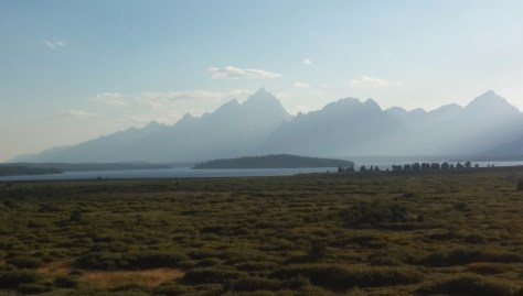
Snake River, Wyoming
The Parkway follows the Snake River and then Jackson Lake, with the Tetons laid out along the other (west) side of the lake.
The day was spent mostly touring the park in the “Escape Mobile.” There is much to see by car including Signal Mountain, which offers great vantage points for both the Tetons and the Snake River Valley to the east.
Looking east from Signal Mountain
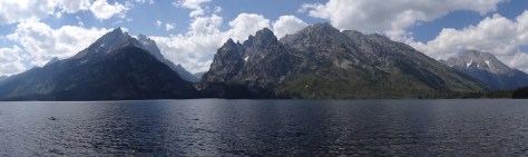
The initial plan was to hike around Lake Jenny, but we decided to explore more of the park rather than spend the day on a 7-mile hike.
A short, but steep, hike to Jenny Lake’s edge, we arrived just as a swimmer made it across from the west side. (his arm is visible in lower left of photo)
As an alternative, we chose the shorter Taggart Lake-Beaver Creek Trail, a 3.8 mile loop. Instead of looping, we hiked about a mile-and-a-half in and backtracked. The trail offered gorgeous shots of the Tetons.
Tetons from Taggart Lake-Beaver Creek Trail
A lovely day that we ended with a fabulous dinner at the Jackson Lake Lodge, donated to the park by JD Rockefeller, Jr. Despite being under-dressed in our hiking clothes, we were seated at window table with a prime view of the Tetons.
Buffalo Chocolates
Moose butter
Vegetable Wellington
Great food! Afterwards, we stepped outside and onto the Lunch Tree Hill trail for a short hike up a ridge overlooking the valley and Grand Tetons. Trey was hoping to see moose, but the sun set while we waited.
Leaving Yellowstone
Having depleted most of our energy, we opted to pull up stakes in Yellowstone a day early, breaking up the 500+ drive to Spokane. We toured another geyser basin on our way to the west exit, where we were escorted out by more buffalo.
Note, though visiting Yellowstone in mid-August, we kept our jackets handy at all times. The evening temperatures fell into the 30’s, and some afternoons brought sudden, but short-lived, storms and hail.
Adirondacks Park is large — 6 million acres, in fact, and although it is a designated protected area by the State of New York, it is not a state administered park. Instead, the hundreds of campgrounds scattered across the park are individually run either privately or by various public entities. The park’s lack of having a central authority and website made researching where we wanted to camp within the 6 million acres challenging. Not that there’s a lack of information on the internet; there is tons of information across numerous websites that we found a bit overwhelming.
We knew we wanted a semi-secluded lakeside campsite close to hiking trails. After many hours of research spread over several weeks, we settled on Little Sand Point located in the south-central part of the park. Its website included a couple of picturesque lake photos and one of a campsite. The description of the campground included the words “serenity”, “nestled” and “secluded.”
To get there, we chose a 150 mile driving route from Plattsburgh, New York that entered the park from the north and took us directly through the middle of the park, along several lakes and through numerous small towns — we were surprised at how rustic and isolated some of the communities seemed. Although the road was a bit rough for having bicycles on the back, it was a lovely drive. It is easy to imagine the area as a giant beautiful bouquet of color in the fall.
We arrived at the Little Sand Point campground about 5 p.m. to find that campsites were about 100 feet off of the main highway and that our site was located directly below where the campground’s dirt road turned around. There were car tracks where someone had missed turning that led directly to where we were to pitch our tent! Although our site was directly on beautiful Lake Piseco, it was also located next to a house with a barking dog and an upset baby. The campground was mostly vacant so we walked through other sites looking for a better option. We found no site with a level tent area, decent fire pit, nor any that were “serene” or “nestled.”
After about 45 minutes of weighing our best options and trying to be positive about this campground, we climbed back into the Escape Mobile and headed north. Our plan was to stay in Lake Placid unless we found a lodge or cottages along the route where we felt we’d be comfortable.
Lake Placid, New York
We arrived in Lake Placid about 9:00 p.m. with no place to stay. Trey cruised Main Street a couple of times looking for vacancy signs while I searched from my phone. Out of frustration, we pulled off of Main into a parking lot and connected a laptop to our mobile Wi-Fi. Initial results for the few name brand hotels were well over budget, and, I suspect due to the late hour, calls we made to locally owned lodges were not answered.
Just as I began to worry about our situation, I was startled by a sudden knocking and the appearance of a disheveled man at my passenger side window. A better look at his face revealed that there was no need to worry and I rolled down the window. In a British accent he asked us if we needed help. I explained that we were just looking for a place to stay. Turns out, the parking lot was for a lodge, Wildwood on the Lake, and was owned by the family of the gentleman’s wife – he handled maintenance and supervised the cleaning staff. He had just stepped outside to make sure something was locked when he spotted us.
He stated that he had a couple of rooms available, that he would ask his wife to reopen the office, and that they’d give us good deal. This is just one example of several on our North America travels where the solution found us – when and wherever we had a significant need, the universe quickly responded.
We were most grateful, and ended up spending three restful nights on the bank of beautiful Lake Placid. The inn was rustic, quiet and clean, and its stretch of shoreline more than provided the peaceful lakeside experience we had sought.
View of Lake Placid from the back of WIldwood Lodge
Lake Placid’s Main Street is the city’s business and tourist center and runs along the west bank of Mirror Lake – not Lake Placid.
Main Street, Lake Placid, New York
Although Lake Placid is nearby, it is the much smaller Mirror Lake that is the hub for water related recreation, lakeside dining and accommodations.
Trey had no luck with the fish in Mirror Lake
We enjoyed strolling and window shopping along Main Street. This charming city is a mix of early 20th century buildings at its center, bookended by expansions resulting from the 1980’s Winter Olympics economic boost.
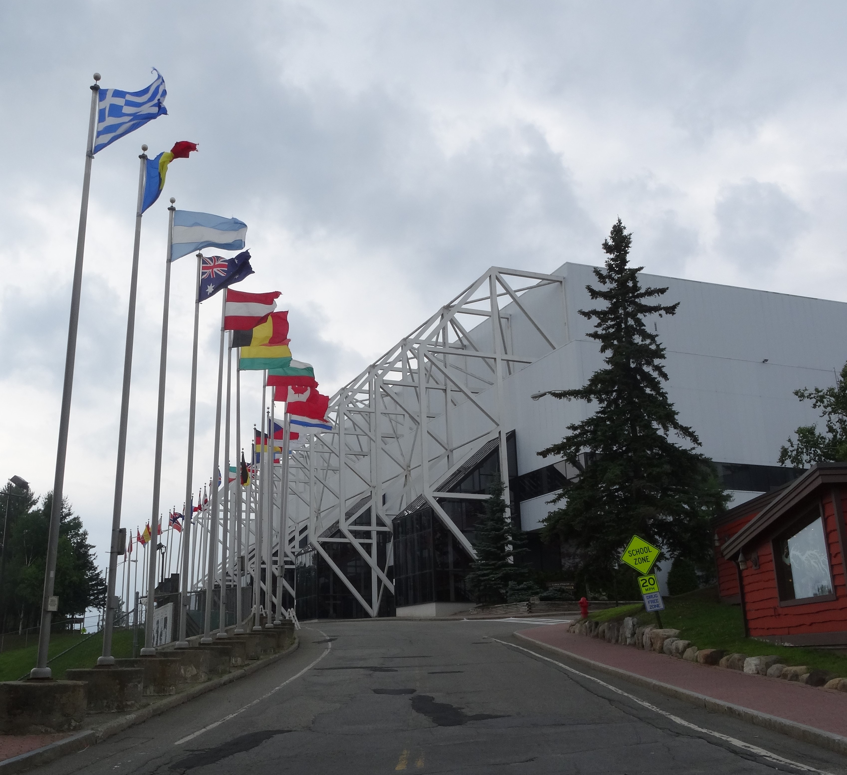
Both the 1936 and 1980 Olympic Centers sit at the south end of Main along with the outdoor skating area where Eric Heiden won five gold medals for the U.S.
Olympic Center, Lake Placid, NY
The original 1936 center is now a museum commemorating both the games.
Original Olympic Center, Lake Placid, NY
The village now hosts an annual Iron Man competition. This was the cause for our difficulty in finding accommodations. Athletes were beginning to arrive to acclimate and train for the July 27th race.
Recreation
Trey heading out to fish on Lake Placid – caught a small bass
One afternoon we rented a canoe and slowly paddled around the perimeter of the Mirror Lake — two swim lanes had been set up in the middle of the lake for the Iron Man competition and several swimmers were using them.
When we completed our circle the sun was low in the sky and the other watercraft and swimmers were heading to shore. We instead headed to the middle point of the lake to get check out the swim lanes. Soon after, we found that we were alone on the lake – it was entirely ours. A gift.
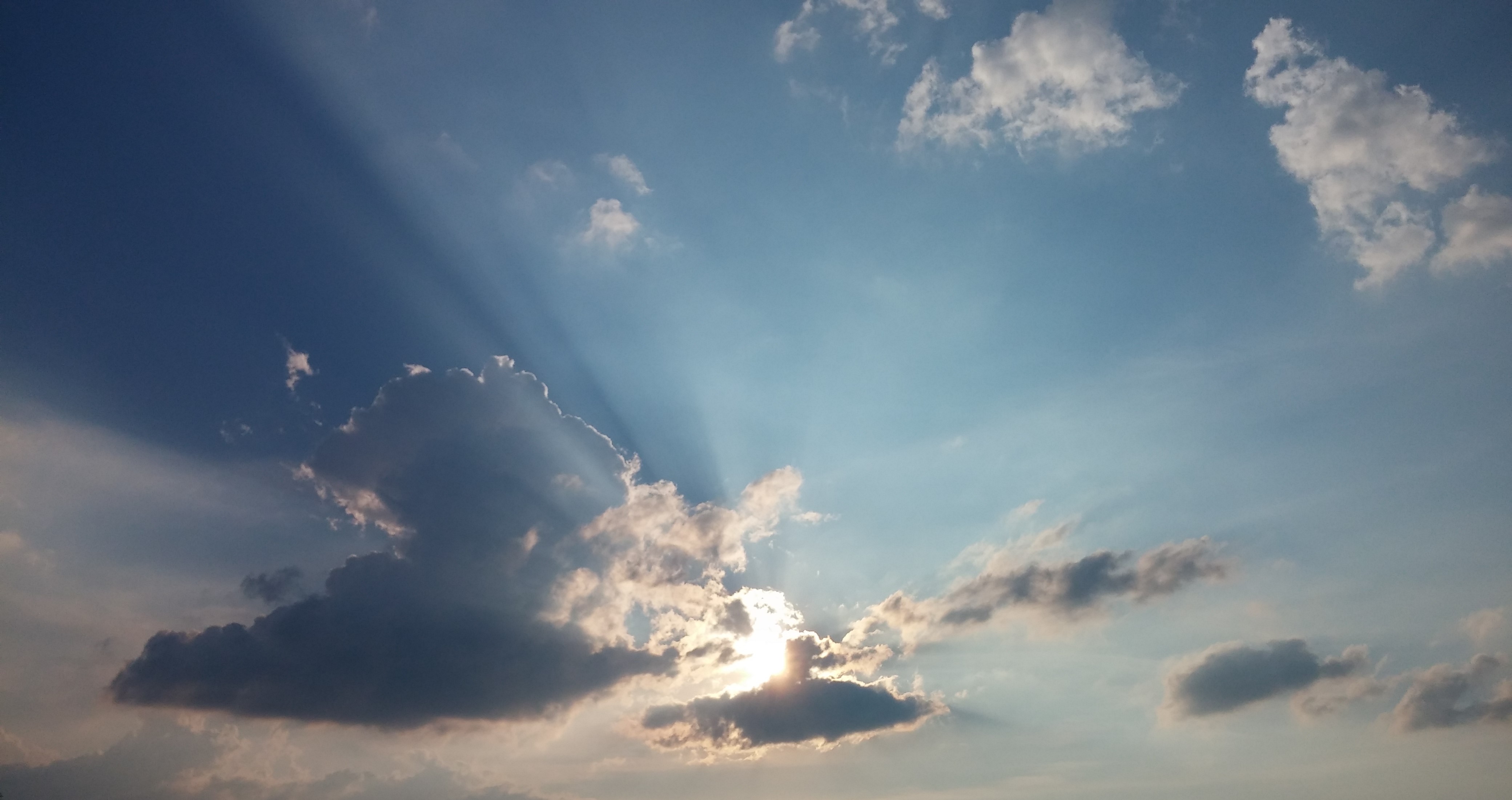
Sun beginning to set on Mirror Lake
As stated in the “About” page of this blog, Trey and I both were responsible for the care of our ailing parents. Over a period of 10 years from April of 2001 to August of 2011, we did our best to ensure they were safe, well cared for, and maintained the best quality of life possible despite their various diseases. The latter part of this period was particularly stressful. A frequent fantasy of mine was to row a canoe out to the middle of a calm, empty lake and simply lie down in the canoe, look at the sky, and in that moment be responsible for nothing.
Trey snapped this one of me enjoying the serenity of Mirror Lake
I have learned when one receives a gift, it should be embraced and appreciated fully. So, I laid down in the canoe, and simply admired the sky, feeling so very grateful for the peace that I now enjoy.
As for Lake Placid, we also experienced it via the Peninsula Nature Trails that wind through a landmass on the southern part of the lake. The trails provide a wonderful natural retreat within walking distance of the city.
Lake Placid’s Peninsula Trail
The trails’ access point is not well marked – it is simply an unmarked road that appears to be a driveway and is located between the Comfort Inn and Howard Johnson’s restaurant.
The Village of Lake Placid is a bit off the beaten path, particularly for us Texans, but it was a wonderful refuge and allowed us to experience the beauty of the Adirondacks.
Main Street, Lake Placid, New York
Food
My favorite Lake Placid meal was enjoyed at Milano North. It was well out of our budget but at least we were satisfied that we received what we paid for. Milano North provided a comfortable, but upscale setting and, for me, the best formal fish dish experienced on our trip.
Baarramundi with Coconut Rice, Milano North, Lake Placid, NY
Trey preferred the spaghetti and meatballs at Jimmy’s 21, which offers an affordable and quality dining experience on Mirror Lake.
The Breakfast Club is a popular breakfast spot and we found that the food was well worth the wait we encountered on both of our visits — yes, it was good and reasonable enough to merit a return trip.
Trey and I had heard from multiple sources that Acadia National Park was one of the most beautiful national parks in the country, so it was one of the first destinations that came up in discussions as the possibility of our travels began to evolve.
We arrived from Boston at the park’s Seawall Campground in the early evening, just as a line of rain that was preceding Hurricane Arthur caught up with us. Seawall is a popular walk-in campground located in the southwestern part of the park. I was glad we had made reservations as the campground was completely full despite the weather.
Acadia, Seawall Campground
It was our second camping experience, and the second time we pitched the tent in rain. By sunset, the rain had strengthened and there was nothing else to do but crawl into the tent and call it a day. We were awoken three hours later – Arthur, now a tropical storm, had officially arrived. Gratefully, our campsite was in a bit of a valley and well shielded by tall pines.
Acadia campsite in the rain
Maine’s early sunrise took both Trey and I by surprise. I guess if we’d thought about it, we should have expected sunrise by 5 a.m. or so, but no, we were not prepared for Maine’s 4:00 a.m. sunrises.
We left camp about 7:00 a.m. to head into town for breakfast and to stock up on camping supplies. That was when we realized Arthur’s true fury – we ran into a large fallen pine tree on the foot path leading to the camp parking lot along with dozens of downed branches. We encountered the same scenes driving through Southwest Harbor.
The island where Acadia National Park is located, Mount Desert Island, is mostly divided in half down the middle by the Somes Sound, which leads into the Atlantic Ocean — the island looks a bit like a pair of lungs. As there are no bridges that cross the sound, we had to detour about an hour around the left, or west, lobe of the island in order to leave it because a large fallen oak tree had completely cut off access to the main road. The drive to Ellsworth for groceries and supplies was another hour, so this simple task ended up taking up most of our day. It was fine though because not much of anything else could have been accomplished on the dark grey, windy, rainy day.
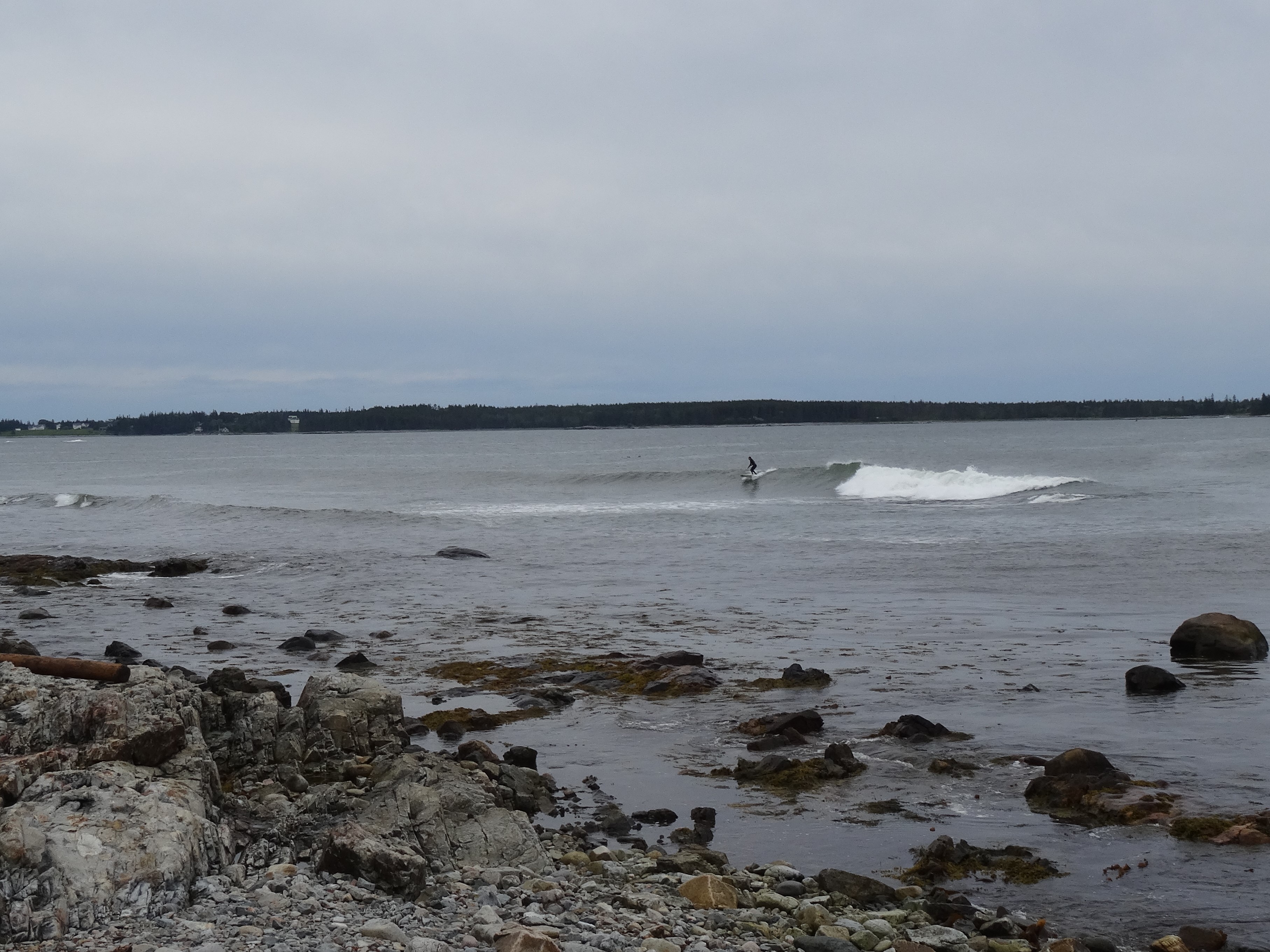
When we finally returned to camp, the rain had turned into a drizzle and the remaining daylight allowed us to explore the campground and its surrounding trails. We headed to the seawall and watched some brave surfers taking advantage of the high waves.
Surfer at Seawall Picnic Area
We walked out onto the rocks and admired the beauty of the northeastern coast line – the sight, we had longed to experience, did not disappoint.
Seawall, Acadia National Park
Sunday morning’s beautiful blue sky and bright shining sun was a much welcomed sight and gave us renewed excitement and energy for exploring Acadia.
Southwest Harbor near Seawall Campground
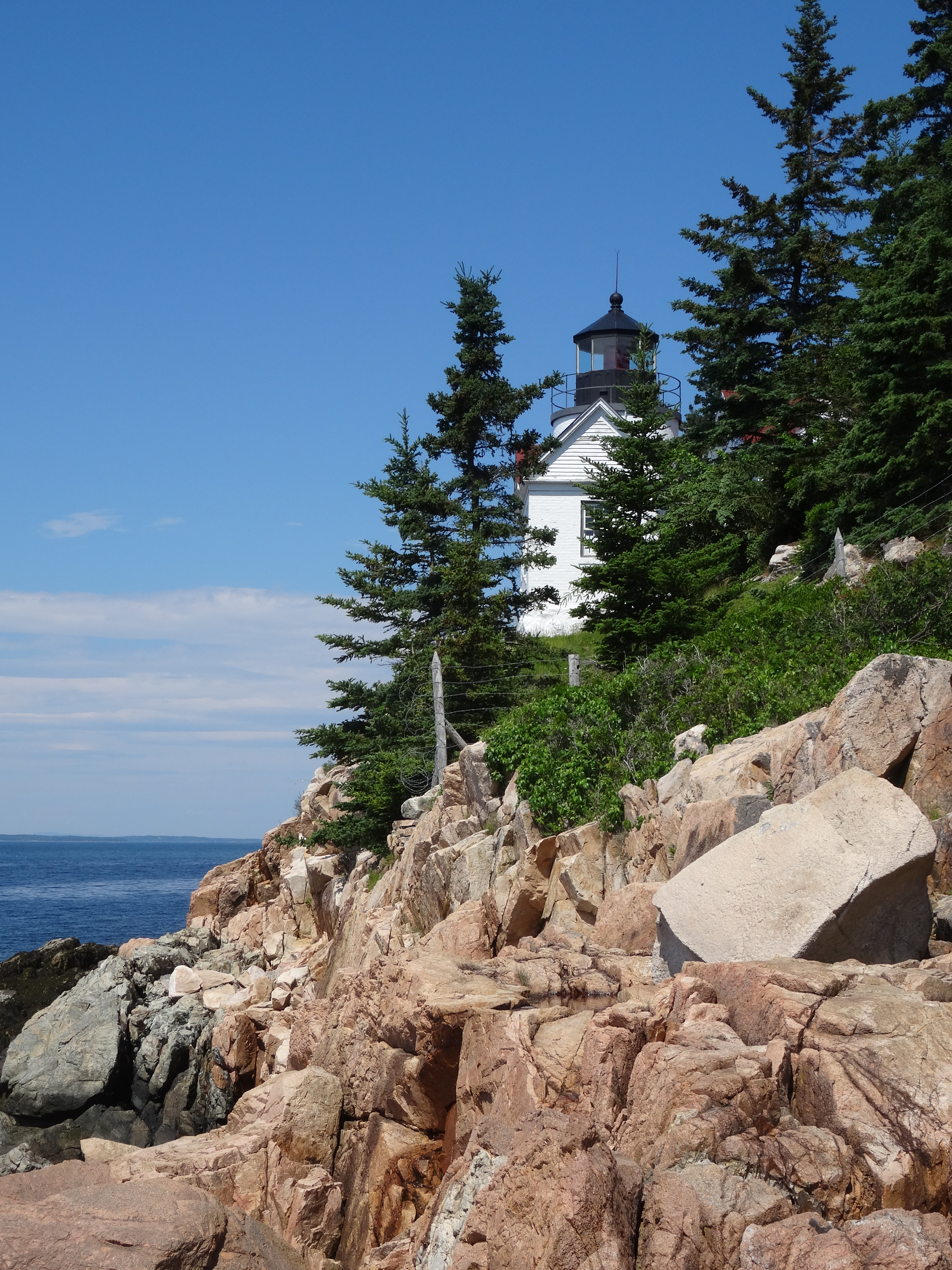
We first backtracked past our campsite to check out a light house that we had noticed on the island detour from the previous day. Bass Harbor Head Light is the official name, so I guess does not merit being called a “light house” due to its small size.
Bass Harbor Head Light, 1858
We were excited nonetheless, as it was the first such light structure we had both experienced up close, and we thought it looked very stately and noble looking out over Bass Harbor where it has guided vessels since 1858.
Carriage Roads
With bikes in tow, we then headed to the eastern lobe of the island where 45 miles of roads accessible only by foot, bicycle or horse were constructed from 1913 through 1940 through the philanthropic effort of John D. Rockefeller, Jr.
The numerous interconnecting roads wind around lakes, through valleys and near coastlines of eastern Acadia.
Trey leading the way on one of Acadia’s carriage roads
We selected a 13-mile route that would take us up to the northern coast of the island, loop southward crossing our starting point and then completing a figure 8 by looping further south around Eagle Lake.
Duck Brook Bridge, North Carriage Road, Acadia
It was a perfectly beautiful day and the roads led us to gorgeous vistas of the Maine coast, along raging creeks, across impressive stone bridges, and up and down the hills surrounding Eagle Lake.
Beaver haven along the carriage road
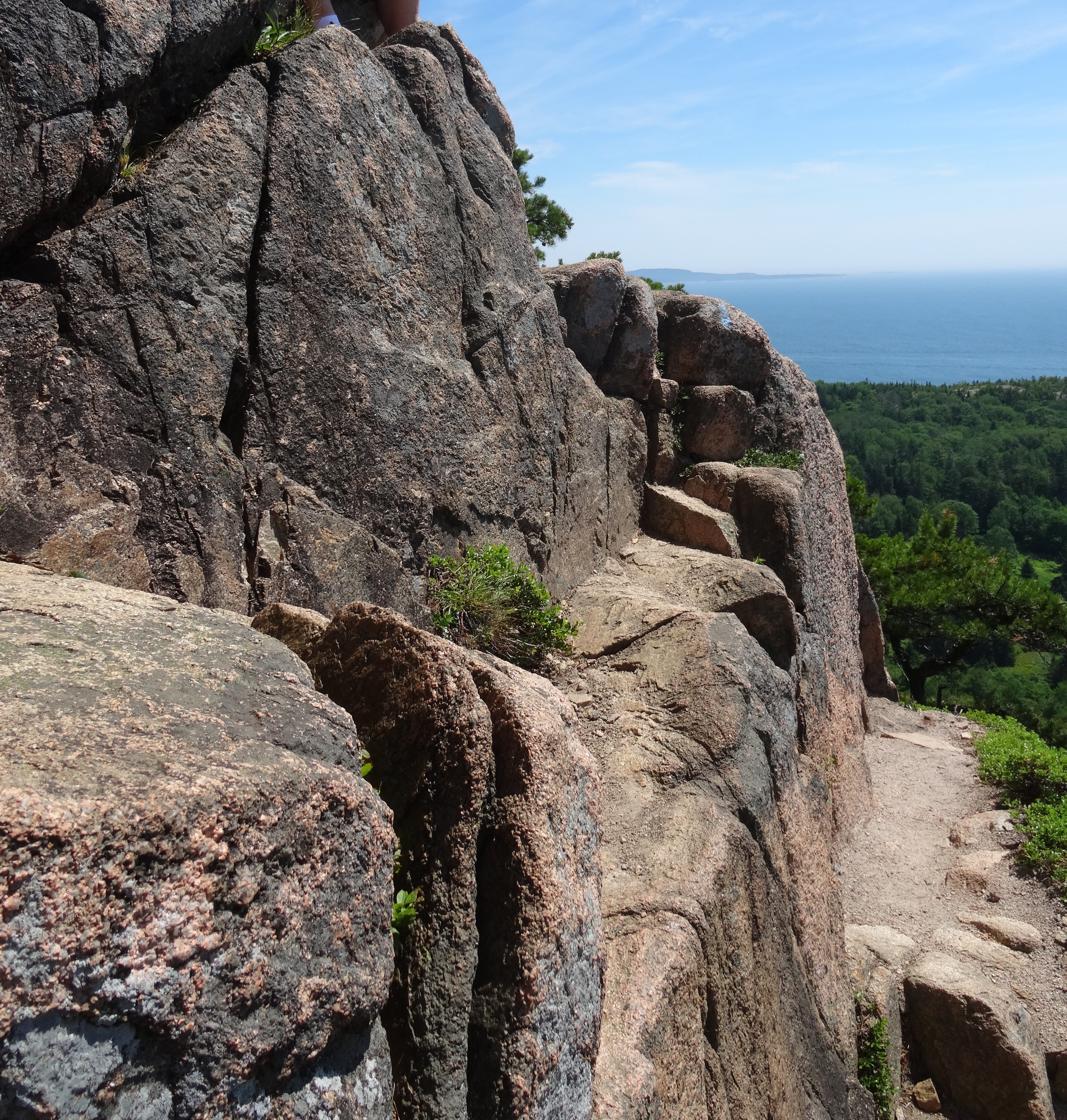
The Bee Hive
In May, prior to our travels, Trey had to have some minor oral surgery and when he told his surgeon of our plans, the surgeon told Trey of two “must do’s” – the first was to hike the Bee Hive trail in Acadia National Park, and the other was to drive up to the summit of Mount Washington in New Hampshire. He’d warned Trey that it was a strenuous hike and required climbing up rails that had been embedded into the rocks, but he also stated that the views were well worth it.
So we again headed to the east lobe of the park, this time taking Park Loop Road, a scenic one-way route along the eastern shoreline that loops around the south shore, then northward through the middle of the park.
The Bee Hive trail head is on the eastern shore above Sand Beach. The hiking trail immediately headed upwards over rocks and through pines, and at times it was difficult to know if we were still on the trail due to all the rock.
View of Sand Beach from the Bee Hive Trail
After about a quarter of a mile however, the path narrowed and trail markers started pointing us upwards…and up…and up.
Beehive Trail, Acadia National Park
A particularly narrow pathway that towered over a rocky cliff had me shaking a bit, but we had gone far enough at that point that there was no turning back as people were coming up behind us and there’s only enough room for one person to pass on the hand and foot rails.
Beehive Trail, Acadia National Park
The vistas of the eastern coast line and of Bar Harbor, Maine were amazing, and I felt quiet accomplished once we safely reached the summit, which is only a mere 520 feet above sea level.
Glad to have made it to the Bee Hive summit!
After catching our breath and a quick snack, we continued on a much easier trail that led down to a small lake. Bowl Lake looked much like the glacier lakes found in the mountains of New Mexico and Colorado.
Bowl Lake, Acadia National Park
We followed the path around about a quarter of the lake, and then headed around the base of Bee Hive “mountain” and back to Sand Beach.
Cadillac Mountain
Following our hike, we continued driving around Park Loop Road stopping occasionally to take in the views of the Atlantic Ocean.
Thunder Hole, Acadia National Park
The road provides the only car access (there are several hiking trails) to Cadillac Mountain, the highest peak in Acadia at 1,530 feet.
There is a paved path at the summit that provides panoramic views of the park and coastlines.
Maine Coastline
The summit’s geography of rolling pink granite reminded us immediately of the Texas Hill Country (see feature photo at the top of this post).
View from Cadillac Mountain, Acadia National Park
We ended the day, our last in the beautiful State of Maine, with a lovely Italian dinner in Bar Harbor. A quaint, but touristy, city on the northeastern shore of Mount Desert Island.
Bar Harbor, Maine
Food
The town of Southwest Harbor has several good eating options. We particularly enjoyed Little Notch Pizzeria, which has a menu that extends well beyond pizza, and for breakfast, the omelets at Eat-a-Pita are amazing.
Ben & BIlls Chocolate Emporium in Bar Harbor has a huge selection of homemade ice cream that includes unique flavors such as margarita, coconut macadamia & KGB (Kahlua, Grand Marnier & Bailey’s with fudge swirl). We also loved their homemade dark chocolate clusters.
Best Ice Cream in Maine, Bar Harbor, Maine
We had high expectations for Acadia National Park based on everything we had heard, and we both agree that those expectations were exceeded. Acadia has definitely been a highlight of our travels, and comes up consistently when we’re asked such questions.
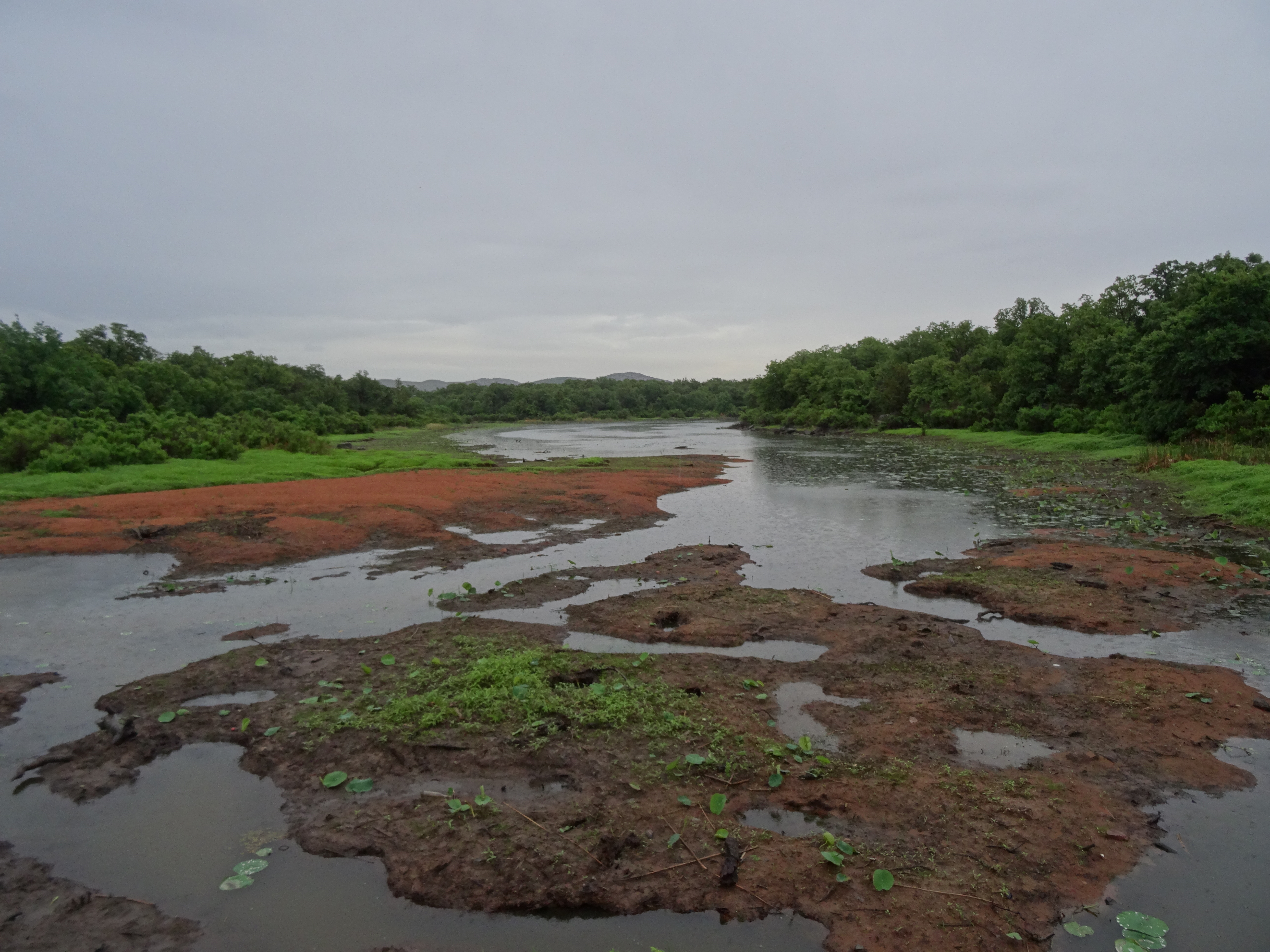
WICHITA MOUNTAINS NATIONAL WILDLIFE REFUGE – May 23-24, 2014
The Wichita Mountains were a favored camping destination for my family when I was a young child and are located about 80 miles north of Wichita Falls, just west of Lawton, Oklahoma.
More than half of the park’s 59,000 acres is a fenced off protected area to allow the white tailed deer, mountain elk and buffalo an environment void of human contact. The remaining refuge, which also has wildlife roaming freely through it, consists of campsites, public hiking trails and a vast wilderness area.
Setting up camp was a bit of a wet experience, but we were able to do so quickly and managed to keep the inside of the tent dry along with our sleeping bags and mats. Despite the rain, the campground was full.
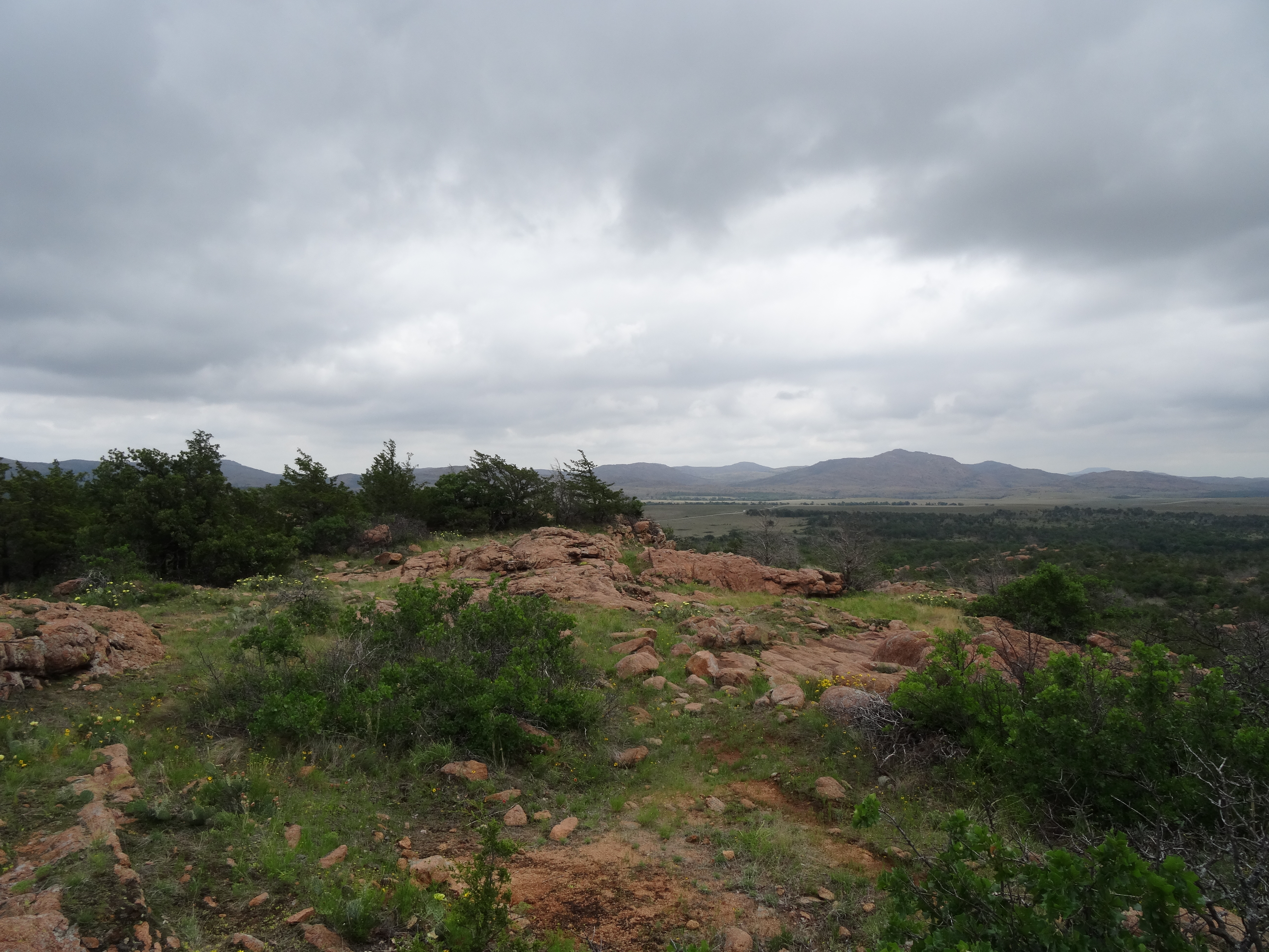
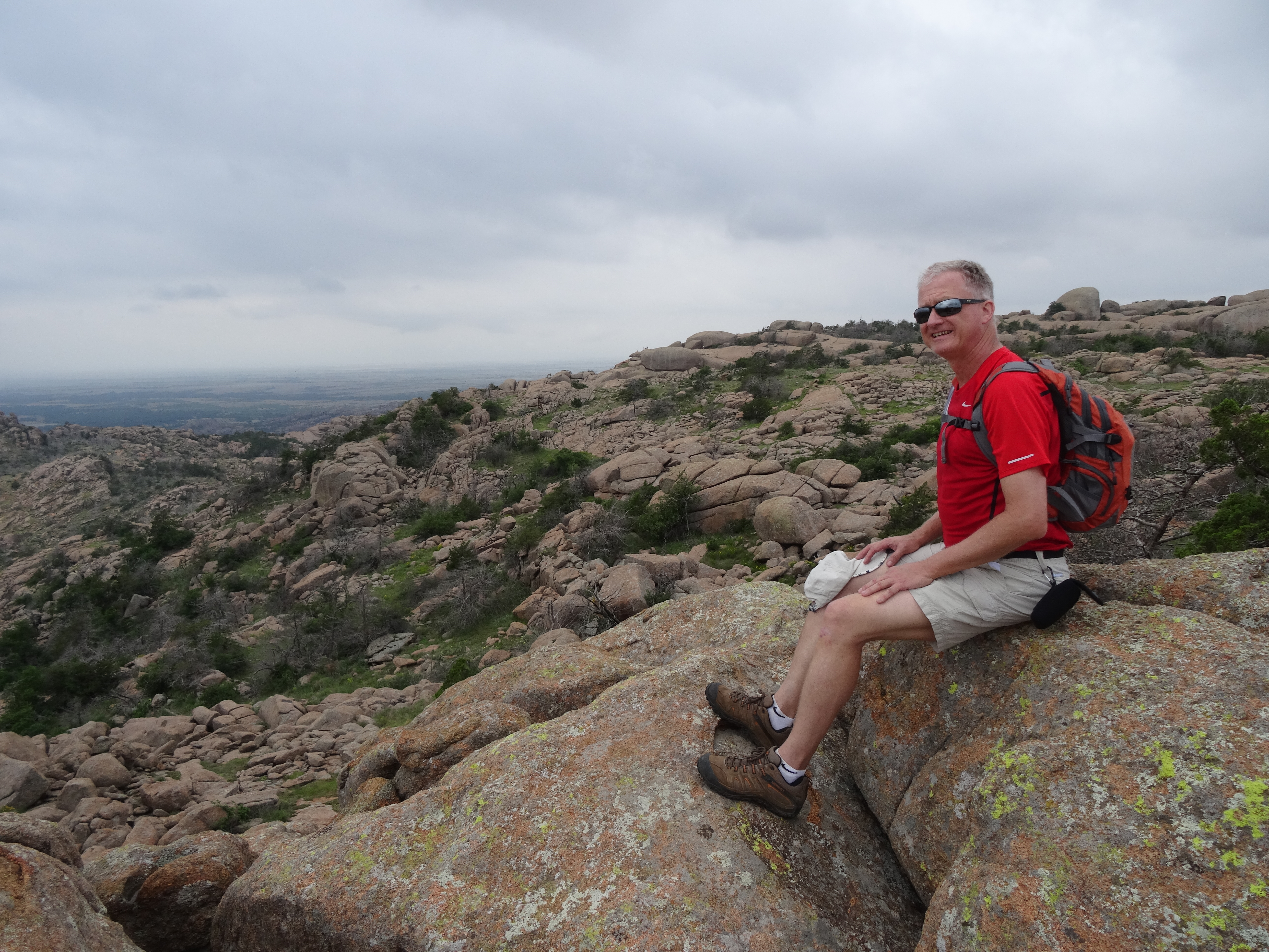
We awoke Saturday morning to unseasonably cool weather and sunshine – it was beautiful! We decided to start the day with a short hike to the top of Elk Mountain. The trail was marked moderate to easy being a rocky, but scenic trail.
The Elk Mountain trail head was at the west end of the park and led into a large designated wilderness area where hiking and backcountry camping are allowed by permit.
The entire “wilderness area” seemed to be visible from the peak of Elk Mountain beginning with a gradual slope of stacked pink granite boulders.
View of wilderness area from the top of Elk Mountain
Trey wanted to venture out on the rocks for a better vantage point. Unsure at first, I mustered up the courage to join Trey, which required stepping over deep crevices between the large boulders that seemed be vicariously sitting on the mountain’s ledge.
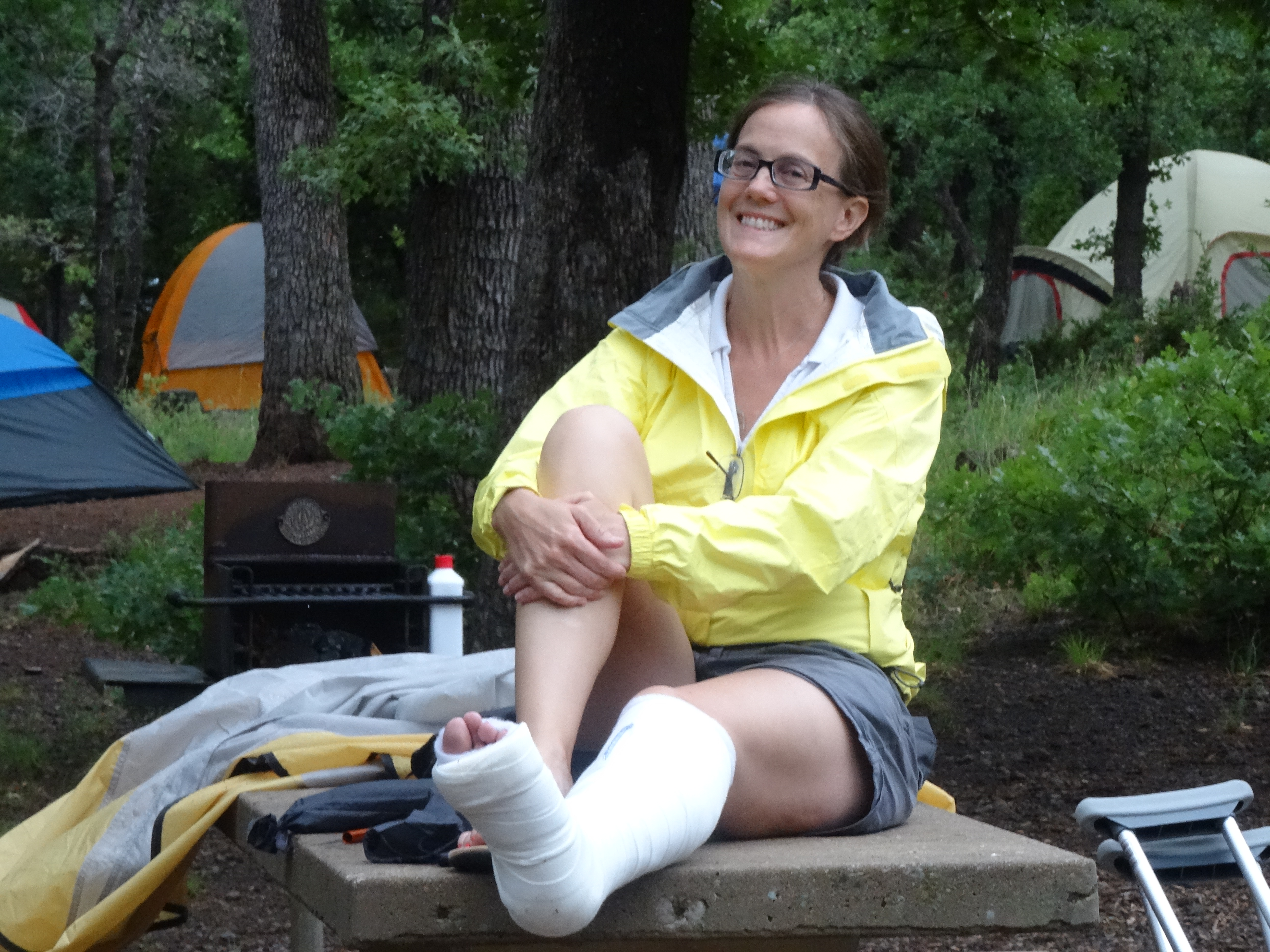
Elk Mountain trail was a great first choice, but unfortunately, was our only hike and adventure in the wildlife refuge. I turned my ankle about ¾ of the way down the mountain. I heard a crack, but convinced myself that it was just a sprain so that I could make it the rest of the way down the mountain – which I did with help from Trey.
An x-ray at a Lawton hospital confirmed a small fracture of the left distal fibula. The advice of the ER physician was to see an orthopedist after Memorial Day.
At that point, we decided it was best to pack up our campsite and get a hotel for the night, and then head to Austin in the morning to seek treatment. We were mostly disappointed that our time was cut short in Oklahoma, as we were very much looking forward to reunions with cousins and exploring Tulsa and Tahlequah.
We made the necessary investments in quality camping gear in April, and had previously practiced setting up our tent in our apartment. It took us about 20 minutes, which was pretty good considering the time we spent trying to interpret the instructions.
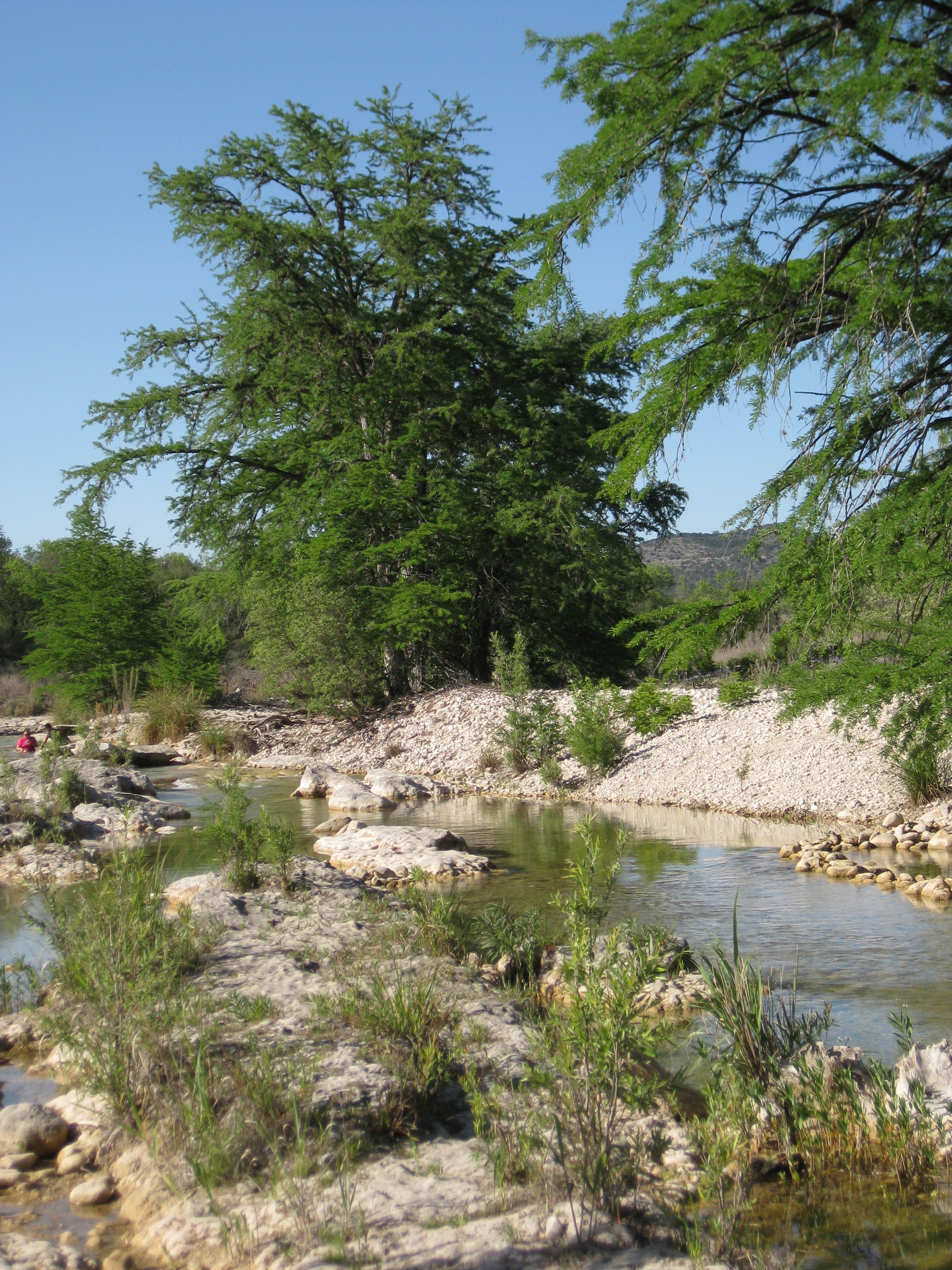
We have lived boarding the Texas Hill Country for a little over 26 years, yet haven’t taken the time to enjoy what it offers as much as we would have liked. With our departure from Texas looming and experience in camping lacking, it was the perfect place for a weekend trial run – convenient, beautiful and included locations that we have wanted to explore.
Our 355 mile Hill Country trek looped from Austin through San Antonio, past the notorious Snake Farm, which has since been re-branded the “Snake Farm Zoo” and seemed to be thriving, perhaps as a result of the Ray Wiley Hubbard song. From San Antonio we headed west to Uvalde County, then north to the small but quaint river city of Concan, which is the nearest city to Garner State Park.
Leaving the park we choose the less traveled route east to Utopia, crossing the dry Sabinal River several times and through what felt like the heart of the Hill Country, with 360 views of steep valleys and rolling hills.
After a brief stop at Lost Maples State Natural Area, we headed northeast meeting up with, and then following, the Guadalupe River through Hunt and Kerrville. We continued northeast to Fredericksburg, a place we had visited several times, so not stopping, but acknowledging the mast-like home of Admiral Chester Nimitz and honoring his historical significance through our thoughts and conversation as we passed.
Like the drive from Austin to San Antonio, the drive from Fredericksburg was a familiar one, but proved to be a fitting send-off gift to us from the Hill Country. Sans bluebonnets and paintbrushes, the wildflowers were very much still in bloom and provided waves of yellow, red, orange, purple and white on each side of Highway 290 through the waning rolling hills toward Austin.
Garner State Park was not as lush as we had expected, and although well aware of the drought, we were both taken back by how little water was in the Frio and surrounding creeks.
After setting up camp and checking out the river, we biked through the park and found it alive with people, food and fun times. We cooked our dinner over the open flame of the fire Trey built — orange honey habanero chicken breast we’d picked up at Central Market on our way out of town, and the leftover beans and jalapeno cornbread I had prepared earlier in the week – a great meal to christen our new camping cooking and dinner ware.
We were told of the traditional Saturday night dance hosted at Garner State Park’s pavilion. So, with the sun setting, we mounted our bikes, turned on our head and seat lights, and headed to the pavilion for the dance. A footpath we found leading from the road led us to the pavilion’s flagstone patio that was serving as the dance floor and Garth Brooks was crooning about Friends in Low Places.
The final big test, at least for me, were the public showers. There was no avoiding them — we were dirty, dusty and sweaty. The important lesson I learned about outdoor showers is to first do a careful 360° examination for shower companions – this should probably actually be done twice as a particular caution. If I had thought to do so, I would have avoided taking a shower with a Texas giant centipede!
Once, safely out of the shower and bathroom, I could joke as I told Trey of my experience. We both laughed and agreed that we are, after all, embarking on these travels for new adventures!
Test camping trip: Success
This is a record of Trey & Martha's 2014 U.S. travel adventures


")


 From our campsite, we followed Glacier Basin Trail into a thick grove of fir trees and past numerous creeks and waterfalls.


 It provides many photographic opportunities of Mt. Rainier and its surrounding mountains, valleys, and glacial lakes.


 Since we lacked the time and transportation to one-way hike to an access point along the campground road, we hiked only about 1/2 mile in before turning around and departing the campground.
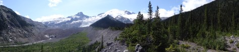

 while traversing the east bank of the Madison River, between canyon walls, and along the shorelines of several lakes.
 Quake Lake had been formed exactly fifty-five years prior when the combination of an earthquake, massive landslide, and subsequent rushing, rising water flooded the valley.


 included a seventy-four mile trek across the top of Idaho.

 The Spokane River runs through the city’s center. A river walking path was being extended as a part of a larger Riverfront Park renovation plan.
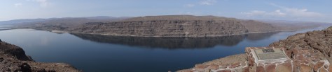 Ginkgo Petrified Forest State Park lay just beyond the opposite bank and was once home to the Wanapums, an indigenous, peaceful tribe of fishermen who are near extinction.

 The sighting renewed our energy and enthusiasm for the remaining two hour drive to our campsite.


![IMG_2803[1]](https://wewillfigureitoutblog.com/wp-content/uploads/2014/05/img_28031.jpg)