Tag Archives: Montana

Drive Between Yellowstone & Mount Rainier National Parks ~ August 17-19, 2014

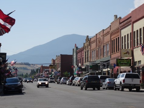
After grabbing dinner at the Old Town Café in West Yellowstone, we gassed up the “Escape Mobile” and headed north to connect with U.S. 287 — a highway we had traveled countless times across north Texas, but never across Montana.

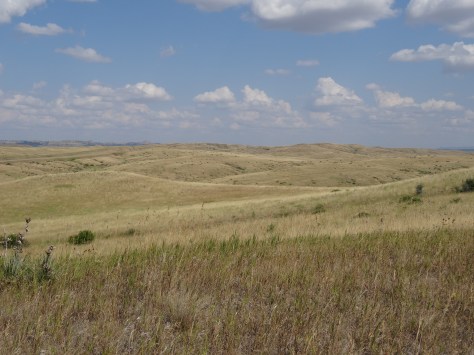
Hands down, the Montana portion is more interesting and beautifulLake Hebgenwhile traversing the east bank of the Madison River, between canyon walls, and along the shorelines of several lakes.

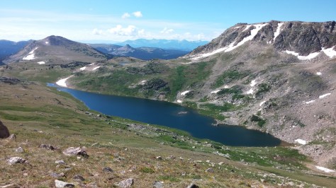
Positioned in the lower western sky, the sun provided great photo opportunities of the lakes. (Photo above is Hebgen Lake.)

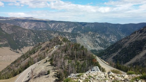
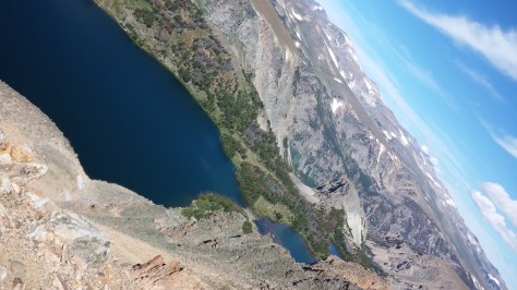
A particularly long stretch of a lake prompted our curiosity and called for us to stop at its overlook point. Quake Lake, MontanaQuake Lake had been formed exactly fifty-five years prior when the combination of an earthquake, massive landslide, and subsequent rushing, rising water flooded the valley.

Just minutes after the quake and slide, the new lake began forming. In the following weeks, it grew to encompass an area five miles long and 190 feet deep.


The formation of the lake came at a great cost – twenty-eight people died the evening of the earthquake, either by drowning or being crushed in the landslide.

For Trey and I to be the only individuals standing above the former campground on the 55th anniversary date of its tragic demise, was surreal and humbling.

Tree tops emerging from Quake Lake
Dead silver treetops emerge from Quake Lake as an eerie reminder of the past.

Before continuing the drive to Butte, where we would spend the night, we said a short prayer in honor of the lost souls.

Spokane, Washington

The 316 mile trip from Butte to Spokane…Montana Landscapeincluded a seventy-four mile trek across the top of Idaho.

As we approached Idaho, the trees grew dense, steep ravines began crossing under Interstate 90, and fall colors dotted the hillsides.


We were in Idaho just long enough to realize we should have planned a stay there. Next time.

After settling into a hotel on the outskirts of Spokane, we headed downtown for dinner and a walking tour of the city. Spokane was a pleasant surprise because we had no expectations. No thoughts whatsoever, other than a place to sleep for the night. I think perhaps its location in eastern Washington, and its lack-luster name, conjures up images of dust and doldrums.

Spokane is the opposite — lively and lovely. Spokane, Wa
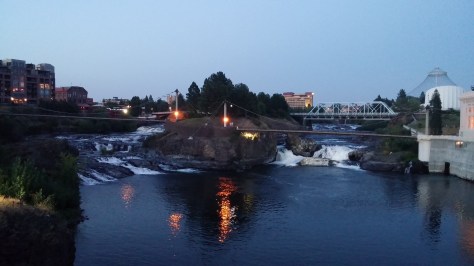
The Spokane River runs through the city’s center. A river walking path was being extended as a part of a larger Riverfront Park renovation plan.

Spokane Riverfront Park Improvements
Part of Spokane’s new river-walk and Riverfront Park revitalization efforts

On to Mt. Rainier…

We stopped at a lookout point outside of Vantage, Washington to bask in our first sight of the immense Columbia River. Columbia River
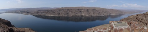
Ginkgo Petrified Forest State Park lay just beyond the opposite bank and was once home to the Wanapums, an indigenous, peaceful tribe of fishermen who are near extinction.


A few hours after crossing the Columbia, and after refueling both the car and our bodies in Ellensburg, we soon caught our first glimpse of the mammoth Mount Rainier. Mt Rainier in the distanceThe sighting renewed our energy and enthusiasm for the remaining two hour drive to our campsite.

Red Lodge, Montana – August 9~13, 2014

We experienced two firsts during our stay in Red Lodge – we saw our first bald eagle in the wild, and we saw our first sign of the coming autumn. Both of these firsts took place while rafting (without a camera) on the Stillwater and Yellowstone Rivers. We had been hoping to spot a bald eagle as they’re pretty common in the area; the changing leaf colors on Aspens and Cottonwoods was a surprise though. It was early August and autumn was arriving. We would follow its arrival from that point across the remaining west and into the northwestern states and Canada. Much like we had followed the hydrangea bloom up the eastern states and into Vermont.

Red Lodge, Montana
Broadway Avenue, Red Lodge, Montana

Red Lodge is a former mining town and retains the rugged charm of its past in the late 19th century brick buildings that line its main street, Broadway Avenue. We stayed in one such building, The Pollard, which claims to have hosted legends such as Bill Cody, Calamity Jane and Harry Longabaugh, a.k.a. the Sundance Kid, who ended up robbing the bank housed on the building’s first floor.

The Pollard Hotel
The Pollard Hotel

There’s not a whole lot to do in Red Lodge other than strolling Broadway’s sidewalks to browse gift shops and scout restaurants, of which there were many. Nightly dinner options were difficult decisions due to the many amazingly good options. We particularly enjoyed Bridge Creek Backcountry Kitchen & Wine Bar and the Carbon County Steak House, where we dined on fresh Alaskan Halibut.

For as much as Red Lodge appears to be the standard western outpost trying to attract visitors with a taste of the past, in actuality, we found it to possess a progressive sophistication. This was evident in the food, the local market and the people making a living there. There was also a yoga studio that offered destination hiking and yoga trips in the mountains that I sadly had to miss. We will have to get back there.

Montana Cover Photo 5

The adventure starts at the city’s perimeter where the Montana wilderness begins. We had received a warm welcome, loads of helpful advice and maps at the visitor’s center on our first full day in Red Lodge and then immediately headed out of town via West Fork Road to a trail labeled as a good “conditioning hike.”

Basin Creek Lakes Trail
Basin Creek Lakes Trail, Trail #61

The Basin Creek Lakes Trail ascends steeply for two and half miles following Basin Creek to a lower lake and then continues for another mile and a half to an upper lake.

We opted to turn around at the lower lake for a total roundtrip hike of five miles. We had started to turn around after about two miles because I was growing more apprehensive as we headed further into the wilderness. We were in the middle of grizzly country and seemingly alone on the trail…bear bait. Just as I had talked Trey into turning around a group of twenty-somethings caught up to us and then quickly passed out of sight. I decided I could make it the rest of the way and the reward for my bravery was the gorgeous scene and the serenity of the mountain lake.

Arriving safely at Lower Basin Lake

Our other outing was the aforementioned rafting trip. Adventure Whitewater is located 35 miles outside of Red Lodge near the community of Absarokee. In addition to bald eagles and fall colors, our three-hour/half-day ride included rapids on both the Stillwater and Yellowstone rivers, swimming among the currents and jumping off a giant boulder. Trey enjoyed the jump so much he hiked back up onto the rock and back-flipped off.

Along Hwy 72 on the edge of Custer Gallatin National Forest

The drive to/from Absarokee wends through the foothills of the Beartooth Mountains and was gorgeous as the sun and an approaching storm highlighted the golden rolling hills.

Our last evening in Red Lodge was spent doing laundry (there’s a nice laundromat on south end of town) and filling our coolers in preparation for five nights of camping in Yellowstone National Park.

Beartooth Pass
Beartooth Pass

We headed to Yellowstone’s north entrance via the Beartooth Highway (U.S. Highway 212) which the late Charles Kuralt proclaimed to be the “most beautiful drive in America.”

We have to agree with Mr. Kuralt. We experienced many wondrous pathways during our U.S. tour, and Beartooth tops our list and provided us with the unique sense of driving on top of the world.

Beartooth Hwy2

More Pics….

Long Lake, Beartooth Hwy


Red Lodge Butterfly2


Devil’s Tower and Little Bighorn Battlefield National Monuments ~ August 9, 2014


We departed Black Hills National Forest with the sunrise and via the infamous community of Deadwood, South Dakota.

Deadwood SD
Deadwood, South Dakota

Devils Tower National Monument, Wyoming

After breakfast wraps and coffee at Wild West Espresso in the also infamous ranching community of Sundance, Wyoming, we detoured 27 miles from Interstate 90 to Devil’s Tower, our nation’s first national monument under the Antiquities Act.

Wyoming
Beautiful Wyoming

We were greeted by grazing buffalo and longhorns – sights we had not seen since leaving Texas.

Wyoming Buffalo Longhorns

We were officially in “The West” and it was exhilarating! That feeling was amplified at our first glance of the massive igneous rock protruding from the horizon – Devil’s Tower, or Bear Lodge, one of its many native names.

Devils Tower Horizon Shot

The tribes of the northern plains consider Devil’s Tower sacred and regularly conduct ceremonies or leave prayer clothes and offerings at its base. Visitors are reminded to respect and honor these traditions. As we strolled around the tower’s base on the Tower Trail, we sensed a hallowedness among the rocks and colorful cloths tied around tree limbs and branches. The feeling was no less, and perhaps greater, than the feelings we experienced within the great ornate basilicas we had visited.

Devil's Tower 2

This church however was formed from and by the earth, rises 867 feet above it, and hosts a diverse group of plant and animal species. Its great columns cling tightly together in their battle against the elements and gravity. That’s what it looked like to me anyway. Kiowa legend states that the rock had been sculpted by the claws of a great bear – it’s easy to see that, too.

0503171454b

We had heard from a ranger that golden eagles were in the area and we spotted one fly over and around the tower’s top a couple of times, but the eagle was too quick for us to snap a photo.

Climber on Devil's Tower
Climbing is allowed only by permit

Little Bighorn Battlefield National Monument, Montana

We arrived at the Little Bighorn battlefield as a park ranger began recounting the story of the U.S. Army’s 1876 effort to end the centuries old independence, cultures and customs of the northern plains’ native people.

Indian Memorial at Little Bigfield Battlefield

Thousands of Lakota, Cheyenne and Arapaho had joined forces in a valley east of the Little Bighorn River where they outnumbered and overwhelmed General George Custer’s regiment of 262 men.  It was one of the northern plains Indians last successful  battles in preserving their identity. We had been starkly reminded of their eventual defeat while driving through the Northern Cheyenne and Crow reservations on our way to the battlefield.

Little Bighorn Battlefield National Monument
The Battlefield of Little Bighorn

The young ranger confidently relayed the battle scene while pointing out specific hills and slopes that laid out before him and the crowd that had gathered. He was Crow and a U.S. government employee.

Lacking the time for a guided tour, we walked along Battlefield Road and walking paths surrounded by tombstones that had been placed where bodies had been found.

Path through Little Bighorn Battlefield

Last Stand Hill and the Indian Memorial are easy walks from the visitor’s center.

Little Bighorn Battlefield

We left the monument feeling somber and wishing we had been able to spend more time there.

Markers in Little Bighorn Battlefield

As it was, we had two more hours left of the seven and half hour drive to Red Lodge, Montana.

More pics…

View of Montana from the Tower Trail

Buffalo and Bird

Devils Tower Columns