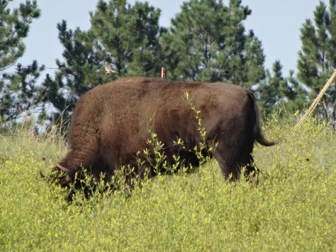
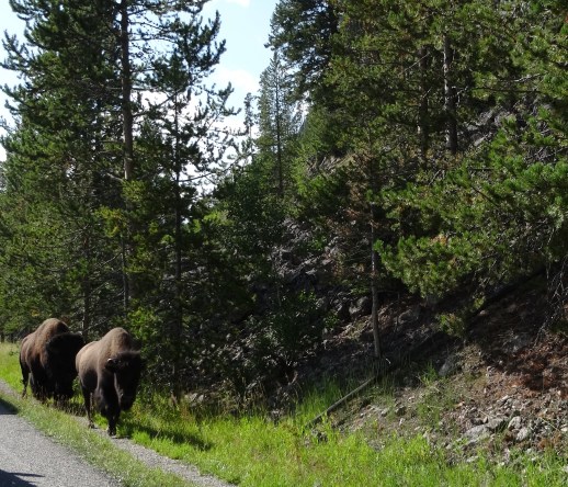
Upon entering Yellowstone National Park’s northeast entrance (located on the Montana-Wyoming border) we were greeted by Buffalo, and more buffalo escorted us throughout the 85 mile drive to the Grant Village Campground.


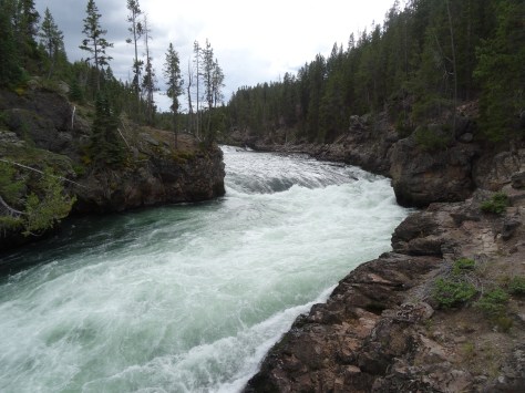
First stop along the trek was an overlook view of Tower Fall, the famous 132 foot waterfall of the Yellowstone River.

The overlook sits at the junction of the Yellowstone River and Tower Creek which also permitted us to experience the strength of the water forcing its way through the canyon.
There is no shortage of wonders along Grand Loop Road which wends through the heart of Yellowstone and around the north shore of Yellowstone Lake. For this reason, the two-and-a-half hour drive took us about four hours, getting us to our campground with just enough daylight to set up camp and grab dinner at Lake View Cafe.

Grant Village Campground
Grant Village is located in the southern end of the park on the “west thumb” of Yellowstone Lake, and within the volcano’s caldera. Our third experience camping, and our third experience pitching our tent in the rain.
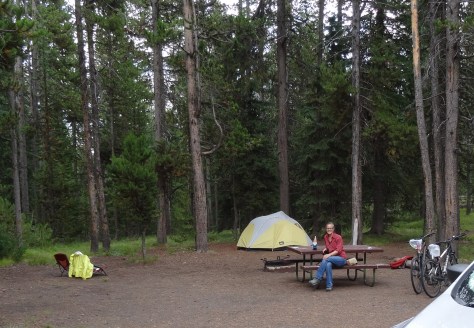
What a great camping experience! Our site, 391 on Loop K, was spacious and sits near the ledge of a shallow ravine.
Yellowstone is wild, and camping provides a great opportunity to experience that wild. On several nights we were awakened to the howls and barks of wolves running through the ravine below.
The third morning we woke with the sun and to a strange snorting noise outside our tent. A quick look out the window eased our minds – the noises were from two elk cows and four calves grazing just outside.


The calves decided to nestle down in the grass around our tent and keep us company through breakfast.
With everything one would need from restaurants, showers, a post office, and general store, Grant Village is truly a village. We particularly enjoyed exploring the campground by bicycle and the Ranger’s educational presentations at the visitors’ center.
We learned:
- Yellowstone’s supervolcano incurred three major eruptions over the past 2.1 million years, and it’s doubtful another one will take place within the next 10,000 years.
- Grizzlies’ forage after dark in the summer months and during the day in the spring and fall.
- The native lodgepole pine tree has a second type of cone that opens only under the extreme heat of fire assuring the species’ survival
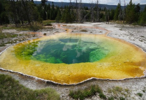
Thermal Geysers


There are more than 10,000 thermal geysers in Yellowstone, and Trey attempted to see them all! Kidding, but at times it seemed as if that was his goal.
Of course Old Faithful was a must-see, and due to its southern location, it was our first stop.

Most of the geyser touring areas line Highway 191 on the park’s west side. Raised boardwalks varying in distances from a quarter mile to two miles cut between geysers and keep visitors safe from the unstable, scalding hot ground.

While visiting each geyser area was impossible over a five-day period, we exhausted ourselves checking out Old Faithful Basin, Biscuit Basin, Fire Hole Loop, and Norris Geyser Basin.


Grand Teton National Park
Grand Teton’s north entrance is located 54 miles south of Yellowstone’s Grant Village which made it ideal for a day trip. After checking out Lewis Falls, we headed out of Yellowstone via the John D. Rockefeller, Jr. Memorial Parkway.


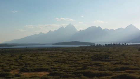
The Parkway follows the Snake River and then Jackson Lake, with the Tetons laid out along the other (west) side of the lake.


The day was spent mostly touring the park in the “Escape Mobile.” There is much to see by car including Signal Mountain, which offers great vantage points for both the Tetons and the Snake River Valley to the east.

The initial plan was to hike around Lake Jenny, but we decided to explore more of the park rather than spend the day on a 7-mile hike.
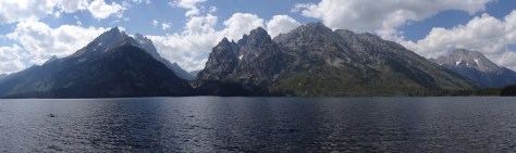
As an alternative, we chose the shorter Taggart Lake-Beaver Creek Trail, a 3.8 mile loop. Instead of looping, we hiked about a mile-and-a-half in and backtracked. The trail offered gorgeous shots of the Tetons.


A lovely day that we ended with a fabulous dinner at the Jackson Lake Lodge, donated to the park by JD Rockefeller, Jr. Despite being under-dressed in our hiking clothes, we were seated at window table with a prime view of the Tetons.


Great food! Afterwards, we stepped outside and onto the Lunch Tree Hill trail for a short hike up a ridge overlooking the valley and Grand Tetons. Trey was hoping to see moose, but the sun set while we waited.

Leaving Yellowstone
Having depleted most of our energy, we opted to pull up stakes in Yellowstone a day early, breaking up the 500+ drive to Spokane. We toured another geyser basin on our way to the west exit, where we were escorted out by more buffalo.
Note, though visiting Yellowstone in mid-August, we kept our jackets handy at all times. The evening temperatures fell into the 30’s, and some afternoons brought sudden, but short-lived, storms and hail.
More Yellowstone Wildlife…