After four days of non-stop escapades in San Francisco, Carmel-by-the-Sea was the perfect travel oasis!
Carmel Bay – Carmel-by-the-Sea, California
Carmel, which it is commonly referred as, was ideal for rejuvenating while basking aside the Pacific…
resting through peaceful strolls (and daily naps)…
and reconnecting to ourselves and the Universe through the surrounding beauty and serenity.
After a murky, foggy, twisty drive down Hwy 101, we arrived in Carmel exhausted and a bit stressed. Upon stepping out of the Escape Mobile, we immediately felt the city’s calming energy relax over us and welcome us with this view…
After stepping out of the Escape Mobile to this view, we knew Carmel was exactly where we should be at that moment
Once settled into our hotel, we walked to the nearest restaurant, Casanova for an amazing Italian dinner complete with romantic ambiance…
Daytime shot of Casanova Italian Restaurant
another welcoming gift from the Universe…
Exhausted but happy at Casanova’s, Carmel-by-the-Sea
Morning arrived with temperate ocean breezes and a gorgeous cloudless sky.
So of course, we walked straight to the beach where watched a pod of dolphin fishing along the shore…
and a scattering of humans out for their morning walks.
Carmel-by-the-Sea is small and picturesque, a perfect town to explore by foot and bicycle so the Escape Mobile remained parked for the duration of our stay.
We bicycled to the southern edge of town to the Basilica of San Carlos Borromeo de Carmelo Mission, the second of California’s 21 missions.
Basilica of San Carlos Borromeo de Carmelo Mission
The Carmel Mission was dedicated as a basilica in 1797, and is the fourth and last basilica we visited on our six-month U.S. tour. It was also the most humble – the one we sensed as the most authentic and sacred.
The grounds and structures are modest and peaceful and while we arrived too late for a tour, Trey and I enjoyed the special gift of watching the setting sun’s light play off the basilica’s chapel and gardens.
Near Carmel Mission, there’s access to parks, beaches, and several hiking trails including some that climb up and along the rocky shoreline. Since we were on bicycles, we opted to enjoy the views and laugh at grazing sheep instead.
Everything about this area is charming!
We loved exploring Carmel’s art galleries, streets, and its unique mix of architecture and styles, from streamlined cliff-side mansions to adorable tiny cottages.
Even our hotel was cute…
Best Western Town House Lodge, Carmel-by-the-Sea
Our second morning relaxing at the beach was cut short after cutting my foot on a piece of driftwood buried in the sand.
It wasn’t a terrible cut, but bad enough to avoid exposing it to sand and ocean bacteria. Following a generous slab of antibiotic ointment, a wrap, and elevating it for an hour, my foot was well enough for the next venture… the wine circuit.
Nearby Carmel Valley is home to thriving vineyards. Conveniently, many wineries also have tasting rooms in Carmel-by-the-Sea. We spent the afternoon sampling wines and bought five bottles: a red blend and Barbera from Silverstri; a Pinot Gris and Pino Nior from Manzoni; and a rosé from Dawn’s Dream.
Carmel Valley wines are excellent! We are not aficionados, but it’s our opinion that they can hold their own against California’s top rated regions.
Carmel Food
In addition to Casanova’s mentioned above, we enjoyed several other great food experiences. For dinner, Flaherty’s Seafood Grill was recommended by some fellow travelers from Australia and did not disappoint. Jack London’s Pub has since closed, but its onion rings were some of the best we’ve eaten.
And Em Le’s for breakfast was as quaint as is was good, but sadly it has also since closed.
Out of necessity, out last morning in Carmel was spent doing laundry and packing & shipping wine home to Austin.
Gassing up the Escape Mobile for the drive to Yosemite
A fire along CA Hwy 140 required us to change our route and add a 70-mile detour through Fresno in order to access or next destination…
Reservoir on the drive to Fresno – Evidence of California’s 2014 drought
Like in Chicago and Portland, staying in or near San Francisco’s city center was cost prohibitive, so we again used points and stayed at an airport hotel. The commute into San Francisco was about 25 minutes but ran aside the beautiful San Francisco Bay. Finding parking was never a problem as there are plenty of public, but pricey, garages.
Alcatraz – Messages of Freedom and Justice
Alcatraz is part of the National Park Service’s Golden Gate National Recreation Area. A ferry operated by a private company from Pier 33 is the only means to access the island. They run about every 30 minutes and you have to purchase fares for a specific departure time, but you can return whenever you’re ready.
That was a good thing as Trey and I became captivated by the island… its history and stories, and all the once hardened but now deteriorating skeletal structures juxtaposed amid beauty. (One only needs to look.)
We spent most of the day touring the former military outpost-then military prison-then federal penitentiary-now national treasure.
During our visit, Alcatraz was also serving as an art exhibit space. We were fortunate that our trip coincided with Chinese dissident artist Ai Weiwei’s exhibit @Large: Ai Weiwei on Alcatraz.
The installation exhibit filled two work rooms, and began with the wonderful, welcoming face of a giant, intricate paper dragon, its body comprising the full length of the room.
The contrast of vibrant colors against decaying prison walls was surreal. As were the Lego portraits and brave words of individuals imprisoned for voicing or acting upon their truths…
including Mr. Weiwei himself who at the time was being detained by the Chinese government.
The entire island is open for exploring and we spent as much time outside as we did inside the various cell blocks, industry/labor buildings, and administrative offices.
The NPS has done a great job (as always!) in telling and preserving Alcatraz’s stories, from its notorious prisoners and attempted breakouts to those of the families and children of guards that were also Alcatraz residents.
Recreation of cell used in notorious breakout and subject of the movie Escape From Alcatraz
We learned about the Native American 19-month (Nov 1969 – Jun 1971) occupation of the island. The cross-tribe participants (including the late Cherokee Chief Wilma Mankiller) claimed the island as their own citing an 1860’s treaty.
In reality, the takeover was an act of rebellion for past and ongoing injustices carried out by the U.S. Government against its native people. The civil disobedience effort was successful at calling attention to those injustices and their continued effects. We were happy to find that signs of the occupation are well preserved and protected as part of Alcatraz’s rich history.
San Francisco by Boat, Car, Bike, & Foot
BOAT Just before leaving Austin for this trek around the U.S., Trey and I struck up a conversation with a businessman at the downtown PF Chang’s bar. He was from San Francisco, so we quizzed him on what his #1 must-do-in-San Francisco recommendation was. “That’s simple!” he said. “You have to see San Francisco from the vantage point of its bay – sail out into the bay and under the Golden Gate Bridge.”
That’s exactly what we did on the “Privateer” through the San Francisco Sailing Company. The day was gorgeous, perfect for sailing! Plus, the unique views and perspectives we experienced were well worth the $60 ticket price.
We struck up a conversation with a couple sitting adjacent to us on the cozy sailboat and soon after regretted doing so. They were weirdly interested in us and toward the end of the trip, a bit too touchy and invading our personal spaces. We politely declined their invitation to join them at their home thinking that the boat’s sails were not the only thing they wanted to experience swinging that day. California!
The bay was beautiful though, and like our no-strings-attached friend at PF Chang’s, we highly recommend sailing around it to fully enjoy the San Francisco skyline and surrounding bridges and hills.
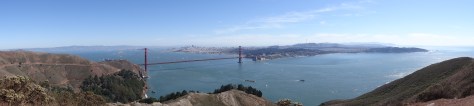
CAR Beginning in the late 1800’s and through World War II, the entrance to San Francisco Bay from the Pacific Ocean was deemed militarily vulnerable.
As such, a series of defense “batteries” were constructed along both the northern and southern shores. The remnants of these fortifications remain for intrigued tourists to explore. We selected the northern shore route because it allowed us to drive across the Golden Gate Bridge, a new experience for Trey.
Once across the bridge, we followed Conzelman Road that curved around the hills’ edges and offered amazing views of the bay, bridge, and city.
Stopping at Kirby Battery gave us a feel for what guarding America’s western gateway was like during World War II.
It’s easy to imagine diligent soldiers scouring the ocean’s horizon for enemy vessels and the skies for foreign aircraft while bunkered behind sixteen-inch barrel guns. The never used guns are long-gone, but the bunkers and other structures are open to climb about, picnic on, or find a peaceful moment while taking in the serene beauty.
Trey posing in a Kirby Battery tunnel
Continuing on Conzelman Road until it dead ended, we turned left onto Field Road which leads to the steep ledge of Bonita Point. The tiny Bonita Point Lighthouse sits atop a rugged crag and is accessible via a wooden suspension bridge – a good challenge for those wanting to confront a fear of heights.
The ocean and bay views are spectacular, but we enjoyed the scenes below the most… sunbathing seals and ocean spray rising from waves crashing upon black rocky ledges.
Heading inland on Field Road, we made our final stop back in time at Nike Missile Site SF-88…
Greely & Norton greeted us upon our arrival and kept careful watch over things
where we walked above ground among retired missiles and below ground where missiles were stored and readied for launch.
The site closed in the 1970’s and is well maintained by the NPS. Just as the old battery sites had done, this retired missile site provided a good sense of life at a cold war defense site.
BIKE From The Embarcadero’s Pier 39, it is about a 5.5 mile ride (one-way) across the Golden Gate. The route takes you along the beach, by gorgeous waterfront homes, and through Presidio to the Battery East Trail.
The climb up to the bridge is steep, but there are plenty of overlooks to stop, rest, and take in the changing scenery… another great way to enjoy the cityscape.
As we climbed we noticed a thick fog rolling in at a fury’s pace. It quickly engulfed the bridge and we wondered whether we’d be able to ride across the bridge, and if so… would we be able to see anything? By the time we huffed our way to bridge level and emerged from the trees there was no trace of fog, not a single remnant.
I understand that is how fog is in the bay area… it is an entity in itself, choosing to come and go, disrupt and displease at will.
The ride across the Golden Gate was thrilling. The rails are high enough and the path wide enough that we felt perfectly safe and comfortable crossing over and back on the 1.7 mile bridge.
Along with sailing around the bay, I consider bicycling across the Golden Gate as a San Francisco must-do!
FOOT We fell in love with San Francisco. It’s a very walkable city if you don’t mind hills. If you’d prefer to avoid hills then stick to the shoreline areas of Fisherman’s Wharf and the Embarcadero.
With loads of fabulous restaurants, shopping, boats, nightlife and wildlife, they contain essential elements of the quintessential San Francisco experience.
We also loved walking through Pacific Heights, China Town, and Telegraph Hill.
Lombard Street, San FranciscoTelegraph Hill, Coit Tower
Golden Gate Park was on our itinerary, but the streets surrounding it were impassable due to an annual bluegrass festival. Next time!
San Francisco Food
Breakfast – To offset the expense of eating out, we started most days with a cheap but hearty breakfast from Ed’s Diner in South San Francisco.
They served an excellent version of Trey’s favorite, the traditional American breakfast. We would fill ourselves enough to skip lunch and then carry a snack bar and piece of fruit to make it to dinner.
Our one breakfast exception was Mama’s On Washington Square, a recommendation by my sister-in-law who grew up in San Francisco.
We were warned that it is small and there is always a crowd, so we arrived twenty minutes before its 8:00 a.m. opening time. That wasn’t early enough to keep us from waiting in line, but the owner-operated café knows their business and has perfected a system of getting people in the door, through an ordering line, seated, served, and back out the door with a full stomach and happy heart.
The freshness and quality of the food is tops! The menu is extensive so I felt a bit overwhelmed with being pressured to order quickly and not hold up the line. We also completely forgot to record or photograph what we ordered.
Dinner – This is it! My absolute favorite dish from our trip around the United States…
Crab Enchiladas, Crab House – Pier 39
Crab Enchiladas from the Crab House at Pier 39. They were what I imagine eating in Heaven will be like. A melt in your mouth unique flavor, yet still enchilada tasting enough to be called an enchilada. The above photo is not an exaggeration, together the two enchiladas were the size of a Texas big-as-your-face burrito and I finished off each one then wiped the skillet clean.
Even Trey, who is not a shell food person, enjoyed the small bite I shared. He opted for the Fish & Chips, a very generous portion of perfectly fried and fluffy cod, served just as it should be.
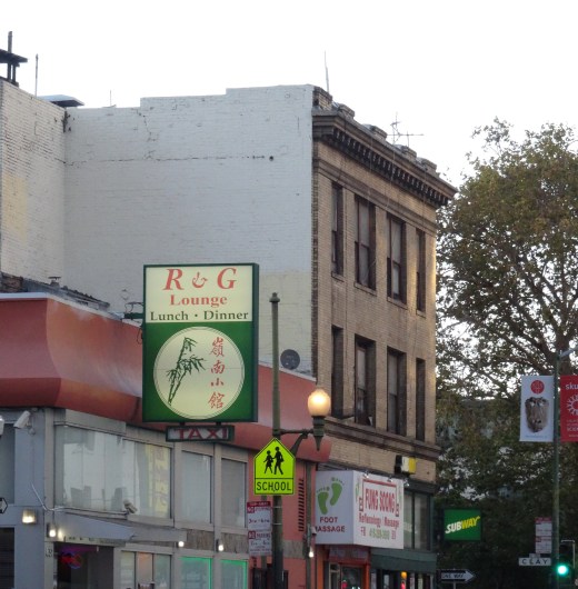
R & G Lounge in Chinatown – Authentic, traditional Chinese. We Texans felt a little out of place and lost at first, but the servers were kind and helpful, and the food was excellent.
McCormick & Kuleto’s Seafood & Steaks, Ghirardelli Square – we failed to take a photo of our meals and neither of us recall the meal. We do, however, vividly remember the gorgeous bay views.
We watched swimmers doing their evening laps while the sun set behind the hills and turned sailboats into silhouettes.
Dessert was a Caramel Sea Salt Hot Fudge Sundae that we split from Ghirardelli Chocolate Factory.
Errands and fatigue had us leaving Portland around 5pm. With a 4 ½ hour drive to Coos Bay ahead, we should have reconsidered our plan to cut back to U.S. Highway 101 at Newport.
Nope, we raced to the coast, arrived at the Pacific Ocean and turned left onto Highway 101 after sunset on a moonless night.
Gorgeous beaches and landscapes rolled out just beyond the Escape Mobile’s passenger-side windows, but we couldn’t see a damn thing. With concentration, we squinted to focus on the reflection markers aligning curves and helping to prevent cars from plummeting over cliffs. It was harrowing drive, but I imagine not as much as it was for the poor guy we passed riding a bicycle without a headlight. We would have offered him a ride but he was traveling the opposite direction. I still feel for him.
CB McCullough Memorial Bridge, Coos Bay
With a solid night’s sleep in a cozy Best Western, we awoke the next morning to discover Coos Bay a charming, hard-working, coastal community.
Timber was an obvious major industry for Coos Bay
Yelp led us to Mom’s Kitchen for a hearty breakfast with hashbrowns O’Brien, a Pacific Northwest staple we discovered in Seattle.
Mom’s Kitchen (photo borrowed from Yelp because we were too hungry to remember to take photos)
Next stretch…
Although cloudy, the Pacific views were gorgeous and non-stop!
Like the drive between Astoria and Lincoln City, we stretched the three hour trip into four hours with several stops to whale watch…
Spotted a pod of grey whales from the road in this inlet
Grey Whale
walk the beach…
and take photographs.
Approaching the California state line, we noticed a turnoff for “Arch Rock” viewing area. From the small parking area, a path leads through a mushroom lined thicket of firs to a ledge overlooking the Pacific.
Except for a friendly snake, we had the path and views to ourselves.
Overlook at Arch RockArch Rock, Oregon
From there, we were forty minutes away from our next destination… camping among the giant redwoods!
For US Hwy 101 Coastline Drive, Part 1, see Olympic National Park
For US Hwy 101 Coastline Drive, Part 2, see Astoria
Quaint Astoria sits on a peninsula barely east of where the Columbia River clashes with the Pacific Ocean. Outlined by Young’s Bay and River on its southern shoreline, with the mighty Columbia River comprising its north border.
Above Astoria, looking west: Views of the Pacific and Columbia, Young, and Lewis & Clark Rivers.
Yes, water is the heart, soul, and breath of the community. Its sustenance, and existence.
Accessing Astoria from Washington State requires either a boat or crossing the massive Astoria-Megler Bridge, a cantilever through-truss design. As we drove the 4.1 miles across to Oregon, my thoughts turned to my sister. Many times, she had relayed her dizzying experience bicycling over the Columbia River while water rushed in one direction below and crisscrossing cars whizzed past her side. I was grateful to be inside the Escape Mobile.
Astoria’s Welcome Party
Checking into our riverfront hotel just before sunset, we were greeted with an unrecognizable noise permeating throughout the lobby. Curiosity led us down a corridor and out a back door where the now recognizable barks overwhelmed our senses. Seals, hundreds of them, had taken over docks and landings sitting 150-ish yards away. Gladly, the barking did not disrupt our sleep.
With one full day to explore Astoria, we made the most of our time. First order was a must-visit to the Goondocks…
The Goonies House
a row of Victorian houses made famous in the 1985 Goonies movie. While we easily found parking and walked up to the primary “Goonies’ House” to snap photos, increased tourist traffic and mishaps have since halted such practices.
Next, a walk around and up into the Astoria Column provided both a historical accounting and scenic overview of the area.
Styled after Rome’s Trajan Column (which Trey has since visited), its spiraling pictorials tell of the “discovery” of the Columbia River, Lewis and Clark’s expedition, and the arrival of John Jacob Astor’s merchant ship which was instrumental in establishing Astoria as a key outpost in North America’s fur trade, helping Astor to control much of that trade. How ironic, or perhaps “offensive’ is more fitting, that Astor’s descendants later dedicated the column as a memorial to the Chinook Indians.
The remainder of Astoria was explorable by bicycle via The Riverwalk…
Trey on The Riverwalk near base of Astoria-Megler Bridge
a roughly 5-mile pathway following the Columbia River bank from the peninsula’s westernmost point, and turning into forested hills at the eastern end.
Eastern end of Astoria’s Riverwalk bike path
Along the way, The Riverwalk provides easy access to downtown shops and restaurants. Note, a trolley line follows much of the pathway.
During our bike ride, we enjoyed eating wild blackberries growing aside the pathway, watching the day’s catch being unloaded, the ever-present wildlife, and being entertained by Coast Guard drills while eating pizza.
Astoria is charming with a laid-back, fun vibe that balances well with the hard work and challenges that I imagine accompany living at the convergence of three rivers and an ocean. Also apparent was Astoria’s reliance on tourism.
Astoria Food experiences…
A bit of a foodie city, there were several on-budget options. Five stars to T Paul’s Supper Club for dinner, Street 14 Café for coffee and lunch, and the chain restaurant Pig N’ Pancake was a breakfast favorite for locals and tourists.
Fort Clatsop – Lewis and Clark National Historical Park
Fort Clatsop is just south of Astoria so we saved this historical site for the morning of our departure. The fort sits where the Lewis and Clark expedition settled in for winter, awaiting and planning for their return east.
All structures are replicas based on surviving journal entries. A footpath leads to the Lewis and Clark River and follows the shore 1-1/2 miles to Netul Landing (Netul is the river’s original name).
View of Lewis & Clark River from footpath to Netul Landing
US Hwy 101 Coastline Drive – Part Two
Mesmerized with our first Oregon coast drive, we stretched the 2 hour and forty minute trip to Lincoln City into most of the day; stopping at numerous overlooks…
touring Tillamook Cheese Factory…
Tillamook’s exceptionally clean packaging area
and traipsing between homes to access a public beach…
Lovely day best expressed through photographs:
We arrived in Lincoln City at sunset, without hotel reservations, and famished. Trey had spotted Puerto Vallarta Mexican Restaurant as we entered town — best Tex-Mex fix since Pittsburgh, margaritas included of course.
Trey checking in
Lincoln City’s Sailor Jack Inn stands out as one of our more memorable sleeping experiences; notable in a unique, funny, and lets-not-do-that-again way. It was a cheap motel with a million dollar view.
Slinking carefully into bed, we drifted to sleep easily to the sound of crashing waves. I’m sure the margaritas were helpful, too!
Woke the next morning to clear skies, and another Pig N’ Pancake breakfast fueled our bodies for the drive inland to Portland.
The last morning of our Alaskan cruise, breakfast table-mates recommended hiking Hurricane Ridge, along the northern border of Olympic National Park. With our late departure from Seattle, we decided to spend the night in Port Angeles, a 160 mile drive from Bainbridge Island, and hike the nearby ridge the following morning.
Located on the U.S. side of the Strait of Juan de Fuca and with a ferry crossing to Victoria, Port Angeles was a bit of a tourist destination.
View of Port Angeles with Victoria BC in the distance
We hadn’t accounted for that, nor the fact that it was Saturday. Pulling into town, scores of hotels greeted us… all full or over budget. Before continuing westward, we looped back into town and noticed the Riviera Inn. The unassuming, yet comfortable and clean motel had a few vacancies available.
Also surprised by the many culinary options, we decided on Italian for dinner at Bella Italia and breakfast at First Street Haven, both on East 1st Street (Hwy 101 East). And both good and on budget.
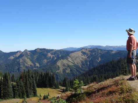
Olympic National Park North – Hurricane Ridge
Encompassing more than 1,400 square miles and the Olympic Mountain Range, with Mount Olympus near its center, one doesn’t drive through Olympic National Park. Like Mount Rainier, you steer around it and enter through various access roads along its changing ecological perimeter.
Relative to the rest of the park, the north is dry with a mix of meadows and foothills leading into the steeper heart of the park.
After a stop at the Hurricane Ridge Visitor Center, we were able to continue onto, and park at, the trailhead.
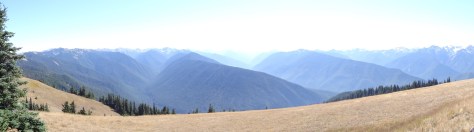
Rising 700 feet over 1.6 miles, the hike up Hurricane Hill is easy to moderate, and the stunning panoramas are absolutely worth it!
Lots of wildlife, too!
Hurricane Ridge Marmot
The amazing 360 views beckoned us to stay longer, so we settled down under the shade of a tree to fully absorb the beauty.
Hurricane Ridge Butterflies
It wasn’t long before we were surrounded by treat-seeking chipmunks and bunnies.
Lake Crescent & Marymere Falls
About thirty miles west of Port Angeles, we came across Crescent Lake and a sign post for Marymere Falls. The trail to the falls was just shy of a mile, wound through giant firs and hemlock trees, and deer grazed just off the trail.
Marymere Falls
That excursion, the extra time spent atop Hurricane Hill, and a stop for hamburgers in Forks, positioned us in a race with the setting sun to the pacific coast.
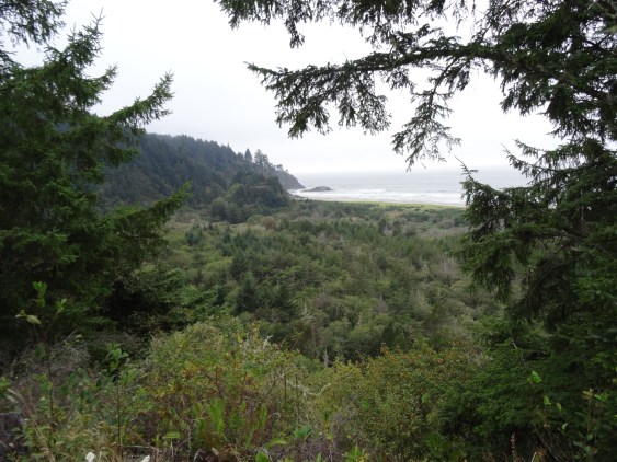
Arriving at Ruby Beach with just enough light to capture a few photos, we were happy to have officially arrived at the Pacific Ocean. A gorgeous welcome and a memorable setting for what I consider our third left turn around the U.S.
Olympic National Park South – Quinault Rainforest
Most National Parks we visited had park-owned lodges that are historic in some context related to the parks’ origin. And all of these lodges are well over our price point, as was the case for Lake Quinault Lodge.
Lake Quinault Lodge
Due to its remoteness along with our eagerness to experience a national park lodge, we made a one-night exception.
Arriving after 9pm, and tired from the day’s hikes, we were thrilled with the prospect of a warm comfortable bed over pitching the tent and blowing up air mattresses.
The next day, we’d arranged an early morning educational tour with a park ranger, so we grabbed breakfast to go and jumped into a van.
Olympic National Park Ranger
Over four hours, we learned about river restoration efforts and the rainforest’s trees and plants. We discovered how the Olympic Mountains were formed by glaciers, and visited the “world’s largest spruce tree…”
several waterfalls…
and this guy:
MOSSQUATCH
Before departing Lake Quinault Lodge, we took the time to explore its tranquil grounds and enjoy a quick lunch.
The lodge is operated and well maintained by the Quinault Indian Nation, an indigenous sovereign nation. We regretted not being able to spend more time there.
Not included on the tour, the ranger told us of nearby “Big Cedar,” assuring it was worth the half-mile hike.
Quinnault Big Cedar
Located across the lake from the lodge, we decided to visit the ancient tree (1,500 years old) on our own. So glad we did, as it has since fallen due to a storm in July 2016.
US Hwy 101 Coastline Drive – Part One
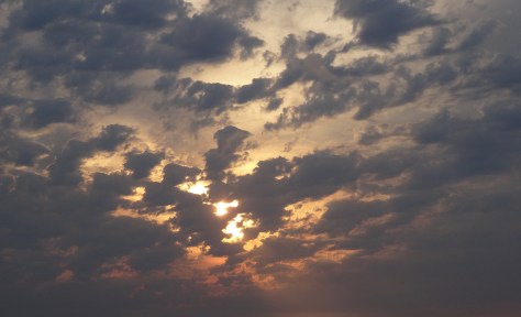
The sun had set by the time we left Ruby Beach and turned southward down the coastline, so we missed what I imagine are magnificent views of the Pacific. On the way to Astoria, we got a taste of what we had missed, and of what was to come…
Sun setting near Astoria, Oregon
More Pics…
Sully’s in Forks, Washington (We didn’t realize we were in the Twilight zone until we stopped to eat and saw this on the menu.)
Arriving at Ruby Beach
And because I love trees…
This is a record of Trey & Martha's 2014 U.S. travel adventures


")


")