I am a traveler, a writer, and a seeker of truth and beauty.
Author of THE UNINTENDED CONSEQUENCES OF NOT LIVING FULLY (Available on Amazon)
Based in Austin, Texas
Errands and fatigue had us leaving Portland around 5pm. With a 4 ½ hour drive to Coos Bay ahead, we should have reconsidered our plan to cut back to U.S. Highway 101 at Newport.
Nope, we raced to the coast, arrived at the Pacific Ocean and turned left onto Highway 101 after sunset on a moonless night.
Gorgeous beaches and landscapes rolled out just beyond the Escape Mobile’s passenger-side windows, but we couldn’t see a damn thing. With concentration, we squinted to focus on the reflection markers aligning curves and helping to prevent cars from plummeting over cliffs. It was harrowing drive, but I imagine not as much as it was for the poor guy we passed riding a bicycle without a headlight. We would have offered him a ride but he was traveling the opposite direction. I still feel for him.
CB McCullough Memorial Bridge, Coos Bay
With a solid night’s sleep in a cozy Best Western, we awoke the next morning to discover Coos Bay a charming, hard-working, coastal community.
Timber was an obvious major industry for Coos Bay
Yelp led us to Mom’s Kitchen for a hearty breakfast with hashbrowns O’Brien, a Pacific Northwest staple we discovered in Seattle.
Mom’s Kitchen (photo borrowed from Yelp because we were too hungry to remember to take photos)
Next stretch…
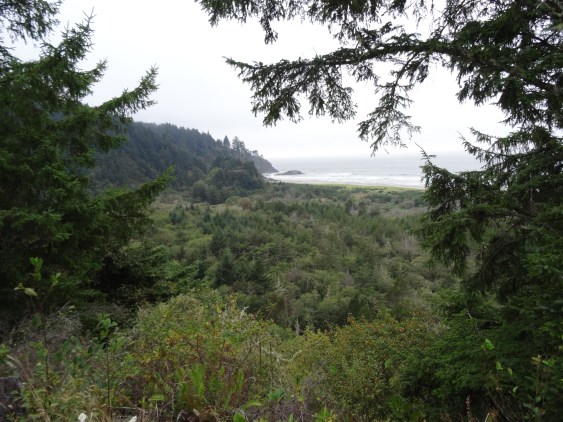
Although cloudy, the Pacific views were gorgeous and non-stop!
Like the drive between Astoria and Lincoln City, we stretched the three hour trip into four hours with several stops to whale watch…
Spotted a pod of grey whales from the road in this inlet
Grey Whale
walk the beach…
and take photographs.
Approaching the California state line, we noticed a turnoff for “Arch Rock” viewing area. From the small parking area, a path leads through a mushroom lined thicket of firs to a ledge overlooking the Pacific.
Except for a friendly snake, we had the path and views to ourselves.
Overlook at Arch RockArch Rock, Oregon
From there, we were forty minutes away from our next destination… camping among the giant redwoods!
For US Hwy 101 Coastline Drive, Part 1, see Olympic National Park
For US Hwy 101 Coastline Drive, Part 2, see Astoria
Having heard of Portland’s similarities to Austin (music scene, laid back feel, open-minded residents, etc.), we were ready to experience a taste of home.
Staying in downtown Portland wasn’t feasible, in either dollars or hotel points. Instead, we used points to stay near the Portland International Airport and used Portland’s MAX Light Rail system to get around. The Red Line stopped directly in front of our hotel; from there it was a straight shot into the heart of Portland, so the Escape Mobile remained parked for most of our stay!
Waterfront Biking
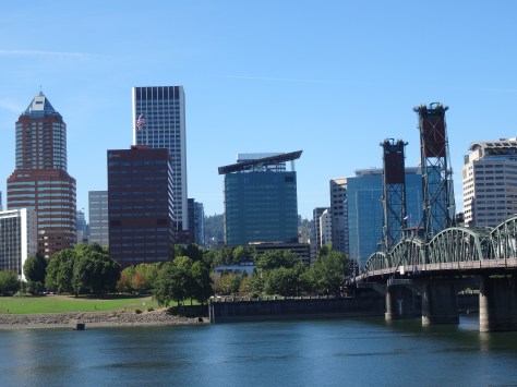
Portland’s most notable similarity to Austin is its river, the Willamette, which cuts through the city’s center.
City and Hawthorne Bridge View, Portland
Both banks of the Willamette River are aligned with businesses, hot spots, public parks, gathering spaces, and walking/jogging/biking paths.
Convention Center Towers
Carrying our bikes onto the Red Line, we stopped west of the river to begin a clockwise 11-mile waterfront ride. The Sellwood Bridge Loop led us alongside downtown and across the iconic Steel Bridge, a double-decker vertical-lift bridge completed in 1912.
Steele Bridge Portland
Biking along the Willamette was a great way to explore the city and spot wildlife.
Trey on the Sellwood Bridge Loop
Osprey on the Willamette River
Trey was thrilled at the site of a decommissioned naval submarine, the USS Blueback (SS-581)…
USS Blueback (SS-581)
and we both loved the row of float houses near Sellwood Bridge!
Columbia River Gorge
View of Columbia River Gorge from Vista House
The Columbia River Gorge begins about twenty miles east of Portland and is accessible via U.S. Highway 30, also known as the Historic Columbia River Highway. The first must stop is Vista House…
an overlook and information center completed in 1918 located on Crown Point, one of the gorge’s highest points. Vista House offers great panoramas of the gorge, river valley and surrounding hills.
We were surprised to see windsurfers whisking atop the Columbia River, but the area below Crown Point is a popular spot for the sport.
Waterfalls dropping from rocky cliffs dot the riverbank as you head east into the gorge. Most, including Latourell Falls and Shepperd’s Dell, are either visible from the highway or a short hike.
Latourell Falls, Columbia River Gorge
Fall Colors at Shepperd’s Dell Falls
Bridal Veil was our favorite. The trail crosses a creek that may deter some from completing the half-mile trek, but keep going. The two-tiered waterfall is definitely worth it!
Trey at Bridal Veil Falls
We climbed atop a huge boulder and basked in the sun while red and yellow leaves rained down upon us.
Multnomah Falls, photographers’ favorite, was packed and we had to nudge our way across Benson Bridge to access the trail to the top of the falls.
Multnomah Falls, Columbia River Gorge
The roundtrip 2.2 mile hike climbs 700 feet via eleven switchbacks. Although it’s labeled as moderate, wear hiking boots or tennis shoes and allow time for breath breaks if you’re not in good shape.
The 4.8 mile loop trail we’d planned to take from the top of Maltnomah Falls over to Wahkeena Falls was closed, so it was down the switchbacks to the car for a backtrack drive west.
Wahkeena Falls, Columbia River Gorge
Trey hopped over the concrete barrier, across mossy rocks, and balanced on the creek’s ledge to get the above shot.
Portland Night Life
While visiting downtown for dinner the evening of our arrival, we were surprised to find Portland streets subdued with only a few people out and about. We figured that was because it was a Thursday. The next evening, and after a long day of bicycling, we explored the Pearl District, an area described as “buzzing” with loads of unique dining options. While there were a few more folks walking around the Pearl District, there was neither buzz nor music. This was consistent throughout our stay.
Portland lacked Austin’s vibe, that definable energy evident upon deboarding at Austin-Bergstrom International Airport where one is met with local eats and live music.
Although the weather was gorgeous, maybe our visit coincided with Portland’s downtime, or we turned down the wrong street and missed music venues. I don’t know.
The most excitement we observed were the long, munchie lines outside of Voodoo Doughnuts. Maybe that’s why all the good people of Portland were so quiet and laidback?
Mountainous Horizon
On the Red Line from the airport, there’s a five-second window where Mt. Hood, Mt. Saint Helens and Mt. Rainier can all be viewed.
Mount Hood from MAX Light Rail Red Line
You need a clear day and good neck flexibility; we managed it once.
A local informed us of another vantage point in town where there’s time to appreciate the views and take photographs. In the late afternoon and on our way out of town, we stopped by Pittock Mansion, a restored chateau built in the early 1900’s by one of Portland’s legacy families.
We arrived too late to tour the home, but enjoyed strolling the magnificent grounds and the views of Portland.
Unfortunately, clouds and haze prevented us from seeing any mountains before it was time to hit the road again.
Destinations Known: Coos Bay for the night, then into the Redwood Forest!
More Pics…
Boat dock near Hawthorne Bridge
Latourell Falls through the trees
Tiny Waterfall along Columbia River Gorge
Trey on hike to Bridal Veil FallsElmer’s German Pancake, Yum!
Quaint Astoria sits on a peninsula barely east of where the Columbia River clashes with the Pacific Ocean. Outlined by Young’s Bay and River on its southern shoreline, with the mighty Columbia River comprising its north border.
Above Astoria, looking west: Views of the Pacific and Columbia, Young, and Lewis & Clark Rivers.
Yes, water is the heart, soul, and breath of the community. Its sustenance, and existence.
Accessing Astoria from Washington State requires either a boat or crossing the massive Astoria-Megler Bridge, a cantilever through-truss design. As we drove the 4.1 miles across to Oregon, my thoughts turned to my sister. Many times, she had relayed her dizzying experience bicycling over the Columbia River while water rushed in one direction below and crisscrossing cars whizzed past her side. I was grateful to be inside the Escape Mobile.
Astoria’s Welcome Party
Checking into our riverfront hotel just before sunset, we were greeted with an unrecognizable noise permeating throughout the lobby. Curiosity led us down a corridor and out a back door where the now recognizable barks overwhelmed our senses. Seals, hundreds of them, had taken over docks and landings sitting 150-ish yards away. Gladly, the barking did not disrupt our sleep.
With one full day to explore Astoria, we made the most of our time. First order was a must-visit to the Goondocks…
The Goonies House
a row of Victorian houses made famous in the 1985 Goonies movie. While we easily found parking and walked up to the primary “Goonies’ House” to snap photos, increased tourist traffic and mishaps have since halted such practices.
Next, a walk around and up into the Astoria Column provided both a historical accounting and scenic overview of the area.
Styled after Rome’s Trajan Column (which Trey has since visited), its spiraling pictorials tell of the “discovery” of the Columbia River, Lewis and Clark’s expedition, and the arrival of John Jacob Astor’s merchant ship which was instrumental in establishing Astoria as a key outpost in North America’s fur trade, helping Astor to control much of that trade. How ironic, or perhaps “offensive’ is more fitting, that Astor’s descendants later dedicated the column as a memorial to the Chinook Indians.
The remainder of Astoria was explorable by bicycle via The Riverwalk…
Trey on The Riverwalk near base of Astoria-Megler Bridge
a roughly 5-mile pathway following the Columbia River bank from the peninsula’s westernmost point, and turning into forested hills at the eastern end.
Eastern end of Astoria’s Riverwalk bike path
Along the way, The Riverwalk provides easy access to downtown shops and restaurants. Note, a trolley line follows much of the pathway.
During our bike ride, we enjoyed eating wild blackberries growing aside the pathway, watching the day’s catch being unloaded, the ever-present wildlife, and being entertained by Coast Guard drills while eating pizza.
Astoria is charming with a laid-back, fun vibe that balances well with the hard work and challenges that I imagine accompany living at the convergence of three rivers and an ocean. Also apparent was Astoria’s reliance on tourism.
Astoria Food experiences…
A bit of a foodie city, there were several on-budget options. Five stars to T Paul’s Supper Club for dinner, Street 14 Café for coffee and lunch, and the chain restaurant Pig N’ Pancake was a breakfast favorite for locals and tourists.
Fort Clatsop – Lewis and Clark National Historical Park
Fort Clatsop is just south of Astoria so we saved this historical site for the morning of our departure. The fort sits where the Lewis and Clark expedition settled in for winter, awaiting and planning for their return east.
All structures are replicas based on surviving journal entries. A footpath leads to the Lewis and Clark River and follows the shore 1-1/2 miles to Netul Landing (Netul is the river’s original name).
View of Lewis & Clark River from footpath to Netul Landing
US Hwy 101 Coastline Drive – Part Two
Mesmerized with our first Oregon coast drive, we stretched the 2 hour and forty minute trip to Lincoln City into most of the day; stopping at numerous overlooks…
touring Tillamook Cheese Factory…
Tillamook’s exceptionally clean packaging area
and traipsing between homes to access a public beach…
Lovely day best expressed through photographs:
We arrived in Lincoln City at sunset, without hotel reservations, and famished. Trey had spotted Puerto Vallarta Mexican Restaurant as we entered town — best Tex-Mex fix since Pittsburgh, margaritas included of course.
Trey checking in
Lincoln City’s Sailor Jack Inn stands out as one of our more memorable sleeping experiences; notable in a unique, funny, and lets-not-do-that-again way. It was a cheap motel with a million dollar view.
Slinking carefully into bed, we drifted to sleep easily to the sound of crashing waves. I’m sure the margaritas were helpful, too!
Woke the next morning to clear skies, and another Pig N’ Pancake breakfast fueled our bodies for the drive inland to Portland.
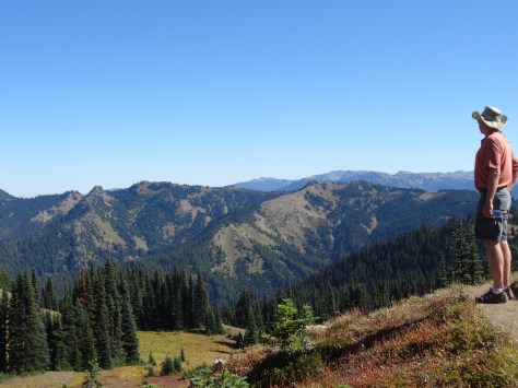
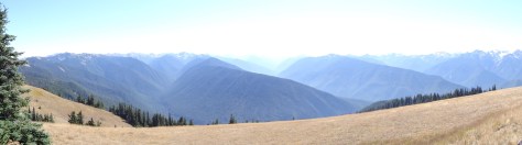
The last morning of our Alaskan cruise, breakfast table-mates recommended hiking Hurricane Ridge, along the northern border of Olympic National Park. With our late departure from Seattle, we decided to spend the night in Port Angeles, a 160 mile drive from Bainbridge Island, and hike the nearby ridge the following morning.
Located on the U.S. side of the Strait of Juan de Fuca and with a ferry crossing to Victoria, Port Angeles was a bit of a tourist destination.
View of Port Angeles with Victoria BC in the distance
We hadn’t accounted for that, nor the fact that it was Saturday. Pulling into town, scores of hotels greeted us… all full or over budget. Before continuing westward, we looped back into town and noticed the Riviera Inn. The unassuming, yet comfortable and clean motel had a few vacancies available.
Also surprised by the many culinary options, we decided on Italian for dinner at Bella Italia and breakfast at First Street Haven, both on East 1st Street (Hwy 101 East). And both good and on budget.
Olympic National Park North – Hurricane Ridge
Encompassing more than 1,400 square miles and the Olympic Mountain Range, with Mount Olympus near its center, one doesn’t drive through Olympic National Park. Like Mount Rainier, you steer around it and enter through various access roads along its changing ecological perimeter.
Relative to the rest of the park, the north is dry with a mix of meadows and foothills leading into the steeper heart of the park.
After a stop at the Hurricane Ridge Visitor Center, we were able to continue onto, and park at, the trailhead.
Rising 700 feet over 1.6 miles, the hike up Hurricane Hill is easy to moderate, and the stunning panoramas are absolutely worth it!
Lots of wildlife, too!
Hurricane Ridge Marmot
The amazing 360 views beckoned us to stay longer, so we settled down under the shade of a tree to fully absorb the beauty.
Hurricane Ridge Butterflies
It wasn’t long before we were surrounded by treat-seeking chipmunks and bunnies.
Lake Crescent & Marymere Falls
About thirty miles west of Port Angeles, we came across Crescent Lake and a sign post for Marymere Falls. The trail to the falls was just shy of a mile, wound through giant firs and hemlock trees, and deer grazed just off the trail.
Marymere Falls
That excursion, the extra time spent atop Hurricane Hill, and a stop for hamburgers in Forks, positioned us in a race with the setting sun to the pacific coast.
Arriving at Ruby Beach with just enough light to capture a few photos, we were happy to have officially arrived at the Pacific Ocean. A gorgeous welcome and a memorable setting for what I consider our third left turn around the U.S.
Olympic National Park South – Quinault Rainforest
Most National Parks we visited had park-owned lodges that are historic in some context related to the parks’ origin. And all of these lodges are well over our price point, as was the case for Lake Quinault Lodge.
Lake Quinault Lodge
Due to its remoteness along with our eagerness to experience a national park lodge, we made a one-night exception.
Arriving after 9pm, and tired from the day’s hikes, we were thrilled with the prospect of a warm comfortable bed over pitching the tent and blowing up air mattresses.
The next day, we’d arranged an early morning educational tour with a park ranger, so we grabbed breakfast to go and jumped into a van.
Olympic National Park Ranger
Over four hours, we learned about river restoration efforts and the rainforest’s trees and plants. We discovered how the Olympic Mountains were formed by glaciers, and visited the “world’s largest spruce tree…”
several waterfalls…
and this guy:
MOSSQUATCH
Before departing Lake Quinault Lodge, we took the time to explore its tranquil grounds and enjoy a quick lunch.
The lodge is operated and well maintained by the Quinault Indian Nation, an indigenous sovereign nation. We regretted not being able to spend more time there.
Not included on the tour, the ranger told us of nearby “Big Cedar,” assuring it was worth the half-mile hike.
Quinnault Big Cedar
Located across the lake from the lodge, we decided to visit the ancient tree (1,500 years old) on our own. So glad we did, as it has since fallen due to a storm in July 2016.
US Hwy 101 Coastline Drive – Part One
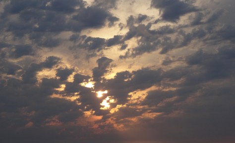
The sun had set by the time we left Ruby Beach and turned southward down the coastline, so we missed what I imagine are magnificent views of the Pacific. On the way to Astoria, we got a taste of what we had missed, and of what was to come…
Sun setting near Astoria, Oregon
More Pics…
Sully’s in Forks, Washington (We didn’t realize we were in the Twilight zone until we stopped to eat and saw this on the menu.)
Although Trey and I wanted to see Alaska, it was not on our original wish list of sites and landmarks to visit during our six-month journey. Neither recall why we had not considered Alaska, nor do we remember how we came to realize it was doable. Since we’d booked the cruise only a month prior, the inspiration probably came from one of the many bikers and fellow travelers we encountered during our stay in the Black Hills of South Dakota.
Our “we will figure it out” mentality is all about being open to options and opportunities. As I’ve written elsewhere, “It’s about having faith… that we will know which paths to take as we approach the many crossroads of our journey.”
ALASKAN CRUISE
First Sunset of our Alaskan Cruise
“ It’s the beauty that thrills me with wonder, It’s the stillness that fills me with peace.” The Spell of the Yukon, Robert W. Service
Truth is of the highest importance to me. In fact, my book’s subtitle is Truth is Sacred. So here’s a serving of truth about non-stop travel that may not be disclosed or properly portrayed in travel blogs, including this one:
It isn’t necessarily glamorous; it can be exhausting; it’s not conducive to practicing self-care; and immune systems get weary.
Since leaving Austin more than three months prior, I had already experienced two bouts of food poisoning. First, from sketchy pigs ‘n blankets in Atlantic City, and then from a salad in Ottawa. The latter round was especially ugly, but nowhere as odious as the 38 hours I endured in our cabin’s miniature bathroom…I’ll spare you further details, just be assured it was the opposite of glamorous.
Being a seven-day cruise, I was able to rebound and enjoy most of the amazing scenery…
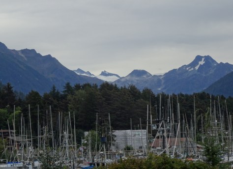
Juneau, Alaska
Alaska’s Capital, Juneau is a bustling tourist and government hub relative to the other communities we visited.
Alaska’s (unremarkable, yet practical) Capitol Building
The path from the cruise port to the capitol building is a gauntlet of high-end jewelry stores and low-end souvenir vendors.
Our floating hotel blends in with downtown Juneau buildings
Our shopping goals included lunch and one item, a corkscrew to evade the cruise line’s corkage fee. We found both at the Red Dog Saloon. (Note, upon initial embarking, most cruise lines allow each guests (21+) to carry on one bottle of unopened wine. Don’t forget the corkscrew!)
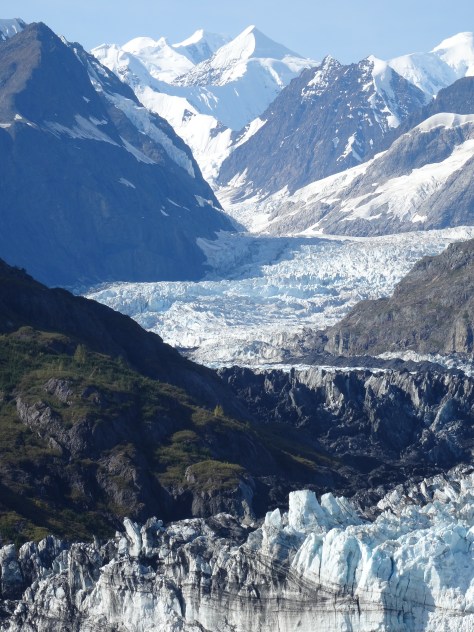
Glacier Bay National Park
Glacier Bay was the highlight of Trey’s Alaskan scenic experience. Due to the aforementioned illness, I was officially quarantined in the cabin for the duration of our time in Glacier Bay.
Though weak and fog-headed, I loved Trey’s regular and enthusiastic updates of the 65-mile voyage up Glacier Bay into Tarr Inlet. At some point, the ship was boarded by National Park Rangers to help with navigation into the bay’s narrow inlets and conduct informational discussions as we cruised past islands, wildlife, and glacial rivers.
Margerie Glacier
Travel into John Hopkins Inlet was not on the day’s itinerary, but the captain announced he’d been granted permission to enter the inlet due clear weather and decreased ice floes.
Ice floe, John Hopkins Inlet
Ice Cave, John Hopkins Inlet
Through the photos Trey captured and his excitement in describing the day, I experienced it with him. It was absolutely beautiful!
Grand Pacific Glacier
John Hopkins Glacier
Sitka, Alaska
Sitka’s city center sits on Baranov Island.
Sitka Sound
Our ship docked among the numerous tiny islands dotting Sitka Sound, and disembarking was done via a ship’s tender – a new transportation experience for us.
Tender unloading passengers
A hard working fishing community, Sitka was closer to our expectations of an Alaskan city than Juneau…
less touristy, with a focus on its people and history. For me, it was like I had finally arrived in true Alaska.
Originally the site of Tlingit Village, Sitka’s roots are prominently displayed throughout. Totems align a walking path in Sitka National Historic Park, and a Russian Orthodox Church is the focal point of Lincoln Street, the city’s main street.
With limited time, and even less energy on my part, we were not able to explore beautiful Sitka as we would have liked. Yet, we were there long enough to discern it as a unique community full of grit, charm, and justified pride.
Baranov Totem
Raven, Baranov Totem
Rockwell Lighthouse, Sitka
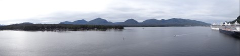
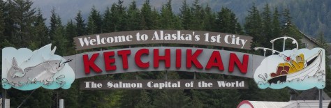
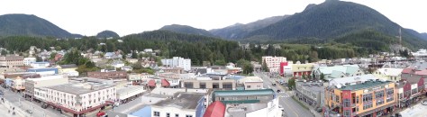
Ketchikan, Alaska
Ketchikan Harbor
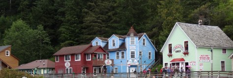
I immediately recognized Ketchikan from photographs my parents had taken decades before. Quaint, colorful, and picturesque. Creek Street, and its elevated walk lined with vibrant shops perched above Ketchikan Creek, is quintessential Alaska.
We followed other tourists across wooden planks, in and out of shops, and around bends of the creek where an unimaginable number of salmon were making their way upstream.
Continuing beyond the walkway’s end, we found a trail leading up to and through a thicket of firs…
eventually emerging where the creek flattened and opened into a larger pool. Spawning salmon provided the effects of churning currents and rapids within the pool – a truly wondrous display.
With much amusement, we watched a beaver disguise himself with a palm leaf as he snuck into the pool for lunch.
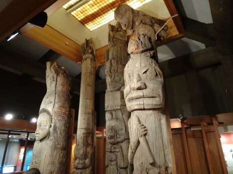
Rather than backtrack, we opted to forge our own path back to the cruise ship, and on the way, discovered totems, Ketchikan’s City Park…
and the Totem Heritage Center, a sanctuary of 19th century Red Cedar totems rescued from neighboring uninhabited Tlingit and Haidi village sites.
Chief Johnson’s original totem is in the foreground
The center was established in 1976 to prevent further erosion and destruction of the totems.
Fog Woman – Chief Johnson’s Totem (Replica)
Kajuk Bird – Chief Johnson’s Totem (Replica)
Butchart Gardens, Victoria, BC
After sailing five hours from Ketchikan, we docked in Victoria, British Columbia. We were happy to be back, and chose to spend our time on an evening excursion to Butchart Gardens.
Butchart Gardens Sunken Garden
Truly stunning, Butchart Gardens is a must see. The vision of a cement baron’s wife, its expansive gardens stretch across 55 acres in and around the site of a former quarry, the rock source for the cement that helped to construct Victoria and British Columbia.
Arriving at sunset, our visit was muted by the lack of daylight, but enhanced by fantastic light shows and special effects lighting that illuminated spectacular blooms.
Daytime or nighttime tour? I cannot say which is better, having not experienced the former. I think perhaps they’re just very different, and cannot be compared.
Though restricted on time, we managed to stroll through each section, starting with the sunken garden, through the rose garden, and finishing in the Italian garden.
Butchart Gardens – Japanese Garden
Butchart Gardens – Italian Garden
Sequoia Tree, planted from a seedling in 1934
It’s a good thing we didn’t linger much longer, as the shuttle bus driver had miscounted heads and was readying to head back to the cruise port.
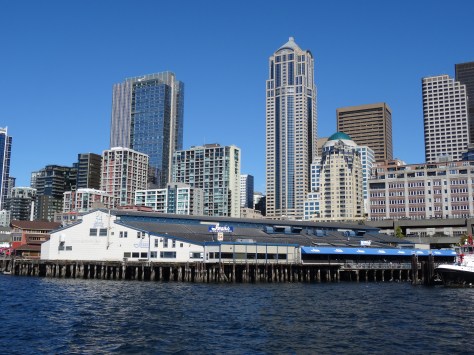
Disembarkment in Seattle began the next morning, a Saturday, at 7:00 a.m. Having endured long lines during initial boarding, we resolved to pay for an early disembarkment time.
Numerous tasks awaited, including dirty laundry, returning a borrowed formal dress (required for some cruise dinners), and retrieving our bicycles and camping gear from storage.
It was nearing 2pm when we purchased tickets for the next ferry crossing to Bainbridge Island, leaving just enough time to walk next door and grab some fish n’ chips at Ivan’s Acres of Clams. Then it was…
Seattle was our Pacific Northwest outpost, a temporary base to recalibrate, rest, replenish, and repair before making the official third left turn of our trek around the U.S.
Between arranging for storage of our gear, bike tune-ups and repairs, and servicing the Escape Mobile, we worked in some sightseeing, local bites, and what I looked forward to most…
Taken at a later gathering
reconnecting with dear friends. I actually consider the English’s as family, as they were quasi-parents during my tween years.
With a hectic schedule, we failed to capture photos of the hilly, eclectic, quaint, and prosperous Queen Anne neighborhood. This photo is borrowed from an online visitors’ guide.
Walking distance to grocery stores, restaurants, and a laundry mat, our Queen Anne neighborhood Airbnb townhome provided a quaint and comfortable refuge. Sitting on a hill overlooking Elliott Bay, Queen Anne is a historic neighborhood with a mix of Victorian cottages and mansions.
Sailboat on Elliott Bay
Its central location provides easy access to downtown, tourist destinations, and major thoroughfares. Note within the neighborhood and around Seattle, the roadways twist, ascend and wind around in every direction making it difficult to know where you’re heading. Trey said, “It’s as if the streets were laid out by a 4 year old with a crayon!”
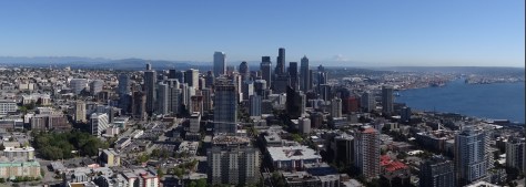
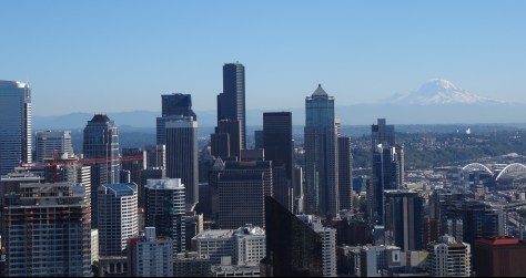
Space Needle and Chihuly
At the base of Queen Anne hill lays Seattle Center, the city’s art hub and site of the 1962 World’s Fair.
Museum of Pop Culture, Designed by Frank Gehry
Our tourist-ing time limited, we stuck to the top of our priority list, plus the crystal blue sky beckoned…
So it was up, up, up Seattle’s iconic landmark, the Space Needle. Across every direction, the vistas were amazing!
And how wonderful to see the glorious immensity of Mt. Rainier once again.
Directly adjacent to the Space Needle is Dale Chihuly’s Garden and Glass museum. We’d encountered a Chihuly sculpture outside the Montreal Museum of Art, and prior to that, in Texas on a medical school campus.
A similar installation sits in front of the Montreal Museum of Art
That first awe-inspiring experience hooked us and we were intrigued to learn more about the the Washington native, his vision, inspiration, and art.
Connecting rooms guide visitors across Chihuly’s career and creative explorations.
Chihuly was inspired by the Navajo’s use of horse hair and textiles in their pottery. We came across such pottery traveling through Navajo country and purchased a small vase as a memento.
Dazzling colors contrasted by perfect lighting and blackened walls bring whimsical glass structures dancing to life.
Outside, the colors and shapes meld with nature in larger than life blooms. A welcomed exaggeration to stimulate the senses and call appreciation to what may otherwise go unnoticed.
He is quoted as saying, “I want people to be overwhelmed with light and color in a way they have never experienced.”
To me, it is evident that Dale Chihuly is attempting to expand awareness, awaken and affect the soul.
His displays demonstrate vulnerability and fragility as necessary components of vibrancy and beauty.
A good lesson and exercise for the senses as we prepared for the next adventure… cruising Alaska’s Inside Passage.
Reconnecting with family and friends was just one of the many purposes of our trek around the U.S. So when the Martin side of my family scheduled a reunion, we parked the Escape Mobile in Seattle and hopped on a plane bound for Oklahoma.
Reviewing old photos
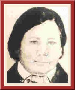
Martin isn’t originally my family’s name, but rather the result of the U.S. government’s forced assimilation practices on America’s native people. The name change came when my Cherokee great-great grandfather, Tsunigutlâhiduñ, or Tsu-ni-gu-hi-ga, attended the Choctaw Academy in Kentucky.
Hercules Terrapin Martin
I read that he chose “Martin” because it was a friend’s name, but my dad’s story was that he chose the name after the Martin bird.
Regardless, Tsu-ni-gu-hi-ga, which translates to Terrapin, became Hercules Terrapin Martin and thereafter his descendants were Martins.
Martin Cousins
When we have them, the Martin Reunions are scheduled to coincide with the Cherokee National Holiday, which falls over Labor Day weekend and celebrates the 1839 signing of the Cherokee Nation of Oklahoma’s Constitution.
The highlight of the weekend’s events is an intertribal powwow. We missed the powwow on this trip, but here’s some pics from a later visit:
Northeastern Oklahoma is the birthplace of my parents. My dad was raised near Tahlequah and mom in Tulsa. Loads of childhood memories took place in and around these communities.
Like the back of his hand, my dad knew the unmarked backroads surrounding Tahlequah, while Trey and I constantly relied on GPS to navigate between public landmarks…a painful reminder of regrets, squandered time, and unspoken words.
These columns are all that remain of the first Cherokee Female Seminary
Sequoyah statue on the grounds of Northeastern University
Tahlequah Roots
The trip’s first connections to family roots came outside of Atlanta when we visited New Echota and in Cherokee, North Carolina. However, the roots in Northeastern Oklahoma are closer to the surface.
And they’re roots we can engage.
Old Homeplace
Historical Marker – Hercules Martin’s Gravesite
Photos taken on a later trip
Major George Lowrey
Tulsa Roots
The Martin reunion was an opportunity to reconnect with my mom’s side of the family as well.
We loved touring Tulsa — visiting my mother’s old haunts…
Will Rogers High School, Mom’s Class – 1946
its awe-inspiring Art Deco architecture…
and recalling its significance in our country’s history.
While there was no gorgeous sunset to mesmerize us during this ferry crossing, we stayed entertained.
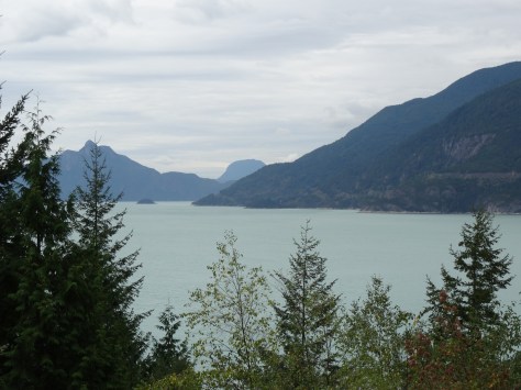
The drive took us into the center of Vancouver and across its harbor via the Lions Gate Bridge.
Sea-to-Sky Highway
The Beartooth Highway, which crosses mountainous passes between Montana and Wyoming, was distinguished as “the most beautiful drive in America,” and the Sea-to-Sky Highway from Vancouver to Whistler, British Columbia, was by far, our most beautiful drive in Canada.
The first half of the 120 kilometer drive hugs the coastline of Howe Sound and offers breathtaking views.
There are several lookout points to safely take in the beauty which stretched the hour and half drive into two and half hours.
Whistler, British Columbia
It was late afternoon by the time we arrived and checked into Lost Lake Lodge, located in a wooded area west of Whistler Village near Lost Lake Park. Although drained from the day’s travel, we explored the area by foot after eating dinner.
Lost Lake at Sunset
We discovered a series of foot and bicycle trails that we later learned were cross-country and biathlon tracks used in the 2010 Winter Olympics. The trails were fabulous for forest walks, and we were able to use them to bike into the heart of the village and all over the Whistler area.
We fell in love with Lost Lake that first evening in Whistler. Not only is it peaceful and beautiful, but it’s also off the tourists’ beaten path (hence its name).
We’d end each day with a walk or ride to its banks, stopping to watch for tiny Western Toads migrating out of area marshes.
Alta Lake is the area’s main water attraction with its beaches and canoe, kayak, and stand-up paddle board rentals. Challenging due to steep hills, we bicycled around the lake via the Valley Trail, a great way to experience both Whistler’s beauty and eccentricities.
Old Jalopies Along Valley Trail
Another great (but pricey) way to observe Whistler’s majestic surroundings is via the Whistler-Blackcomb Peak2Peak Gondola. Glass-bottom compartments cross the world’s longest and highest free-spanning wires joining Whistler and Blackcomb mountains.
Probably not an ideal ride for the faint of heart.
The $53 pass gave us all-day access to lifts, providing easy access to great hiking trails. We rode to the top of Whistler Peak for more phenomenal views.
Then hiked down to Harmony Lake and continued onto, and looped around, two lower lakes.
A steep, and somewhat strenuous trail, but we loved hiking among the fir trees, around glacial lakes, and along rocky ridges.
Arriving at Harmony Lake
Our time in Whistler helped to rejuvenate this road weary traveler. It’s lovely and relaxing. In fact, Whistler is one of only a couple of places we have revisited since concluding this six-month tour.
More pics…
The Black Tusk
Inukshuk
Mini Inukshuk on Whistler Peak with The Black Tusk in background
After a restful night in a Seattle hotel, and a fun breakfast at the Totem Diner in Everett, we entered British Columbia, Canada — a detour from our original plan to cross the Strait of Juan de Fuca via Port Angeles, Washington.
Our mistake was assuming our second ferry crossing experience would be as our first, where we drove to the landing, purchased a ticket at a drive-up booth, and then drove directly onto the ferry to cross Lake Champlain.
All crossings to Victoria from Port Angeles were sold out by the time we rose and attempted to purchase a ticket. In fact, our only option was to drive into Canada to the Tsawwassen Terminal, catch a 6pm ferry across the Strait of Georgia to Swartz Bay, and then drive 30 minutes to Victoria.
It was a long day, but the sunset views across the strait were well worth the trek.
Our cozy Airbnb apartment allowed us quiet time to sleep in and recuperate from the previous day’s travel.
It was afternoon before we ventured into downtown Victoria, where vibrant colors enhance the city’s energy – it was bustling, yet laid back and friendly.
The city’s center surrounds a busy harbor and is comprised of a mix of Victorian architecture, modern condominiums and shopping/tourist areas. It works, and we enjoyed walking around the harbor interacting with street artists, musicians, and other tourists.
Victoria is the provincial capital of British Columbia
Fisherman’s Wharf & Whale Watching
Float Houses in Fisherman’s Wharf
We arrived at Fisherman’s Wharf well before our scheduled tour in order to explore the area and try Barb’s famous fish and chips.
Barb’s lived up to the hype. We both agree they were the best fish and chips of our six month trip, a perfect mix of crunch and tender flaky cod. And not too greasy.
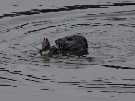
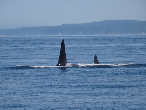
Eagle Wing Tours had favorable reviews and offered a wide range of whale viewing opportunities.
Although a beautiful, warm day, the speed of the boat amped up the effects of wind and sea spray requiring us to break out our rain gear.
The waters surrounding the San Juan Islands provide an ideal home to wildlife, and the perfect feeding environment for Orcas.
Subsequently, Victoria is home to many marine biologists who study and research the great mammals. Their decline in population, compounded by a lack of new births, is the greatest concern.
Orcas roam about in groups referred to as pods, and we encountered both the K and J pods during our outing. Overall, we witnessed six full breaches, and too numerous partial breaches and fin and tail slaps to count.
It was an incredible and magical day!
Our stay in Victoria passed quickly and did not allow time to explore all that Victoria has to offer, including Butchart Gardens. Gladly, we would have another opportunity to revisit the city three weeks later.
More pics…
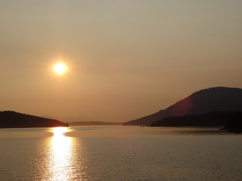
Sun setting over the San Juan IslandsView of Victoria from the harborAmazing tree on capitol groundsSeaplane coming in for a landingSailboat, Strait of Georgia at Sunset
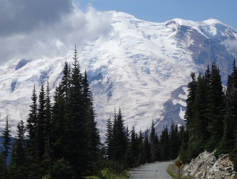
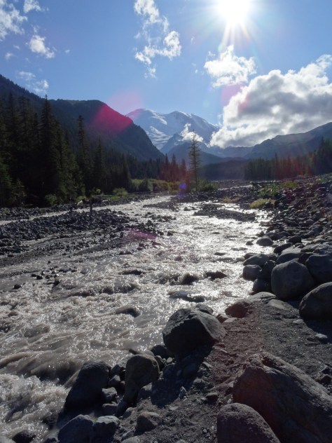
The immensity of Mt Rainier dominates the landscape from every approachable vantage point.
After connecting up with US-12 in Yakima, we entered the park’s east border via state highway 410.
The 14k+ mountain also dominates its national park. Within the park, it is not possible to traverse around the mountain by car. Getting from one area to another takes time and planning.
After much research, we chose White River Campground located more centrally within the park along the northeast facing slope.
White River Campground
White River offers convenient access to the hiking trails that attracted us. Plus, it sprawls along the bank of the White River, a raging storm of a river furiously fed by three glaciers.
We loved the non-stop sound of water forcing its way down Rainier’s slope, tossing boulders out of its way.
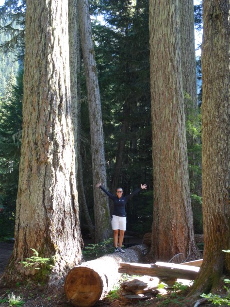
Excitement could not be contained at the sight of these giant Douglas firs!
Because White River campsites are issued on a first-come-first-serve basis, we had a “Plan B” reservation at a campground an hour and half away in the southern end of the park. We were able to cancel that reservation after securing site D17…
Loop D, Site 17 – White River Campground
located directly across from the Glacier Basin Trailhead and a short walk to the Wonderland Trail.
The nearest supply and grocery store is 25 miles away in the community of Greenwater.
Greenwater Outfitters — good coffee, breakfast and deli style sandwiches.
Glacier Basin Trail
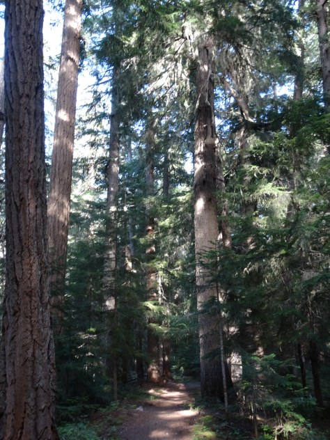
From our campsite, we followed Glacier Basin Trail into a thick grove of fir trees and past numerous creeks and waterfalls.
Glacier Basin Trail
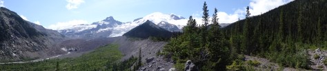
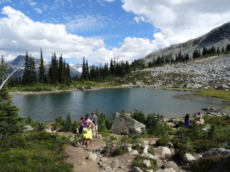
Just shy of a mile, we veered onto the Emmons Moraine Trail: a one-mile (roundtrip) excursion overlooking Emmons Glacier and a beautiful glacial lake.
Glacial Lake below Emmons Moraine Trail
Instead of trekking the additional 2.2 miles to Glacier Basin, we headed back to camp for lunch and a nap (I was fighting a cold).
Trey on the Emmons Moraine Trail
Re-energized, we hopped on our bikes and coasted downhill for six miles, past the Ranger Station to Highway 410. In hindsight, we both agreed the roundtrip hike to Glacier Basin would have been easier than the steep ride back up to our campsite.
Henry Weinhard’s Private Reserve – NW Style Lager
Sunrise Area & Wonderland Trail-North
Sitting more than 2,000 feet above the White River Campground, Sunrise has a restaurant, lodge and visitor center. It’s accessible by heading north (away from the river) on the Wonderland Trail for three miles, a strenuous hike due to the rise in elevation.
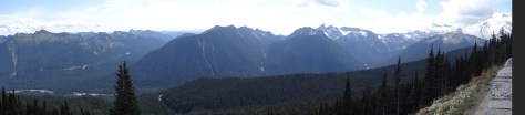
We opted to drive since we’d planned to hike some of the area’s many trails. Sunrise Park Road climbs up from the campground access road, through a series of sharp curves, switchbacks, and outlook points. Gorgeous drive! It provides many photographic opportunities of Mt. Rainier and its surrounding mountains, valleys, and glacial lakes.
Sunrise Lake, from Sunrise Park Road
Sunrise has ample hiking options for every level. From Sourdough Ridge we headed west to Frozen Lake…
Mart at Frozen Lake
looped south around Sunrise camp and Shadow Lake, then caught the Wonderland Trail back up to the Sunrise parking area.
The loop provided varied hiking environments, conditions and wildlife experiences.
Wonderland Trail-South
The Wonderland Trial encircles Mt. Rainier for 93 miles across varied terrains and elevations. It is a popular trail for fit and fervent thru-hikers.
Wonderland Trail Bridge Crossing the White River
With our tent and camping gear broken down and packed away in the “Escape Mobile,” we had yet to brave crossing the “bridge” over the White River to venture southward on the trail.
Trey went first.
Since we lacked the time and transportation to one-way hike to an access point along the campground road, we hiked only about 1/2 mile in before turning around and departing the campground.
Mt. Rainier stands out as a highlight among our camping adventures – it was our first experience among glaciers, and is a truly majestic towering beast of a mountain.
We will be back.
This is a record of Trey & Martha's 2014 U.S. travel adventures


")


")
")


")
")


")

")


")


 From our campsite, we followed Glacier Basin Trail into a thick grove of fir trees and past numerous creeks and waterfalls.


 It provides many photographic opportunities of Mt. Rainier and its surrounding mountains, valleys, and glacial lakes.


 Since we lacked the time and transportation to one-way hike to an access point along the campground road, we hiked only about 1/2 mile in before turning around and departing the campground.